
Perched on a bluff overlooking majestic Puget Sound is the unique acreage of Ebey’s Landing. In addition to the Bluff Trail, visitors can experience the seaport town of Coupeville, observe working farms, and get their fill of wildlife viewing, all in a tiny National Park on Whidbey Island.
There are two ways to access the Bluff Trail — either from the Prairie Overlook trailhead by the Sunnyside Cemetery, or from the seaside parking lot at the end of Ebey’s Landing Road. Hikers who want to enjoy a short beachside ramble would do well to begin at the parking lot off Ebey’s Landing Road, while those who want a bit more of a hike should start from the Prairie Overlook. Keep in mind that both routes do take hikers through private property, so be respectful of property lines.
The Prairie Overlook Trailhead has two parking lots. If you park in the lot across from the cemetery, take a moment to enjoy the view laid out in front of you. Mount Baker rests on the horizon to the east and other Cascade peaks march away to the south. To the west, the Olympics loom large over Puget Sound. Take the view in, then take a narrow, brushy, but thankfully short access trail along the driveway to the larger parking lot with trailhead kiosk and vault toilets. A sign here points west to the Prairie Ridge Trail which will pass by the historic Jacob Ebey house and blockhouse on your way to the bluff. Stay on the clearly marked route, walking past fields of wheat along the road. The way becomes more rugged as you head due west, changing from gravel to dirt, drawing you ever closer to the coast. If you want to add a little mileage, take the Pratt Loop trail from the east side of the parking lot. This trail takes you along the edge of the prairie to the old Pratt sheep barn and machine shed then into the woods where you may hear the rustle of quail or bunnies in the bushes. After 1 mile, join the Prairie Ridge trail that will take you to the bluff or loop back to the lot for a total of 1.3 miles.
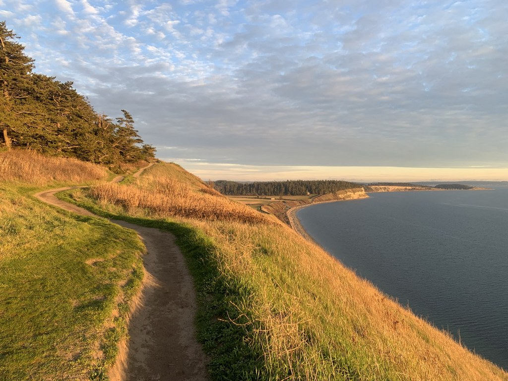
At the end of the Prairie Ridge Trail, you will come to a ‘T’ junction, where you can follow the trail either right or left. Take a right and head up a somewhat steep, but very short hill to a summit with a beautiful view of the beach below. From here, traverse along the bluff, enjoying the wildflowers on the slope to your left and the windswept trees to your right. The trail gradually descends along the bluff, offering an ever-changing perspective of the lagoon below, a birdwatchers haven. Hike until you come to a switchback, and descend steeply through several switchbacks to the beach. Ramble south along the beach until you arrive at the junction with the Ebey’s Landing parking lot.
Restrooms and informative brochures are available here, and note that if you start from this parking lot, a Discover Pass is required. Take a moment to learn about the history of the area before climbing two sets of stairs back up to the prairie.
Head north along the prairie to the junction you started at, and the turn right to return to the Prairie Overlook parking lot the same way you came. Be aware that there are stinging nettles on the brushy access trail on your return to the car — long pants and keeping an eye out will help prevent irritation from these little guys.
WTA Pro Tip: Be sure to stop at Kapaws Iskreme on Front Street in Coupeville on the way back from your hike. This quaint ice cream shop is generous in their portions, and it’s delightful to walk down to the wharf with your cone to see more beautiful views of Mount Baker.
Ebey's Landing

-
 Length
- 5.6 miles, roundtrip
-
 Elevation Gain
- 260 feet
-
 Highest Point
- 260 feet
Parking Pass/Entry Fee
Discover Pass
Perched on a bluff overlooking majestic Puget Sound is the unique acreage of Ebey’s Landing. In addition to the Bluff Trail, visitors can experience the seaport town of Coupeville, observe working farms, and get their fill of wildlife viewing, all in a tiny National Park on Whidbey Island.
Continue reading
Hiking Ebey's Landing
Map & Directions
 Trailhead
Before You Go
Parking Pass/Entry Fee
Discover PassWTA Pro Tip: Save a copy of our directions before you leave! App-based driving directions aren't always accurate and data connections may be unreliable as you drive to the trailhead.
Getting There
Prairie Overlook trailhead
From Mukilteo, take the ferry over to Clinton. Be aware that there is a toll associated with the ferry. Head north on SR-525 for 22 miles to a junction with SR-20. Continue straight on for approx. 5 miles to the town of Coupeville, and continue north on SR-20 for approx. 1 mile. Turn left onto Sherman Road and continue until you reach a right turn for Cemetery Road. Drive to the end of Cemetery Road to the Prairie Overlook trailhead, located directly across from a cemetery. If this parking lot is full, you can continue driving to the larger parking lot with trailhead kiosk and vault toilets.
Ebey's Landing trailhead
From Mukilteo, take the ferry over to Clinton. Be aware that there is a toll associated with the ferry. Head north on SR-525 for 22 miles to a junction with SR-20. Continue straight on for approx. 5 miles to the town of Coupeville, and continue north on SR-20 for approx. 0.3 mile. Turn left onto S Ebey Road and continue for approx. 1.7 miles until you reach a sharp right curve and a hairpin curve to the left. The trailhead is located at the right side of the hairpin curve to the left. Discover Pass is required to park here and overnight parking is prohibited. If the parking lot is full, you can park on the beach side of the road. Parking here between 10 pm and 5 am is prohibited.


