
A short but stiff climb through an old burn, old growth forest, and alpine meadows to a restored fire lookout standing sentinel over the western flanks of the Wild Sky Wilderness.
The first half mile climbs steeply on FS Rd. 6554 through old timber cuts and the Evergreen Mountain Burn of 1967. This was inadvertently set by loggers during a timber operation on the south side of the mountain.
Soon, wilderness is reached. Hikers will now enjoy a narrower, wilder trail and an easier grade than the logging road provided. Walk through young, regenerating forest to old growth mountain hemlock. At just under a mile, the trail leaves the forest for the splendor of alpine meadows and ever-increasing views of our Nation's newest wilderness (and beyond) as you follow the ridge crest toward your destination.
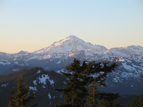
The trail swings around the north side of the mountain for one final push to the lookout, perched atop the 5,587 foot summit. Here, 360 degree views of peaks near and far soar above carpets of wildflower dotted meadows.
Stuart, Daniel, Hinman and other Snoqualmie friends lie to the south with Rainier watching over them all. To the west, view the gems of Wild Sky - Merchant, Gunn, and Spire – and to the north, gaze upon the Monte Cristo massif, Sloan, and Whitehorse. The meadows of Fortune and Grizzly backed by the Poet Peaks and Nason Ridge round our your view to the east.
Note – This is a dry trail, so bring plenty of water.
WTA Pro Tip: Make a full weekend of visiting the Wild Sky Wilderness by camping at the Beckler River Campground which is noted for its peaceful atmosphere. 27 sites including multi-family and wheelchair access.
River access is available while site privacy is provided courtesy of vine maples and shrubs. The campground is a good jump-off point for recreational activities in the North Fork Skykomish, Beckler River and West Fork Foss River areas. Campsite reservations may be made through www.recreation.gov.
Evergreen Mountain Lookout

-
 Length
- 2.8 miles, roundtrip
-
 Elevation Gain
- 1,425 feet
-
 Highest Point
- 5,587 feet
12.23.25: Beckler Road (FR 65) is closed until further notice due to flood damage.
Parking Pass/Entry Fee
Northwest Forest Pass
A short but stiff climb through an old burn, old growth forest, and alpine meadows to a restored fire lookout standing sentinel over the western flanks of the Wild Sky Wilderness.
Continue reading
Hiking Evergreen Mountain Lookout

WTA worked here in 2025, 2015, 2013, 2012 and 2011!
Map & Directions
 Trailhead
Before You Go
12.23.25: Beckler Road (FR 65) is closed until further notice due to flood damage.
Parking Pass/Entry Fee
Northwest Forest PassWTA Pro Tip: Save a copy of our directions before you leave! App-based driving directions aren't always accurate and data connections may be unreliable as you drive to the trailhead.
Getting There
From Everett, drive east on highway 2 for 50 miles, turning left onto the Beckler River Road. Proceed along this road for about 12.5 miles to a five-way intersection (the road becomes gravel at 7 miles). At the intersection, take the right hand fork signed Forest Road 6550, and proceed one mile to another intersection. Turn left, and drive to the trailhead, 9.5 miles along, at the end of the road.


