
The West Fork of the Foss River offers day-hikers and backpackers a range of options. Choose from Trout Lake (1.6 miles each way with 500 feet of elevation gain), Copper Lake (4.2 miles each way with 2400 feet of elevation gain), or Big Heart Lake at 7.3 miles each way, with 3300 feet elevation gain). Not enough choices? There's also Little Heart Lake between Copper and Big Heart Lakes, or Lake Malachite, a short side trip from the main trail before you reach Copper Lake.
So pick your goal, sign in at the trailhead and begin your hike. You will enter the Alpine Lakes Wilderness almost immediately. Along the trail, be alert for occasional exceptionally-large trees that somehow survived loggers and forest fires. When you come upon one of these solitary giants, reflect that trees of that size once were common in Northwest forests.
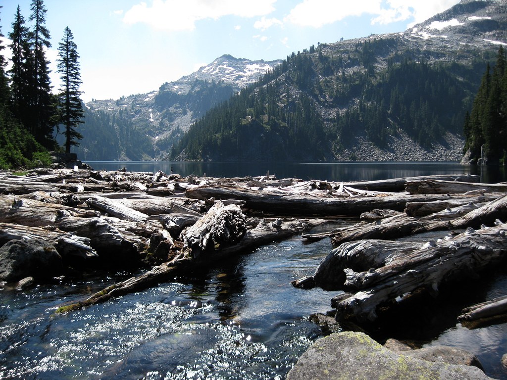
At first the trail is reasonably level, although that will change. In 0.9 miles come to a one-lane bridge across the West Fork of the Foss River, and pause to admire the stream. When you contemplate the steep grade, and the size of the tree trunks strewn along the rocky banks, you can understand how an earlier bridge was destroyed by flood waters and debris. The replacement bridge seems sturdy enough, and high enough, to survive for a while.
Continue on another 0.7 mile, with some uphill, and reach Trout Lake. Hikers or backpackers seeking an easier day may choose to stop here. The lake is in a pleasant forested setting, with several potential campsites, and there is a view looking up past the lake to some of the high country beyond. If you plan to continue on as far as Big Heart Lake, your route will take you up onto those heights, and you will have a view looking back down at Trout Lake.
The trail passes around the west side of Trout Lake, then begins to climb in earnest, gaining 1900 feet in less than two miles on a very rocky route. It has many switchbacks but not a lot of shade, so it's easy to get overheated here on a sunny afternoon. This is good incentive to start your hike early.
There aren't many wildflowers along this slope, but in summer you are likely to find pearly everlasting, a trace of yarrow, and some fireweed. As you climb, the sound of rushing water is always close by, and you will have occasional glimpses of the white rapids. Near the top of the switchbacks, an impressive cascade comes into full view. It's the outlet stream from Copper Lake plunging over the headwall.
Eventually you'll get above the cascade and come to a trail fork where a weathered sign indicates the way to Lake Malachite. Whatever your goal for today, don't rule out a side trip to Lake Malachite. It's just over 0.1 mile to the lake, with a somewhat stony climb of about 100 feet on rudimentary trail. Lake Malachite is a very pretty lake, particularly in morning light. You might even find a campsite along the eastern edge. Climbers intent on summiting 6,261-foot Malachite Peak sometimes bivouac here.
If you are going on, return 0.1 mile to the main trail and continue another 0.3 miles to reach Copper Lake, crossing the outlet stream on a picturesque group of secure boulders. Copper Lake is somewhat larger than Lake Malachite but in a similar setting, and there are good options for campsites along the northern shore.
Many day-hikers choose to turn around at Copper Lake, but the trail does go on. Follow a rocky trail along the eastern shore of Copper Lake, with some ups and downs, then head gently uphill toward Little Heart Lake. In summer, you might find blueberries or thimbleberries beside the trail, although they disappear quickly, thanks to wildlife and your fellow hikers. A few wildflowers bloom here, even a bit of beargrass, and there are some potential campsites along the way. Little Heart Lake itself is 1.3 miles from the outlet of Copper Lake, and it's about the size of Trout Lake. It has a very rocky shoreline, but you might be able to find some camping options near the outlet.
Beyond Little Heart Lake there is more elevation to be gained, about 700 feet in 1.1 miles, that will bring you to a high point. From there you can look back down on Trout Lake, and glimpse Glacier Peak looming dramatically in the distance. Also below, and off to the right, is Delta Lake.
Big Heart Lake is about 0.7 miles beyond the high point, and about 300 feet lower-elevation you will have to regain on your return. But press on, it's worth it. The trail descends gently, with an occasional switchback, then levels out and reaches a point overlooking the lake and its outlet stream. There is room for a few campers here, and there is a great view looking south up the lake.
It's possible to scramble across the log jam at the lake outlet and continue on rudimentary trails to reach Angeline Lake and other lakes. Check your map for possibilities. But you are 7.3 miles from the trailhead, and if you are a day-hiker then Big Heart Lake may be a good place to turn around. If you are a backpacker, you can set up camp at Big Heart Lake, and enjoy additional explorations the following day.
West Fork Foss River and Lakes

-
 Length
- 14.6 miles, roundtrip
-
 Elevation Gain
- 3,300 feet
-
 Highest Point
- 4,900 feet
Visit any of several beautiful alpine lakes, in rocky basins. The day can be as easy as a 3.6 roundtrip hike to Trout Lake, or as strenuous as the nearly 15-mile hike to Big Heart Lake as you like. Good options exist both for day-hikers and for backpackers.
Continue reading
Hiking West Fork Foss River and Lakes

WTA worked here in 2003, 2002, 2001, 2000 and 1999!
Map & Directions
 Trailhead
Before You Go
Parking Pass/Entry Fee
Northwest Forest PassWTA Pro Tip: Save a copy of our directions before you leave! App-based driving directions aren't always accurate and data connections may be unreliable as you drive to the trailhead.
Getting There
One half mile past the Skykomish Ranger Station on the Stevens Pass Highway (US-2), turn south on the Foss River Road (Road 68). The pavement ends in 1.1 miles, and beyond that be alert for occasional potholes.
Continue on Road 68 and in about 1.3 miles, pass under a railroad trestle. Just beyond the trestle, stay right at the road fork. In about another mile, stay right again at a fork. The left fork goes to the Tonga Ridge Trail. In another 0.6 miles, pass by the trailhead for the Necklace Valley Trail, and continue on Road 68. In 0.7 miles, be alert for a left turn onto Road 6835 signed for Trail 1064, your destination. This intersection has good signs but they sometimes are partly obscured by vegetation. Continue on Road 6835 for 1.9 miles to reach the trailhead, a total of 6.7 miles from US-2.
Note that some maps-including Google-incorrectly show Road 68 going all the way to the trailhead. It does not, so be alert for the left turn onto Road 6835. At the trailhead, there is a privy, but no regular water source. A Northwest Forest Pass, or equivalent, is required.


