
For those searching for alpine vistas and a solid workout, Greider Lakes is just right. This trailhead is located in the Sultan Basin Watershed, within the Morning Star Natural Resources Conservation Area, managed by the Washington State Department of Natural Resources. This is a special designation to protect ecologically significant areas.
You'll drive right up to the shores of Spada Lake and traverse two flat miles to reach the old trailhead. Once you reach the old trailhead, the climb begins. You'll be huffin' and puffin' as you conquer 40 switchbacks, gaining over 1,000 feet in 1.5 miles. The trail is rough, too — be sure to have good boots or hiking poles to help with the ascent (and descent, too).
But don't worry, the sweat you shed will be well worth it. The trail evens out after the fortieth switchback and you'll be minutes away from the shores of Little Greider Lake. Big Greider Lake is less than a quarter mile beyond that. Make sure to pack a hearty lunch; you'll be needing some replenishment.
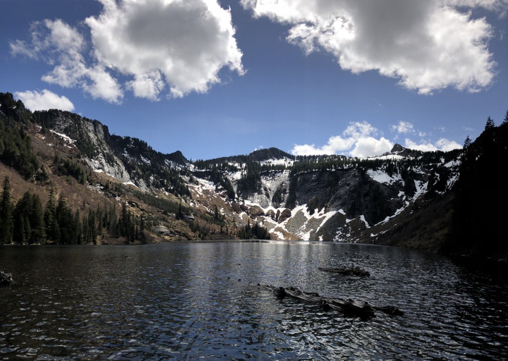
The edge of Big Greider Lake is an ideal lunch location, replete with a stunning view of exposed cliffs and jagged peaks across the lake.
WTA Pro Tip: Before starting your hike, be sure stop at the information kiosk, found 13 miles from the turnoff of Highway 2, in a turnout to your right. Hikers are asked to acknowledge that they understand the rules and regulations for visiting Sultan Basin, which is Everett's public water supply. These include no swimming in the lake, and appropriate disposal of waste.
Greider Lakes

-
 Length
- 8.6 miles, roundtrip
-
 Elevation Gain
- 2,035 feet
-
 Highest Point
- 2,930 feet
For those searching for alpine vistas with fewer visitors than on the most popular trails of the I-90 corridor, Greider Lakes is just right. This trailhead is located in the Sultan Basin Watershed.
Continue reading
Hiking Greider Lakes

WTA worked here in 2021!
Map & Directions
 Trailhead
Before You Go
South Shore Road and the trailhead may close to motorized use due to unstable slopes adjacent to the road during winter months. See https://www.snopud.com/community-environment/outdoor-fun/spada-lake/ for more details.
Parking Pass/Entry Fee
Discover PassWTA Pro Tip: Save a copy of our directions before you leave! App-based driving directions aren't always accurate and data connections may be unreliable as you drive to the trailhead.
Getting There
From Everett, take Highway 2 east to Sultan. Turn left at the traffic light east of town past milepost 23 onto Sultan Basin Road. Follow this road for just over 13 miles.
At 13 miles is a turnout to your right, with a kiosk. Stop here to sign in and get your free permit for parking. The paper you sign asks you to acknowledge that you understand the rules and regulations for visiting Sultan Basin, which is Everett's public water supply. Please read it carefully before signing and continuing on.
Straight ahead, the road forks. Take a right onto Forest Road 61, following signs to Greider Lakes. In 7.1 miles, you will reach the trailhead. Privy available.


