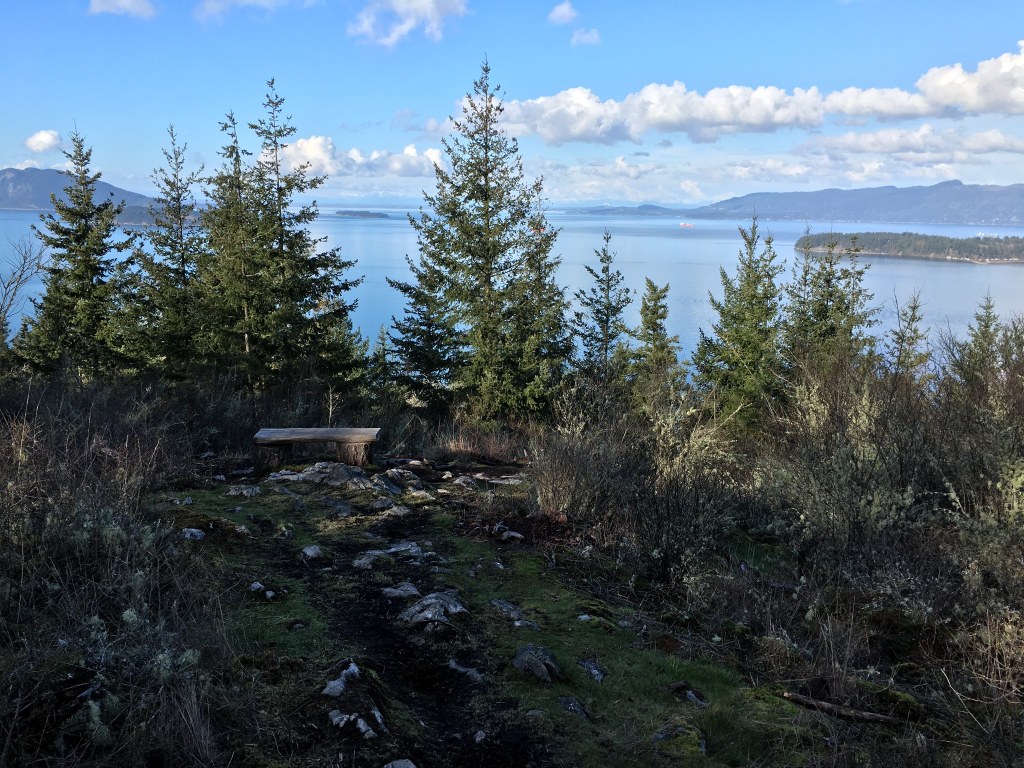
Guemes Mountain
WTA recently constructed this new trail to the top of Guemes Mountain on Guemes Island. The one-mile trail will lead to an incredible viewpoint overlooking nearby islands and ocean straits, the Skagit River delta, and the volcanoes and jagged spires of the North Cascades.
The Guemes Mountain Conservation Area was protected by an unprecedented partnership between Skagit Land Trust, San Juan Preservation Trust, and the residents of Guemes Island. Guemes Mountain is the highest point on Guemes Island and features stunning views of the San Juan Islands, Mount Baker, the North Cascades, and the Skagit flats. The mountain features a unique prairie habitat with a wide variety of flowering flora, small areas of wetlands and maturing forest. The 70-acre Guemes Mountain Conservation Area is at the center of a larger 534-acre area of protected private and public lands (see map). The protection of Guemes Mountain has ensured that this scenic location is maintained in a natural state for the public to enjoy. The hike climbs gradually through the woods to the top of Guemes Mountain. This short hike is a lovely treat year round. In late spring you are treated to wild roses and dozens of other little blooms along the rocky top. On a clear summer day you can see not only the surrounding islands but all the way to Canada's peaks. And in the fall you will be treated to autumn colors that speckle the lands below. Do note that this is a day hiking site only, and camping, fires, motorized vehicles, bikes and horses are not allowed.
Driving Directions:
From Seattle to Ferry Dock: Take I-5 north approximately 64 miles. Take exit 230 for WA-20 toward Burlington/Anacortes/Skagit Airport. Turn left (west) on WA-20 towards Anacortes. Follow WA-20 west for 11.7 miles. Continue straight on WA-20 West Spur for 2.7 miles and enter Anacortes (do not turn left towards Deception Pass/ Oak Harbor). Turn right on Commercial Ave. and travel 1.3 miles. Turn left on 12th St. and travel 0.5 miles. Turn right at I Ave. and travel 0.4 miles to the Guemes Island Ferry. Recent Trip Reports
Hiked here recently?
Submit a trip report!
There are
3
trip reports for this hike.
Day hike
Expand report text
Hide report text
Read full report
with photos
On this rather cloudy day, we biked to the Guemes Island ferry dock in Anacortes where we caught the...
On this rather cloudy day, we biked to the Guemes Island ferry dock in Anacortes where we caught the 9:45 am boat that shuttled us across the Guemes Channel. After the quick, 5-minute ferry ride, we walked our bikes up the ramp and turned right onto South Shore Road. As we biked along South Shore Road that paralleled the channel, we observed eagles soaring overhead and herons wading along the shore. After about a mile and a half, we followed South Shore Road as it turned to the left and soon arrived at the Guemes Mountain Trailhead. There’s a small graveled parking area and a bike rack which made it easy to secure our bikes at the trailhead.
This recently created trail is in great condition. It’s 2.5 miles round trip according to the sign and gains 600’ elevation. It begins in an evergreen forest which transitions into a deciduous forest and finally tops out in shrubbery, rocks, and grass at the top. The views at the top would be spectacular on a less cloudy day. We could just barely see the base of Mount Baker but could clearly see Anacortes and the surrounding San Juan Islands. When we returned to the trailhead, we continued our bike ride by going north on South Shore Road to Edens Road. Since it was not raining, we decided to check out Young’s Park on the north-eastern edge of Guemes Island instead of returning directly to the ferry dock. This park also has great views and a nice rocky beach. Soon after arriving at Young’s Park it started raining so we didn’t linger. We quickly ate our lunch and returned to the ferry via Guemes Island Road and caught the 1:15pm ferry back to Anacortes. Guemes Island looks flat when looking down on it from the top of Guemes Mountain, but while biking around the Island, we discovered it is actually rather hilly. Guemes Island makes a great day trip incorporating hiking and biking. The roads have no shoulders but that was not a problem since there was very little traffic. Our bike route covered about 10 miles. Day hike
Expand report text
Hide report text
Read full report
with photos
It was a beautiful day to be in Skagit County. From the ferry, we rode bicycles to the trail head an...
It was a beautiful day to be in Skagit County. From the ferry, we rode bicycles to the trail head and were pleasantly surprised to see a bike rack. The gentle trail winds around the mountain and at the top we enjoyed the 360 degree view. Mt. Baker was beautiful as well as the view towards Bellingham and the San Juan Islands. There were a couple families out enjoying the hike as well. A nice day trip. Stop at a local berry stand along the road in Anacortes or Burlington to get a taste of what's in season!
Guemes Mountain
— Jun 18, 2011
— 2cute2bLost
Day hike
Features:
Wildflowers blooming
Issues:
No water source
Expand report text
Hide report text
Read full report
Events of the morning put me on the 11:15am ferry; which was the last ferry before they broke for lu...
Events of the morning put me on the 11:15am ferry; which was the last ferry before they broke for lunch. I was only able to get on board as a walk on. I then hiked the 1.7 miles from the ferry to the trail head. Take an immediate right off the ferry. Its a 1/4 mile closer than the driving directions.
The trail head is well marked and there is parking for three trucks or four Prius. The barn across the street was used for WTA activities, but it is private and I would hesitate parking there, had I brought my Jeep. This being the first official day that the trail is open, the trail is in great shape! A nice gravel path starts things off, but quickly turns into dirt. There was a small bit of mud, but nothing uncommon after so much rain this year. The trail winds gradually uphill through this quickly maturing forest. Keep an eye open for some of the many critters which have taken refuge on this secluded island; including the occasional Sasquatch sighting. The last 500 feet of trail is very narrow and winds through some beautiful flora. This portion of the trail appears to be much older than the lower portion of the trail. I would guess this part of the trail was made by the locals over the years before this mountain became Trust Land. Also, being an original trail, this portion does have a few roots growing across it. So, stop looking for Bigfoot and watch your step for a few feet. When the trail turns into large areas of exposed rock, you're on the top. Now, lift your head and look west. Wow! Even on this cloudy June day, I could see most of the San Juan's and even a Canadian Mt top or two. Be sure to look down for the Ferries (the floating boat type) swimming in and out of the terminal near Washington Park; on the western point of Anacortes. The smaller ferry you took over to Guemes Island is also visible as it zips back and forth across Guemes Channel. I walked back to the ferry terminal, but had plenty of time to visit the store near the ferry and get some ice cream and a t-shirt before the ferry arrived. |
![]() WTA Volunteers head to the summit of Guemes Mountain for lunch. Photo by Michael Torok.
2010, 2011
Map it
|
Document Actions
- Email this page
- Print this
- Share


