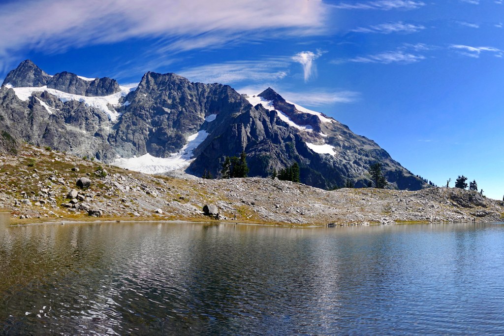
|
Copyright © Craig Romano/The Mountaineers Books Lake Ann (Mt. Baker Highway)
Mount Shuksan is the star on this glorious hike. Traverse forest and meadow, bogs and talus, all while anticipating the hidden gem of Lake Ann. And once she's revealed-dark blue-green waters often ringed in snow- her charm is enhanced hundredfold by the awesome backdrop of craggy, glacier-clad, 9127-foot Shuksan hovering above.
This trail is living proof that statistics lie. Consider: Start at an elevation of 4700 feet. Finish at an elevation of 4800 feet. Total elevation gain, 100 feet? Yeah, you wish! Lake Ann will cost you 1900 feet in gradient change, and quite a bit of that is on the return. So keep that in mind when toting along the little ones. Starting in attractive forest, begin a long descent into the Swift Creek valley. Tree cover soon thins, revealing Shuksan looking down on you. At 2.3 miles your downward drive bottoms out at a trail junction (elev. 3900 ft) set in a lush parkland of showy flowers and babbling creeks. The trail right heads down the Swift Creek valley toward Baker Lake. It's obscure and brushy, requires some difficult creek fords, and is definitely for the adventurous. For Lake Ann continue left, climbing 1000 feet through forest, then meadow, then rock, and then on slopes that often harbor stubborn snowfields. Reach a small saddle and rejoice that your climb is finished. Rejoice, too, when you look down into the rocky and snowy basin housing Lake Ann. Descend 100 feet to the sparkling jewel and savor its beauty. Gaze across its toe-numbing waters to a row of hemlocks dwarfed by Mount Shuksan behind them. Admire Shuksan's numerous hanging glaciers, which are deeply crevassed by late summer. Linger long enough to hear blocks of glacial ice crashing down valley floors and echoing through the wilderness. The Skagit people gave Shuksan its name, meaning "roaring mountain." A fitting name indeed.
Driving Directions:
From Bellingham follow the Mount Baker Highway (State Route 542) east for 34 miles to the Glacier Public Service Center. Drive another 23 miles (about 1.5 miles beyond the Mount Baker Ski Area lodge) to Austin Pass. The trailhead is on the left (elev. 4700 ft). Privy available. Note that the road from Picture Lake to the trailhead often remains snowbound well into August and sometimes all year round. Recent Trip Reports
Hiked here recently?
Submit a trip report!
There are
49
trip reports for this hike.
See all trip reports for this hike.
Day hike
Features:
Fall foliage | Ripe berries
Issues:
Blowdowns | Clogged drainage | Mud/Rockslide | Mudholes | Washouts | Water on trail | Snow on trail
Expand report text
Hide report text
Read full report
with photos
Arrived at the Lake Ann parking lot at 10:00 AM. There was already 5 cars there. The weather was coo...
Arrived at the Lake Ann parking lot at 10:00 AM. There was already 5 cars there. The weather was cool but not too bad. Weather report said the weekend was going to be nice and they were right. As I headed down the trail I could see the last of some great fall color that was fading fast. Once you get to the bottom you will be in a meadow of fall colors. The trail is very wet and muddy. The little mud puddles are frozen over and melting as the sun comes out causing a very muddy trail in areas. The trail is a little deceiving also since it starts off going downhill and levels off for a long time then it climbs pretty steady to the lake. It took me a little over 2 hours to get to the lake but well worth the hike. The views of Mount Baker, Mount Shuksan and Lake Ann were fantastic as can be seen by my pictures. I wasn't planning this hike this year but decided to go with the weekend coming up and good weather forecasted. I am glad I did. This hike was planned for next year when I have a goal of fifty hikes at age 50 but not too worry I have plenty of backups. I saw a number of people on the trail going in after 3:00 pm not prepared. Hopefully those who were not prepared to spend the night got out before dark. All and all this hike is well worth the effort with spectacular views. Check out my video of Lake Ann and Mt Shuksan on my You Tube Channel lmm3181 or here is the link
http://www.youtube.com/watch?v=234iePdDJyw Day hike
Features:
Wildflowers blooming
Expand report text
Hide report text
Read full report
with photos
Perfect morning in the north Cascades. Temperature was in the 50's and visibility was nearly unlimi...
Perfect morning in the north Cascades. Temperature was in the 50's and visibility was nearly unlimited. The plus of getting an early jump on the trail is having it all to yourself at dawn. The downside is walking through a thousand spider webs in the first two miles. Not that this ruined the experience, but it made for a bit of a distraction. The bugs were also fairly thick at the trail head but thinned out once I got under way. The trail itself is in great shape. There are only two small patches of snow left on the trail. The first is at about 3 miles and is only a few dozen yards across. The second is near the saddle just before you descend to Lake Ann. (The patches are small enough its not even worth toggling the “Snow on Trail” tag.) The wildflowers are still present but appear to have peaked. The lake itself is nearly devoid of snow.
Overall this is an amazing hike. The first two miles or so are mostly through forest and meadows. Once you start to put on elevation gain the views become stellar. You have to earn that last mile to the lake, but once you're there it's more than worth it. This trail doesn't have more than a few weeks before the snow sets in. If anyone is contemplating it now is the time. You won't be disappointed. By the way, big thanks to the Northwest Youth Corps folks that were doing some trail maintenance at about mile 3. Overnight
Features:
Wildflowers blooming
Expand report text
Hide report text
Read full report
with photos
The two guys that agreed to climb this mountain with me had never met each other, and I barely knew ...
The two guys that agreed to climb this mountain with me had never met each other, and I barely knew either of them. But they both had climbing experience and I was thankful of that. We hit the trail Saturday morning, I think around 9 AM. The first couple of miles through the woods was nice. The forest was more scenic than average and we past a couple of nice waterfalls. The hardest part of this climb came early. As we came out of the tree line and on to the snow fields, it started raining. We were dressed for a summer hike at this point. It started raining harder as the temp dropped 20 degrees and the rain turned to diagonal ice rain. This wasn't a crazy storm or anything, but quite uncomfortable. Our goal was to camp at 8000 feet, but had to settle for 7100' due to us being soaking wet and cold. Snow camping is tough when everything is wet. The weather did give us a break for the rest of the evening. I thought our chances of making the top were not good after experiencing how piss poor the weather can be up there. We made water, ate and slept. We got up at 2 AM. The sky was clear and we were ready to go. It took about six hours to make the top from there. With the moon reflecting the light off the snow, we didn't really need headlamps. It was windy at the top and there was smoke from wildfires all around. We headed back to camp, packed up, and did some suicidal glissading on our way down. I think our travel time was about 16 hours.
Overnight
Issues:
Snow on trail
Expand report text
Hide report text
Read full report
with photos
Six of us packed up and headed north to take advantage of unusually sunny winter weather. We snowsho...
Six of us packed up and headed north to take advantage of unusually sunny winter weather. We snowshoed up to Artist Point and set up camp. An attempt to ascend Table Mountain just came up short. Lots of other folks had the same idea. Many overnighters.
It dropped down to about 20 degrees at night. With a downmat, 10 degree sleeping bag, and a four season tent I was toasty. Very nice alpenglow at sunset and a nice sunrise too. On day two four of us headed back to Austin Pass then descended into the valley heading for Mt. Ann. The realative lack of snow made for more time consuming creek crossings that we expected. Not enought time to get to the summit so we changed plans. Instead we headed up to Lake Ann. Only saw two other people from Austin Pass on. Hot in the sun and a nice 1000' climb on the way out. All in all, a terrific weekend in February though it felt like May. I have a more detailed report with 65 photos on my site at: http://www.hikingnorthwest.com. Go to "Trips=2010" on the left margin. Day hike
Expand report text
Hide report text
Read full report
with photos
The road to Artist Point is closed for the season so there was an additional 1+ mile and 500' of gai...
The road to Artist Point is closed for the season so there was an additional 1+ mile and 500' of gain to the actual trailhead. Right now, any slope that is north facing above 4500' has some snow and or ice on it. That meant we had some snow to negotiate. Other than that, the trail was in great shape, the fall colors were at their peak, and there were still blueberries (albeit somewhat mushy). There was a moderate breeze at the lake and temps were barely above freezing. We found a protected area with knock out views of the Curtis Glacier. Our real goal for the day was returning via a cross country route on Shuksan Arm. Things were going great until.... We had climbed up another 500' or so feet to the ridge line and were proceeding along the ridge. Then... well, there was this steep mixed snow and rock gully to descend. Hmmm, no ice axes or crampons or even yak trax. It was a long ways back to re-trace our steps but there were several more knolls and gullies of unknown difficulty to negotiate. Soooo, back we went. Both of us were quite tired when we got back to the car at 5:45.
|
![]() Lake Ann trail. Photo by Stephen Alvarado.
|
Document Actions
- Email this page
- Print this
- Share


