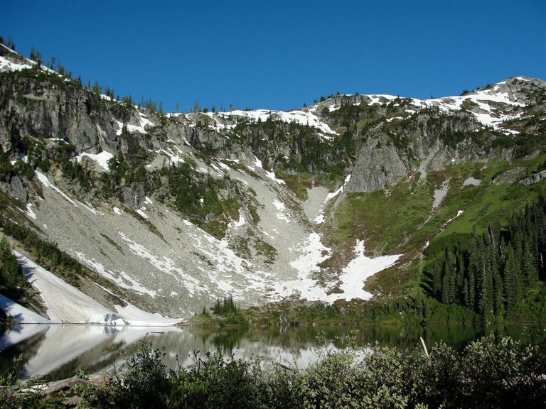
Lake Ann
Last modified
Oct 28, 2009 11:57 AM
Mount Shuksan is the star on this glorious hike. Traverse forest and meadow, bogs and talus, all while anticipating the hidden gem of Lake Ann. And once she's revealed-dark blue-green waters often ringed in snow- her charm is enhanced hundredfold by the awesome backdrop of craggy, glacier-clad, 9127-foot Shuksan hovering above. Recent Trip Reports
Hiked here recently?
Submit a trip report!
There are
20
trip reports for this hike.
See all trip reports for this hike.
Day hike
Features:
Fall foliage
Issues:
Snow on trail
Expand report text
Hide report text
Read full report
with photos
The promising weekend forecast led us up to Maple Pass Loop to check out the fall colors before further snowfall...
The promising weekend forecast led us up to Maple Pass Loop to check out the fall colors before further snowfall sets in. At the trailhead at 9:00 a.m. it was 31 degrees. The larches were certainly lovely and golden, but many still have a tad bit longer to go before their peak, but not much. We hiked counter-clockwise and took the side trail down to Lake Ann, which added an extra (easy) mile to the hike and was worth it for the lakeside scenery.
As was described in another recent report, there was off and on compact snow and ice on part of the trail as we descended. We had the instep crampons in the pack but since we had poles figured we'd be fine - well, at least that's what we thought until my companion ended up on the ground. Several people had the good sense to hike the loop clockwise, some to reduce the risk of a fall, and others to reduce wear and tear on their knees. Spectacular place. Greedily can't wait to return for the flower show next summer. Day hike
Expand report text
Hide report text
Read full report
with photos
If it is possible to have the perfect hike, this was it. The temperature was in the low to...
If it is possible to have the perfect hike, this was it. The temperature was in the low to mid seventies, with a light breeze, and not a single cloud in the sky...not even any haze. A cool, rainy spell the week before seemed to have sent the bugs packing. I probably saw a dozen mosquitoes all day.
This is a great outing for a party of mixed abilities: my husband took our 7YO and went to Lake Ann, and I took our 13YO and hiked up to the pass. We saw maybe 20 other parties. The Lake Ann trail is looking great. At the lake, there's lots of driftwood to play on, and the stream is wonderful for splashing. You'll also find plenty of shade for lunchtime. The loop trail is in beautiful shape; no blowdowns and very little overgrowth. As always, be cautious white hiking along the ridge on the west side of the lake. There are a few patches of trees on top where you can enjoy a lunch break. Even if you're heading back down from here (like we did, in the interest of time), make sure to plan for the hour or so to hike along the ridge with your camera. If possible, climb up to Frisco Pass; look for the wood pole indicating the high point of the trail at 6850 ft. A note about maps: My National Geographic TOPO software didn't have the loop trail. The TOPO kiosk at my local REI didn't show it either. Both of them did show the Lake Ann trail and the Rainy Lake trail. And the TOPO section was obviously the conjunction of four maps (which didn't match up well). The Green Trails maps show the trail, but to get the entire trail you will need to buy both #49 (Mt. Logan) and #50 (Washington Pass, I believe). I ended up printing the TOPO map for the Lake Ann portion, and greatly enlarging the lower-right-hand corner of #49 on my copy machine.
Lake Ann - Maple Pass Loop
— Aug 23, 2009
— runnergirl
Day hike
Features:
Wildflowers blooming
Expand report text
Hide report text
Read full report
I was blown away by this hike! Almost the entire course of the trail offers spectacular and ever-changing views of...
I was blown away by this hike! Almost the entire course of the trail offers spectacular and ever-changing views of jagged peaks, meadows full of wildflowers, and alpine lakes. The trail is rather steep at times, but you will be completely distracted from any strain by the beautiful scenary. The only downside to this hike is the noise from the highway (mainly at the beginning and end). Overall, I highly recommend this hike!!
Day hike
Features:
Wildflowers blooming
Issues:
Bugs
Expand report text
Hide report text
Read full report
with photos
This hike was great with amazing views. At the start of the hike near the Lake Ann turn-off there were...
This hike was great with amazing views. At the start of the hike near the Lake Ann turn-off there were a lot of bees around us but after passing the meadows no more bugs bothered us. The hike was not too hard except for a few sets of switchbacks climbing up to the ridge. The trail was sort of busy, we encountered about ten people but it was a Sunday. The loop takes you down by Rainy Lake after you reach the ridge at Maple Pass, which we had heard was steep, but seemed the same as the way up to me. Every part of the hike has new and beautiful views and I would recommend going now while the wildflowers are all still in bloom!
As a side note, we were camping at Lake Diablo and had used the Google earth feature on this website to get directions from there. It told us to go to Manzama Road when in fact the trailhead is located on Rainy Pass at the Rainy Pass Picinic Area, which was much closer to us. Overnight
Features:
Wildflowers blooming
Issues:
Bugs
Expand report text
Hide report text
Read full report
with photos
Please be aware that there is significant Black Bear activity in this area. On our overnight, we witnessed a very...
Please be aware that there is significant Black Bear activity in this area. On our overnight, we witnessed a very habituated bear walk directly up to a camp and destroy it - at 1:30 in the afternoon at Lewis Lake despite our attempts to spook the bear. We talked to the folks who's camp it was later and they said that their camp was 100% clean and we saw their food hung perfectly away from camp. This bear KNEW exactly what (s)he was looking for as it walked directly to the camp from a few hundred yards off. Spooky. We also heard many other reported sightings within in these drainages during our stay (Lake Anne, Heather Pass.) All this in addition to warnings posted of recent activity at Lake Ann. Travel safe or elsewhere!
Other than that, the flowers are still great! There also appears to have been some significant landslides into Lewis Lake in the winter/spring which has left the lake brown with silt. I heard there were large cutthroats in there but I'm wondering if there has been a fishkill as a result of the silt. It appears to be quite bad and no sign of any fish feeding. Bugs active but not intolerable. |
Driving Directions
From Bellingham follow the Mount Baker Highway (State Route 542) east for 34 miles to the Glacier Public Service Center. Drive another 23 miles (about 1.5 miles beyond the Mount Baker Ski Area lodge) to Austin Pass. The trailhead is on the left (elev. 4700 ft). Privy available. |
Document Actions
- Email this page
- Print this
- Share


