
Here's an unusual hike through a very mossy forest and along a narrow river canyon, past sites that were important in local history. A railroad once ran along the canyon, passing through small communities. Logging was done in the area, and lime once was produced from limestone here, in a kiln that still stands. The railroad and communities are gone now, and much has disappeared over the past eighty years. But a few artifacts still remain and can be seen near the trail.
The trailhead and much of the hike lie within the Robe Canyon Historic Park. Information about the park, and historical photos, are presented on a two-sided bulletin board at the trailhead. It's good material, although some of the text is printed in a relatively small font size, and glare from plastic covering the photos can make viewing them a challenge in some lighting conditions.
The route begins with a gentle climb of about 200 feet, followed by a gradual loss of about 600 feet before reaching a longer, nearly-level section along an old railroad grade. In fact, most of the elevation gain occurs on the return hike. The route crosses both public and private land, and the footing varies from old road beds to narrow, stony trail. There are numerous signs along the way, so route-finding is not a problem.
Begin your hike in a forested area, with an exuberant growth of ferns below. Then venture out onto a former road that traverses private property. In late summer, you may find a few ripe blackberries - not the native variety - beside the trail. The route leaves the road and heads downhill on a narrow, stony path passing close to Hubbard Pond. But the undergrowth near the trail is quite dense and you may have difficulty seeing the water.
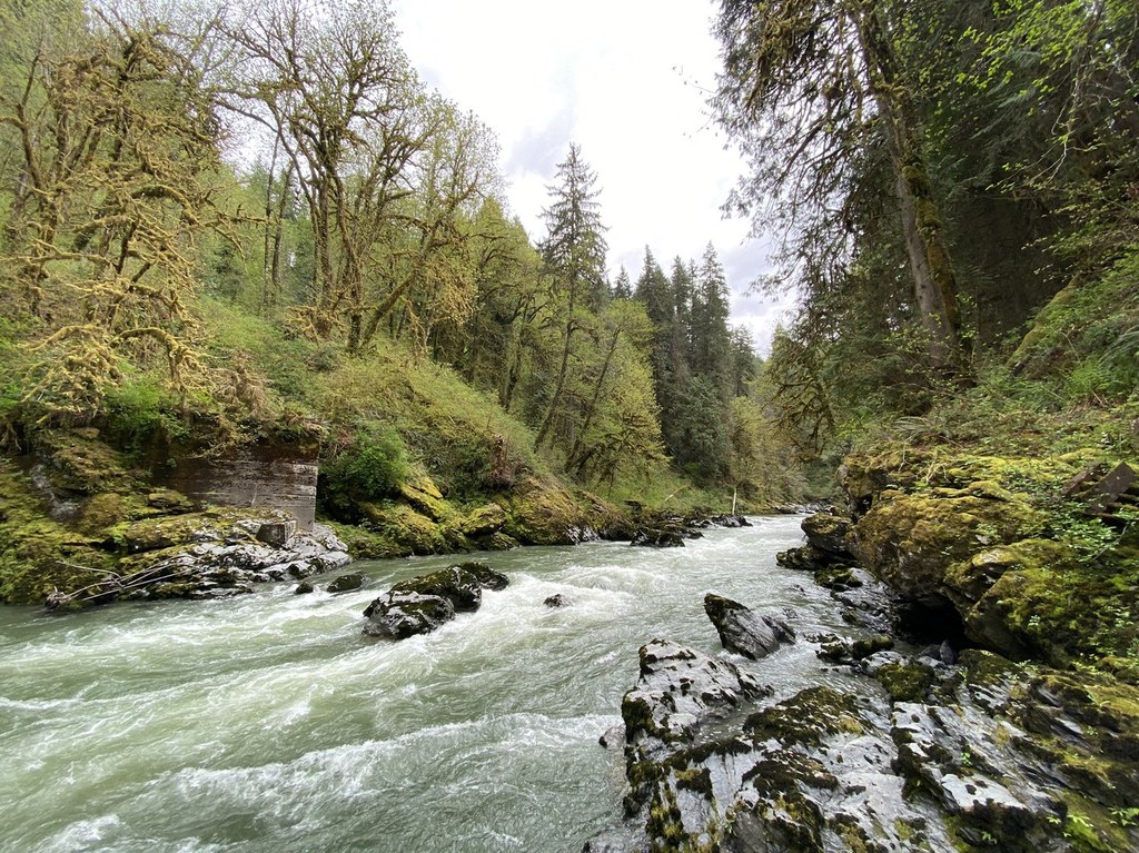
The route widens again, crosses a sturdy bridge and continues along another old road before turning left onto a narrow trail and heading downhill. You will hear the sounds of a creek off to the left, hidden beneath a lot of vegetation. The sound of flowing water increases as you approach the South Fork of the Stillaguamish, where the trail meets and continues along the former railroad grade.
Signs along the grade offer bits of history, including the route and dates of the Everett and Monte Cristo Railroad, the location of the former community of Cutoff Junction, and the site of a former logging spur railroad. Artifacts of various kinds appear near the trail. Some are easily identified, including remnants of a cast iron stove, broken pieces of rotary saw blades, old bricks, and a bent length of steel rail. Many of these items are quite photogenic. Feel free to take photos, but please leave the artifacts for future hikers to enjoy.
At one point the trail turns up a side canyon, climbs just a few feet, then crosses to the other side. Soon, the lime kiln looms up rather abruptly on the right, a short way off the trail. It's about 20 feet tall, with considerable moss and ferns adorning the sides. The overall form of the kiln and the shape of the arch on the side first seen from the trail, combined with the very green mossy surroundings, invite comparisons to a Mayan jungle ruin.
The kiln was built in the 1890s and used until the early 1930s to convert local limestone into "lime," i.e. calcium oxide. The product was transported by the adjoining railroad, mostly for use as a "flux" to promote melting of ores in smelters in the Everett area. The limestone apparently was loaded into the open top of the kiln from carts that approached from the uphill side. Unfortunately, none of the loading structure remains. The kiln has stoking ports on three sides where fires would have been tended--gathering sufficient dry wood as fuel in this very moist area must have presented a challenge!
Beyond the kiln, the trail follows the railroad grade upstream another 0.7 miles, where a sign directs hikers left for the 0.2 mile "River Shore Loop," or right for the "Railroad Bridge Site and End of Trail." Actually, you can go either way. Each branch of the trail loops back on the other, and part way around the loop there is a signed side trail that leads 150 feet to the site of the former bridge that once crossed the Stillaguamish, though nothing now remains of the bridge.
The loop trail does descend to the stony river bank for a close-up view of the water. In late summer or early fall the water level is low, the river flow is calm, and a bit of sandy beach may be exposed. But in winter or early spring the river can become a torrent and should be approached cautiously.
Lime Kiln Trail

-
 Length
- 7.0 miles, roundtrip
-
 Elevation Gain
- 625 feet
-
 Highest Point
- 750 feet
Parking Pass/Entry Fee
None
Here's an unusual hike through a very mossy forest and along a narrow river canyon, past sites that were important in local history. A railroad once ran along the canyon, passing through small communities. Logging was done in the area, and lime once was produced from limestone here, in a kiln that still stands. The railroad and communities are gone now, and much has disappeared over the past eighty years. But a few artifacts still remain and can be seen near the trail.
Continue reading
Hiking Lime Kiln Trail

WTA worked here in 2025, 2024, 2023 and 2022!
Map & Directions
 Trailhead
Before You Go
Parking Pass/Entry Fee
NoneWTA Pro Tip: Save a copy of our directions before you leave! App-based driving directions aren't always accurate and data connections may be unreliable as you drive to the trailhead.
Getting There
From SR-92 in Granite Falls, turn south on Granite Avenue. It's the main cross street in the old part of town and has a four-way stop. Go three short blocks and turn left on Pioneer Street, which soon becomes Menzel Lake Road. In about 0.8 mile, turn left onto Waite Mill Road. In just over a half-mile, drive past a wide school bus turn-around and note on the left the sign for "Lime Kiln Trail." Head left on the gravel road and, in about 500 feet, turn left into the signed Robe Canyon Historic Park and reach the trailhead parking area.
Parking is free, and no passes or fees are required. There is room for, perhaps, 25 cars at the trailhead. Note that the access road shoulder is signed "No Parking." A portable toilet may be available, perhaps seasonally. There is no water source.


