You are here: Home Find a Hike Hiking Guide Loowit Trail

Loowit Trail

The Loowit Trail circumambulates Mount St. Helens, dropping into and climbing out of deep gullies left by the eruption of St. Helens and its subsequent debris flows. This hike is very challenging, with sparse camps, little water and some sketchy sections of loose pumice. Since the eruption denuded the slopes of the mountain, you’re almost always in sun, so make sure you wear your hat and bring sunscreen. It is all too easy to get a severe sunburn on these slopes.

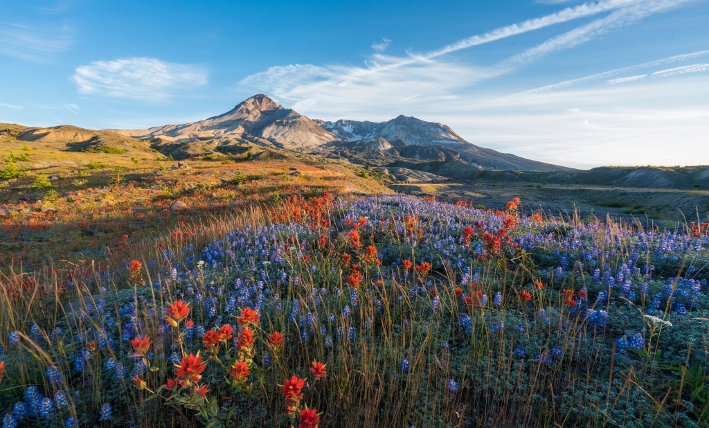
With those cautions in mind, you’ll fully appreciate the stark, otherworldly beauty of the blast zone. Vast fields of pumice gouged with deep gullies frame the gaping immensity of the mountain.

There are multiple points where you can access the Loowit, here are four of the most commonly used access points. (If you want a taste of the Loowit without the full meal deal, each of these hikes is a great way to sample the mountain.)

Windy Ridge
Follow the Truman Trail (#207) for approx. 3 miles, then take the Windy Trail (#216E) for another 1 mile to the Loowit (#216). This route will take you closest to “The Breach” and Loowit Falls. Note that camping is not allowed in the blast zone which includes the northern portion of the mountain between the South Fork of the Toutle River and Windy Pass.

Ape Canyon Trailhead
Park at the Ape Canyon Trailhead and go 5.5 miles on the Ape Canyon Trail (#234) to the junction with the Loowit (#216). Turn right (north) and hike another mile or two across the spectacular Plains of Abraham. Note this route is very popular with mountain bikers.

Climber’s Bivouac
Take the Ptarmigan Trail (#216A) 2 miles to the junction with the Loowit (#216). Turn left or right to experience the Loowit as it skirts the treeline along the volcano’s southern flank.

Blue Lake Trailhead
Follow the Toutle Trail (#238) for about 3 miles. Ascend the Sheep Canyon Trail (#240) 2.5 miles to the Loowit. You can make a nice lollipop loop by following the Loowit another 2.5 miles north to its intersection with the terminus of the Toutle Trail, then following the Toutle Trail approx 5 miles back to the Blue Lake Trailhead.

Circumnavigating Mount St. Helens
Some recommend starting from the south at Climber’s Bivouac while others chose to start on the NE side from Windy Ridge. In either case you need to plan on crossing the blast zone in one push as camping is prohibited between the South Fork of the Toutle River and Windy Pass. Since the most rugged section is on the west side where major washouts require extensive detours and/or scrambles, plan your trip to hit those sections when you are relatively fresh.

Although each year hikers do complete the Loowit, others have turned back unable to find safe passage through some of the gullies. Since conditions change so frequently and people’s route finding ability and tolerance for risk vary, it is impossible to predict if the circumnavigation is “doable” at any given time for any hiker.

This route description is for a counter-clockwise circumnavigation hike starting from the north side where the Windy Trail (#216E) meets the Loowit.

Your first seven miles will afford near constant views of denuded slopes as you cross the blast zone looking into “The Breach”. As you come around the mountain to the NW, the route drops into the valley carved by the South Fork of the Toutle. Here the trail is frequently obliterated by the river and sliding loose rock and pumice. Crossing this gully is the first of three major wash-outs on the route.

Continuing on the Loowit, the trail climbs up into remnant old growth forest on Crescent Ridge, and then enters a zone of burned trees and flower-rife meadows. You’ll enter subalpine forest, the trail climbing and falling until it again ascends to timberline near 4,700 ft. About a ½ mile beyond the junction with the Sheep Canyon Trail the Loowit was obliterated by a washout leaving a huge chasm with near vertical walls in its place. The Forest Service completed a bypass route that adds another few miles, but it is much safer than attempting to scramble through the massive gully.

Next, you’ll reach the junction with the Butte Camp Trail #238A. You can drop steeply along this trail—roughly 800 feet—to Butte Camp, if you need to make camp.

Most of the trail from here on in is rugged as it runs along lava beds to the junction with the June Lake Trail. For a pleasant campsite, follow the June Lake Trail (#216B) ¼ mile to its namesake lake. Continuing around the SE side of the Mountain you will encounter the 3rd major washout on the Loowit at Muddy Creek. It is approx. 4 miles from the June Lake Trail junction. Like the previous two washed out sections, the steep canyon walls and loose rock make it difficult and dangerous to scramble through the chasm. Currently there is no bypass route. However WTA volunteer Backcountry Response Teams are scheduled to restore this section in 2010.

You’ll traverse more lava on the 4.75 miles to the Ape Canyon Trail, and finally have 4 miles of relatively smooth trail across the Plains of Abraham, then up Windy Pass and back to the intersection of the Windy Trail (#216). From there you’re on familiar terrain following the Truman Trail (#207) back to Windy Pass.
Driving Directions:

Take FR 25 just outside of Randle, take FR 99 16 miles to its end at Windy Point. Walk the gated service road signed “Truman Trail No. 207” toward Mount St. Helens for two miles until you descend into a dry arroyo. From here, take the Windy trail #216E until you reach the Loowit at about 4,500 feet.

Improve or add to this guidebook entry

Recent Trip Reports

Hiked here recently? Submit a trip report!
There are 36 trip reports for this hike. See all trip reports for this hike.
Loowit Trail — Aug 11, 2012 — Weluv2hike.
Day hike
Features: Wildflowers blooming
Issues: Blowdowns | Overgrown | Mud/Rockslide | Washouts | Snow on trail | Bugs
Expand report text Hide report text
Jason and I got to windy pass and slept in the truck, woke at 4 am and was on the trail by 420am. At...
Jason and I got to windy pass and slept in the truck, woke at 4 am and was on the trail by 420am. At the juct with widy ridge we went clockwise with tr 216D then met up with the loowit trail. There was only one snow patch on the entire trail, mabey 10ft and was easy crossing. Passed several groups backpacking and only passed one group that was also doing it in one day. ( we saw them near june lake and the toutle river) Between butte camp and sheep canyon there is a re route..which adds mabey an extra mile to the trail. When you get to the boulder feilds, which there are several...keep the posts close by, as the trail is near by the posts. There are sections of the trail with flagging and carins..but only in certain stretches... flagging is far and few between, have a map. Route finding was not diffcult...but could see how it could be for some. At the toutle river, you will have to cross(get ft wet) mabey above the knee deep, not to bad. There is flagging where it is recommened to cross. Once out of the river there is a climb up a caynon wall, that is very, very steep. Then you make your way up to castle ridge, a section here.. mabey a mile or less feels very exposed,it is not but feel as though it is. One ft in front of the other, not looking down to with such a long drop to the bottom.Its kinda like the switchbacks climbing rainier, but without snow..sandy rock instead. Once at the top castel ridge...beautiful meadows, trees, flowers etc. Then into the breech area, which is alot of up and down washes, some with not even enough room for barley one ft. Studerbaker creek was swift, another ft wet crossing a total of two on the entire trail. This was a bit faster and deeper than toutle..Im 5 ft and it came upper thigh. No flagging here for recommend crossing.The trail all in all is diffcult, river ford, creek crossing, climbing rock, the washes etc. We had 2 meals, snack(sugar)...gummy bears, and starburst, and water..bladder pack filled. Also two filled water bottles to start.. fill on water when you cross it. We had water the entire trip, but filled a total of 4 times. We were back to the truck by 812pm.. 16hrs of going with an hour or so of breaks. The last 7 miles were VERY, VERY, LONG. A total of 35 miles hiked in a day, include re-route and windy ridge hike in and out from the loowit. I also added another trip report for this hike for additional photos of what to expect. We did it!!!
Read full report with photos
Loowit Trail — Aug 11, 2012 — Weluv2hike.
Day hike
Expand report text Hide report text
please see our other trip report for info about trail..just added this to put more photos in...for w...
please see our other trip report for info about trail..just added this to put more photos in...for what to expect on trail.
Read full report with photos
Ape Canyon, Loowit Trail — Jul 19, 2012 — Sunrise Creek
Day hike
Features: Wildflowers blooming
Expand report text Hide report text
Ape Canyon Trail is one of my annual hikes on Mount St. Helens. It traverses a diversity of landscap...
Ape Canyon Trail is one of my annual hikes on Mount St. Helens. It traverses a diversity of landscapes, climbing from the edge of the Muddy River lahar along a forested ridge to the pumice desert at the head of Ape Canyon and the Plains of Abraham.

Do not believe the sign at the trailhead. It says 5.5 miles to the Loowit Trail; the actual distance is around 4.25 miles. Since the Loowit Trail junction is beyond Ape Canyon, the distance to the canyon is closer to 4 miles.

If all you want to see is Ape Canyon, you can turn around there. I always go another mile or so to the Plains of Abraham. There is a terrific lunch spot and turnaround point at the cliff edge that offers grand views of Mount St. Helens and Mount Adams. The full distance is about 11 miles round trip and 1,900 feet of elevation gain.

Last year, we saw several mountain goats near our lunch spot; none were visible this year, but I did see goat hair caught in a willow beside the trail, so the goats are still around.

Every year offers something different to see. This year, it is the remains of a snow avalanche off of Mount St. Helens at the head of Ape Canyon. Normally this area looks like a dry, rocky river bed. This year, however, it is full of snow -- the first time I have ever seen it like that.

Ape Canyon got its name in 1924 when some miners, who had a cabin in the valley below at the foot of the canyon, reported to the Forest Service ranger at Spirit Lake that someone was throwing rocks off the cliff down on them. Unbeknownst to the miners, the ranger called all the boys at the YMCA camp on Spirit Lake "little apes." When he replied to the miners that it must have been the apes, they took him seriously. When the ranger realized he had the opportunity for a practical joke, he played it up. "Oh, I think some apes threw them down on you, all right. Haven't you heard of the apes up there? The apes roll those rocks down." The miners' story spread, and soon it was known at Ape Canyon.

The full story is recounted in "Spirit Lake People" by Alan Guggenheim.

Since the Ape Canyon Trail goes through different habitats, it offers lots of wildflower species. The trail starts in an old clearcut, now reforested. After about 1.5 miles, the trail goes into old growth forest. Admire the huge Douglas-firs, western red-cedars, and western hemlocks as you hike up a set of nicely graded switchbacks. The trail attains the ridgetop, passes some openings, crosses back and forth over the ridge, and descends through a saddle before the final climb and ridge cross-over.

The trail breaks out of the forest just a few hundred yards before it reaches Ape Canyon. The vegetation changes dramatically from forest to pumice desert.

Before the 1980 eruption, the Plains of Abraham were a green paradise of meadows, flowers and streams. The Plains are slowly being recolonized by pioneer plant species like lupines and penstemons. It is interesting to watch the changes from year to year, all beneath the east face of Mount St. Helens.

 
Read full report with photos
Plains of Abraham Loop, Ape Canyon, Loowit Trail — Jul 13, 2012 — Rebecca Lavigne
Day hike
Features: Wildflowers blooming
Expand report text Hide report text
What a spectacular section of St. Helens to explore! Based on Eli Boschetto's excellent recommendati...
What a spectacular section of St. Helens to explore! Based on Eli Boschetto's excellent recommendation (see his 7/7 trip report) I set out to hike Ape Canyon. Views of the mountain start pretty early, with Hood and Adams showing themselves too. Some woodland flowers were blooming in the understory (there are still some big trees here!)

The miles went by quickly and soon I was out of the trees at the junction of the Loowit Trail with the Plains of Abraham (how epic) in front of me. I was surprised to see a lot of bright pink heather in bloom among the rock here. This is where the Ape Canyon trail ends and I decided to continue on, turning right (east-ish) on the Loowit. Close-up views included blooming lupine and one very cute marmot. In the distance, Rainier shows itself.

In 1.8 miles I reached another junction, and turned left to continue on the Loowit to cross the plains to head up to Windy Pass. (This is the section that overlaps with the Plains of Abraham Loop.) As I left the plains and headed up a hillside loose with pumice and ash, there was a short section where the trail had eroded away. It required careful footing to make my way across this and regain something that looked like a path. Then, from Windy Pass, I had a new view: Spirit Lake.

This added about 5.5 miles to my total mileage for the day but was so worth it. Even if you don't have the time/energy to continue this far, as long as you are carrying enough water consider exploring a portion of the plains. All of the trail junctions were well signed.

It was a Friday and I only ran into 3 other groups the whole day - hikers, backpackers, and trail runners - no mountain bikers that day.
Read full report with photos
Loowit Trail, Windy Ridge Trail, Loowit Falls — Aug 26, 2011 — 2ByoungAGAIN
Day hike
Features: Wildflowers blooming
Issues: No water source
Expand report text Hide report text
Finally made it to Windy Ridge. Came up here in Mid-May only to find the same thing I encountered in...
Finally made it to Windy Ridge. Came up here in Mid-May only to find the same thing I encountered in Late June - Road Closed due to Snow to Windy Ridge. It's late August, temps around 90 and there is no SNOW except for in the shadows in the higher elevations. Arrived Thursday the 25th at stayed at Iron Creek campground which borders the Cispus River. Went up to Windy Ridge to watch the sunset that evening. It lived up to it's name, WINDY! Yes, it was certainly breezy to say the least. Hiked up the first portion of the trail that leads toward Loowit Falls for a look see of what Friday would bring me on the full hike. Ran into a small pile of Bear Scat, hmmm? Left after the sunseterrific colors were dissipating before it was totally dark. It's a mighty twisty road back to the route 25, especially till you get out of the blast zone.

Friday I arrived at roughly 10AM, No Wind? Loaded up my gear and set off down the ridge trail. About 1/2 way down I spotted a small herd (6 or so) of Elk grazing off toward the east on a lower hilltop. The sun was still partially hidden behind early morning cloud cover. Crossed paths with a solo hiker who had just about finished the Loowit Trail loop around the mountain perimeter; said it took him 2 1/2 days. Said it was hot! A couple on Mtn. Bikes road by soon after. By the time I reached the end of the trail at Pumice Flats it was getting pretty warm out. I decided to take of my lightweight long sleeve roll up sleeve hiking shirt and completed the rest of the hike in my synthetic activewear T-shirt. Had a hat, and ripstop cargo pants. Lots of beautiful wildflowers adorned the path on and off up to this point. I pass another solo hiker who looks really hot, not wearing a shirt and wiping sweat off his forehead with his T-shirt. As I reached the other side of the flats the heat begins to kick in a little more and I decide it's time for a small break, some water and photo ops of flowers and the terrain.

I continue on toward Loowit Falls as the blackbirds sit atop the marking posts in the distance. Usually not moving till I am about 15 feet away from them. As I enter large patches of wildflowers I can hear the buzz of the bees as they pollinate; paying absolutely no attention to me at all. The day is certainly heating up as I begin to feel the heat build up from the backpack I am carrying. Out of the nowhere I hear the sound of water as I come upon a muddy little runoff. I am hoping the falls are getting near. Some places the path is very soft and it is also very narrow. This is no place for carelessness and getting a twisted ankle. I hear the sound of water again as I come upon what appears to be an Oasis in the middle of the devastated blast path. And an Oasis it is! Willow Springs Oasis to be exact. You must walk through the runoff to follow the path that is shrouded in vegetation taller than most people. It's shady and cool in here! I will stop on the way back for a rest.

Loowit Falls shouldn't be too much further. The disappointing part of the journey; I didn't see a sign that ever said I was at Loowit Falls. It looks like the trail continued, on the opposite side of a very bouldery ravine.I began to go beyond what were likely the falls. The Lava rocks were getting very large and the ravine dropped down pretty sharply with no clear path to the other side, where I could clearly see a trail. I sat here a while debating what I should do. I then noticed this quite loud clicking type sound? What I wondered was that? It is so eerily quiet out here that all the noises seem amplified. It was the sound of flying grasshoppers! I sat here, took some close up shots of the west inside crater wall and ate a snack. After my break I decide to head back to the falls about 50 feet back or so; they must be the Loowit Falls,they just didn't seem very spectacular. I walked a little ways up towards the water and climbed alongside the rocky area next to the water. The soft footing was giving way some and I decided this might not be the right path or not to be climbed upon. There was a slightly larger fall drop, but still nothing worthy as I had thought. So I dropped back down to the run off level below the first falls I saw. While I rested here taking a break and snapping a few photos, another hiker appeared. He too climbed up the same area I did and soon after I began hiking back toward the Oasis, I heard him yell out "there are some bigger falls coming over a cliff higher up". He was apparently more determined than I to find something better and bigger and had.

I at that point was not thrilled by what I had seen and decided that I would just head back to the Oasis. Besides, I wasn't too sure if we were supposed to be climbing alongside the falls upwards to view them? Might not be considered the path and subject to the $100 minimum fine? Back at the Oasis I splashed some of the icy cool water over my arms and hands. Felt absolutely refreshing! It was absolutely beautiful here; as the pictures show. To me, this was worth the hike more than the falls I didn't see might have been. A true Oasis in the middle of a section of desert terrain. I could have spent hours here. Alas, that was not possible and after 30 minutes I decided it was time to head back to Windy Ridge. PS -Some have said the water here (Oasis) is fine to drink, I'd still not drink it without filtering unless you were absolutely dehydrated.

Various sites calculate the total journey I travelled at roughly 9.7 miles or so. I did it in 4 hours and 15 minutes, including all the photo ops and Oasis fun. I would definitely do this hike again and branch off to some of the other trails. There is Abraham Trail and of course Truman Trail just to name a couple. Mt St Helens is truly an interesting experience. I never thought I would be so drawn here, but I have been up here 3 times since Mid May and find it more interesting every time. Sadly, the campgrounds nearby all close at the end of September; I was hoping to return around Halloween for a Spooktacular weekend!
Read full report with photos
Wildflowers on the Plains of Abraham Scott.JPG
Wildflowers on the Plain of Abraham. Photo by Scott (tall guy).
WTA worked here!
2010, 2011, 2012
Location
Loowit (#216)
South Cascades -- Mt. St. Helens
Mount St. Helens National Volcanic Monument
Statistics
Roundtrip 28.0 miles
Elevation Gain 4100 ft
Highest Point 4800 ft
Features
Rivers
Waterfalls
Wildflowers/Meadows
Mountain views
Wildlife
Ridges/passes
Established campsites
User info
Dogs not allowed
Northwest Forest Pass required
Guidebooks & Maps
100 Hikes in the South Cascades and Olympics, Spring/Manning
Mount St. Helens NVM Trail Guide: http://www.fs.fed.us/gpnf/recreation/trails/documents/Mount_St_Helens_Trail_Guide.pdf
Green Trails Mount St. Helens #364 and #364S
Schematic Trail Map: http://www.fs.fed.us/gpnf/recreation/trails/locations/msh-0216-loowit.shtml

Improve or add to this guidebook entry

Map it
Red MarkerLoowit Trail
46.2496975 -122.1363446
  • BCRT 2010
  • BCRT 2012
  • Signature Trail 2010
(46.2497, -122.1363) Open in new window
Document Actions
  • Email this page
  • Print this
  • Share
Get the Guidebooks

Mountaineers three booksSelect content from The Mountaineers Books' guidebooks is featured in this Hiking Guide. Sales of the books from this website help protect and maintain trails.

> Shop Now

More hikes » Hike of the Week
Steamboat Rock (May 16)

Steamboat Rock

Eastern Washington

Looking for warm, dry hiking with stunning views and a post-hike swim? Climb to the top of Steamboat Rock and ramble the butte top for dramatic views of Banks Lake and coulee country. Desert wildflowers and camping options sweeten the deal.

Get Trail News

Subscribe to our free email newsletter for hiking news, events, gear reviews and more.