East Fork Foss - Necklace Valley
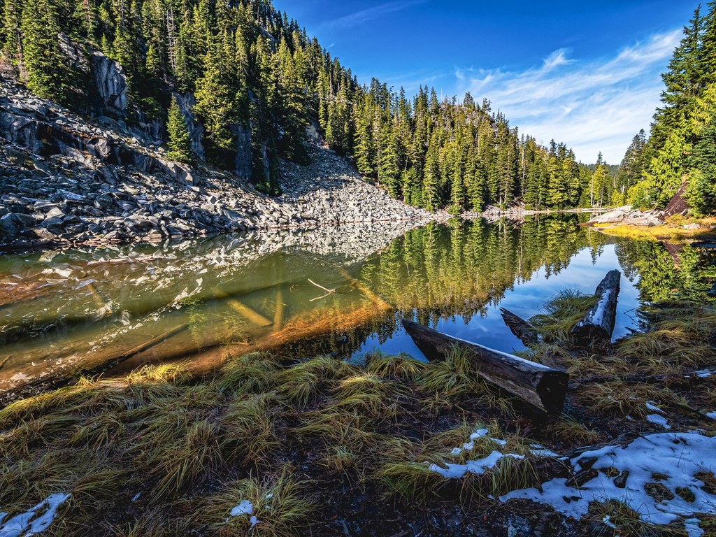
The East Fork Foss trail makes a lovely spring or early summer day hike or backpack. The challenging climb into the Necklace Valley well-rewards hearty hikers with cool alpine lakes named for precious gems that you can swim, fish in, or just camp beside.
The trail begins gently along the East Fork Foss River, traversing through a beautiful, naturally-regenerated forest that was logged by the railroads in the 1930s. The first five miles gain only 600 feet. Lowland forest wildflowers will keep your senses busy - look for trillium, calypso orchids, and yellow violets and more. This pleasant stroll abruptly ends when you come to the crossing of the East Fork Foss River. There is an established campsite here, and this is a good turn-around for a day hike of the East Fork Foss. Depending on the condition of the footlog and the amount of snowmelt in the river below, the crossing can be a little scary. Hold on to the handwire. After the crossing, the hike changes considerably as it becomes a steep, grueling climb, gaining 2400 feet in just 3 miles until you reach the first of the gems - Jade Lake. It's nice and peaceful, and there are established campsites here, but you will be amply rewarded if you push on to Emerald or Locket Lake. Be prepared for insects. Enjoy a few days exploring up here, scrambling over granite, breathing in the fragrant mountain heather, and relaxing in the shade of forest. No campfires are allowed, so be sure and pack your backcountry stove. From the cabin, a trail climbs, then drops west to Al Lake. There is a maze of social trails in this area. The upper end of this hanging valley accesses La Bohn Lakes and the standard route on Mt. Hinman. This is most pleasant as a snow ascent in early season, but the snow chute to the gap requires an ice axe. Once the snow is gone, Hinman is very rocky. In late season, follow the left edge of the talus as high as possible, then work left on a discernible scramble track that generally follows the right side of the La Bohn Lakes' outfall. Necklace Valley also accesses the Tank/Foehn Lakes areas. Ascend the very rocky, cairned medial moraine up this huge, recently glaciated cirque. Might be easiest in early season on snow. Please treat the fragile high country very carefully. For an adventurous hike one may continue from Tank Lakes in a generally south-westerly direction towards Iron Cap Mountain. Fred Beckey shows this route as the Alpine Lakes High Route (see Cascade Alpine Guide, #1, second edition, page 188). One may circumvent ICM to the north or go over it (both routes have their pros and cons and neither are simple). At ones discretion, descend to either Otter Lake or Big Heart Lake on fisherman's trails. From either one may gain the West Fork of the Foss River. This trail will join Road #68 just one mile south of where your car is parked at the east fork trailhead! Note that your mileage will increase to 22-26 miles with ~6500 in elevation gain.
Driving Directions:
To get there, from Everett drive east on U.S. Highway 2 toward Stevens Pass. After passing the Skykomish Ranger Station on the left, continue another 0.5 mile and turn right (south) onto Foss River Road (Forest Road 68).The clearly marked parking lot and trailhead will be on your left at 4.2 miles. Recent Trip Reports
Hiked here recently?
Submit a trip report!
There are
124
trip reports for this hike.
See all trip reports for this hike.
East Fork Foss - Necklace Valley
— May 11, 2013
— tristanhikes
Overnight
Issues:
Blowdowns | Snow on trail
Expand report text
Hide report text
Read full report
Hike up to the river crossing was relatively easy. Only a few fallen trees blocking the path here a...
Hike up to the river crossing was relatively easy. Only a few fallen trees blocking the path here and there. Nothing too difficult.
Ran into the snow fields that covered the trail about a mile up from the river crossing and attempted to find the trail for an hour or so. As our entire group was inexperienced route finder with no snowshoes/poles/crampons/axe this was a predictably stupid idea. Would make it 30 or so paces before falling through snow to upper thigh. Had to retreat back to river crossing to a great sandy campsite on the rivers edge. Great place for a short hike though! Overnight
Features:
Wildflowers blooming
Issues:
Blowdowns | Water on trail | Snow on trail
Expand report text
Hide report text
Read full report
with photos
Spent the night near Opal Lake. There are currently multiple open water sites in Necklace valley, s...
Spent the night near Opal Lake. There are currently multiple open water sites in Necklace valley, so no need to pack in water or fuel to melt it. There is one possible small campsite melted out at the entrance, near Jade Lake. I ended up camping on the snow-pack.
Snowshoes recommended, although on the way out I saw someone had followed my tracks in, wearing crampons. Tough dude, he sunk in 16" in many spots, and had post-holed up to his waist several times as well. There is a hazardous traverse above the creek, and I needed to cut steps down to the Nesby footbridge, so an ice axe is helpful. Continuous snowpack above about 3,000 feet, route finding skills were required. No bugs up there yet, although you'll encounter them in the Foss River Valley on the way in. Day hike
Issues:
Blowdowns | Mudholes | Water on trail | Snow on trail
Expand report text
Hide report text
Read full report
with photos
From the TH to the foot log over the East Fork Foss River (which is roughly the 5 mile mark) there a...
From the TH to the foot log over the East Fork Foss River (which is roughly the 5 mile mark) there are roughly 15 blow-downs. 1 or 2 of these will require climbing over, but none are a real issue.
The trail is fairly dry and in good shape. The only water on the trail or mud issues is where there are creeks coming across the trail or where there’s been snow melt. All creeks flowing over the trail can be stepped across fairly easily. Relevant patchy snow begins roughly 3.5 miles in, with the last .5 to .75 miles to the crossing being mostly solid snow. The snow depth is anywhere from 0 to 2.5’. There are sections where post-holing may be an issue. I would say that for most, navigation to the E F Foss crossing will be straight forward enough. When melted out and even now, the first 5 miles makes for a splendid early season hike. Cheers!
Mount Hinman, East Fork Foss - Necklace Valley
— Aug 11, 2012
— mOuNtAiNeEr51
Overnight
Issues:
Snow on trail | Bugs
Expand report text
Hide report text
Read full report
We camped past all of the lakes closer to the base of the pass up to La Bohn Lakes. Mosquitoes are a...
We camped past all of the lakes closer to the base of the pass up to La Bohn Lakes. Mosquitoes are a big problem in this valley, so be ready.
We left camp a bit after 6am. To get to the top of the pass, we went up a narrow gully in the center-left. There was snow in the gully, but we went up between the snow and the gully's right wall. Near the top of the gully, exit the gully to the right and scramble up rocks to the base of a short but steep pitch of snow. Ice ax is definitely needed here, and crampons are highly recommended. Go up the snow and follow it up to near La Bohn Lakes (but don't go down to the lakes). Near the lakes, we scrambled up the rocky nose leading up to Hinman's ridge. There are cairns that will guide you for most of the way up to the ridgeline. The rock is super nice to scramble on. Gain the ridge, and follow it up to a knoll, and go around it to the left on the snow. Walk up the snow, or get back on the rocky ridge spine, and continue towards the high summit ridge. When you get up to the higher summit ridge, stay left and traverse the very top of the snowfield to the far end of the ridge, where the true summit is located. Day hike
Features:
Wildflowers blooming
Issues:
Mudholes | Water on trail | Snow on trail | Bugs
Expand report text
Hide report text
Read full report
with photos
The trail starts off with minor gains and losses.... and stays that way... for quite a long time! Th...
The trail starts off with minor gains and losses.... and stays that way... for quite a long time! Then... Right as you think you can't take anymore... UP! and UP some more!
The calm before the storm (aka the valley hike) Overall the trail is in excellent condition- there are a few areas that you will touch minor vegetation but it is almost not worth mentioning (just be sure to avoid nettles if you go off trail) The climb up: The trail was excellent and had minor mud patches before Jade Lake. Nothing to be concerned about. I would HIGHLY recommend hitting the climb before the sun has a chance to warm it up. Otherwise you are in for a brutal climb. Drink lots of water. Necklace Valley hike: There is more mud here- the USFS is currently up there working their magic (anyone want to bring a few extra snickers bars for them? :) ) They are doing an amazing job- re-routing the trail and making lovely steps to help us enjoy the scenery up there. Tank Lakes Ascent: I will keep my language clean... Ooh my goodness. We hit the Tank Lake scramble during the mid afternoon heat. It is fully exposed and I got burned (I was wearing sunscreen...) We hiked up near the river and then climbed the spine- not necessarily the recommended route... the spine is a lot easier to follow... But it was just incredibly hot and it tired us out quite well. Snow begins at the top of the climb but does not require anything technical... just be sure that the snow you are standing on doesn't have a cavern/lake below. Follow the Cairns through the whole ascent- they help a lot. Tank Lakes was not crowded at all- there were 3 parties of 2 (Friday night), we passed quite a few people on the way down that had a destination of Tank Lakes... so it varies greatly depending on the day. The easiest way to keep the trail in your sights is to follow the spine up- it is definitely a difficult climb... but it has the most cairns to follow. There is a water source in the valley below the spine- so that helps if you run out of water/ want to cool down (it is a decent drop/cliff to get there for most of the way up though) Getting to Tank Lakes requires good route-finding skills, a good map/GPS with good maps loaded, and lots of water. Stay hydrated and be sure to stay protected from the sun. Remember to be safe! It is quite the climb and you are exposed to the elements for the entire way up. If anyone wants more information about the hike- I can provide more specifics via comment responses. Ooh... and the bugs are insane. :) |
![]() Beautiful Jade Lake in the Necklace Valley, Alpine Lakes Wilderness. Photo by Shahid Durrani.
2010, 2011, 2012
Map it
|
Document Actions
- Email this page
- Print this
- Share


