
A short, but rough hike to two small lakes on the eastern slope of Mount Pilchuck. The first, Bear Lake is under a half mile from the trailhead on a good trail. Once on the way to Pinnacle, however, the trail changes to a rocky, rooty, muddy mess, slow going up, and slow coming down. The reward for putting up with this mess of a trail, is a nice quiet little lake ringed by rocks and trees, usually not crowded, even on a sunny Saturday.
Start out on good trail, reaching a ‘Y’ intersection with a small sign on a tree. The right fork heads over to Bear Lake, a forested lake with good camp spots and a backcountry toilet. Admire the large cedar trees on your way to the lake. After checking out Bear Lake, go back to the intersection and head towards Pinnacle Lake.
You'll shortly arrive at a nice new bridge, built by WTA volunteers. Take a minute to look underneath at the sturdy sills (supports) and rockwork supporting the sills and decking.
After crossing the bridge, the trail deteriorates fast. Stomp through a large mudhole and get ready to switchback up, climbing ladders of roots and rock along the way. There are just enough sections of decent trail to reassure you that you're still on one. Keep a map handy so you don't get sidetracked by deceptive way trails that deadend in a jumble of brush. Once you reach the top of the ridge, you should be able to see Three Fingered Jack, Glacier Peak, and the tip of Mount Baker through the trees. Look over the ridge for a view of Bear Lake below you. The trail straightens out, passing through a couple of large mudholes, where early in the season there may be snow.
Soon you will reach a large tarn, sometimes mistaken for the lake by overeager hikers. It is pretty, but the actual lake is prettier, and larger. Follow the little stream that heads down from the tarn. The trail is still rough and you may find yourself picking your way through the huckleberries or hiking in the stream itself. What a good way to test those waterproof boots! But the lake lies ahead, with some nice lunch rocks waiting.
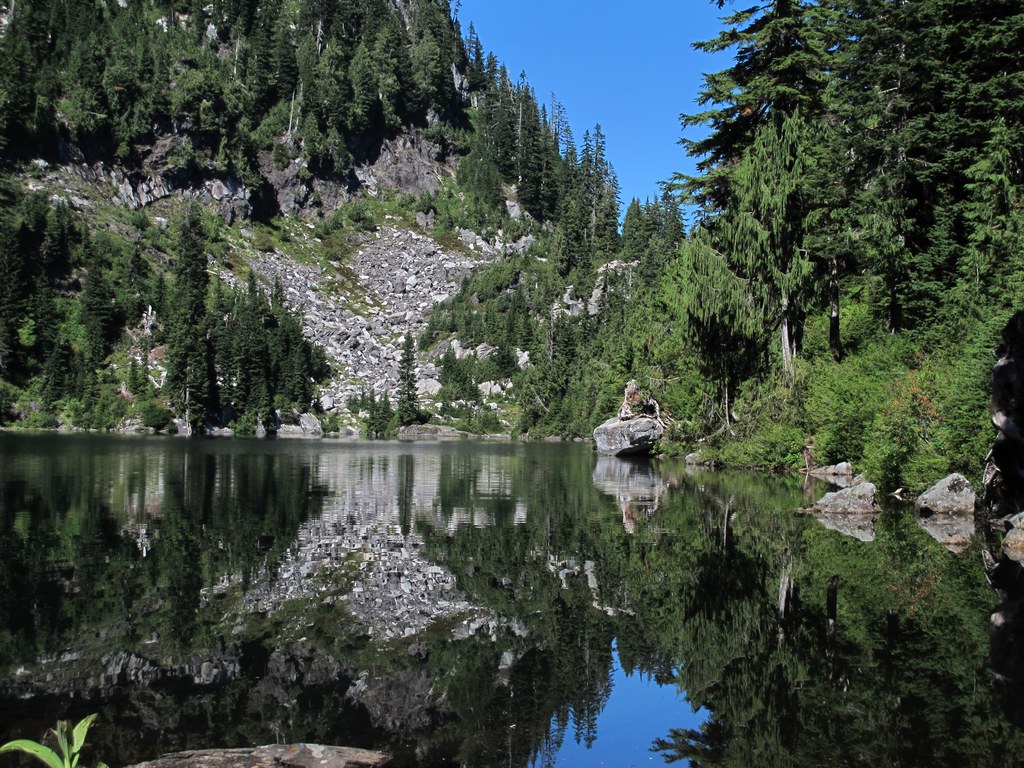
Once arriving at the lake, admire the spires of Mount Pilchuck, and notice how completely different the view from here is, compared to the one normally seen from the west side. There are plenty of places to sit and have a sandwich, but no level places to camp by the lake.
WTA Pro Tip: This area is a maze of old logging roads, and signs get shot up frequently and may be illegible. Have your Green Trails map handy to clear up any confusion.
Pinnacle Lake

-
 Length
- 3.8 miles, roundtrip
-
 Elevation Gain
- 1,200 feet
-
 Highest Point
- 3,800 feet
A short, but rough hike to two small lakes on the eastern slope of Mount Pilchuck. The first, Bear Lake is under a half mile from the trailhead on a good trail. Once on the way to Pinnacle, however, the trail changes to a rocky, rooty, muddy mess, slow going up, and slow coming down. The reward for putting up with this mess of a trail, is a nice quiet little lake ringed by rocks and trees, usually not crowded, even on a sunny Saturday.
Continue reading
Hiking Pinnacle Lake

WTA worked here in 2025, 2014, 2013, 2012 and 2002!
Map & Directions
 Trailhead
Before You Go
Parking Pass/Entry Fee
NoneWTA Pro Tip: Save a copy of our directions before you leave! App-based driving directions aren't always accurate and data connections may be unreliable as you drive to the trailhead.
Getting There
From I-5 in Everett, take exit 194 signed for Snohomish/Wenatchee, then take exit 204 for Lake Stevens. Follow this road for two miles, then turn left onto Hwy 9/9 N Granite Falls. Follow Hwy 9 for 1.5 miles and turn right on to E 92/Granite Falls. In 6 miles, come to a roundabout that has a log sign for Granite Falls.
Bypass Granite Falls by taking the roundabout, following Quarry Road. Stay on Quarry Road through two more roundabouts, and come to a stop sign. Turn left onto the Mountain Loop Hwy.
Alternately, one could stay on 92 and drive through Granite Falls, then turn left onto the Mountain Loop Highway.
Once on the Mountain Loop Highway, pass the Verlot Ranger Station on the left after ten miles of driving. 4.6 miles past the Ranger Station, turn right onto FR 4020, signed for Boardman Lake, Ashland Lakes, and Bear/Pinnacle Lake. Come to a junction in 2.7 miles and take the right fork, FS 4021. Stay on this road and in 1.4 miles there will be another junction. Keep right. Follow this rough road to the trailhead. The parking lot can hold about fifteen cars. There are no toilet facilities.


