
Lummi legend tells the story of the handsome young Kulshan, married to two wives: the beautiful but stormy Tahoma and the plain but kind Shuksan. Over the years, Shuksan’s gentle nature won the heart of Kulshan and drove Tahoma to jealous rage. She moved south, but finding herself separated from her family, she grew taller and taller in order to keep Kulshan within sight.
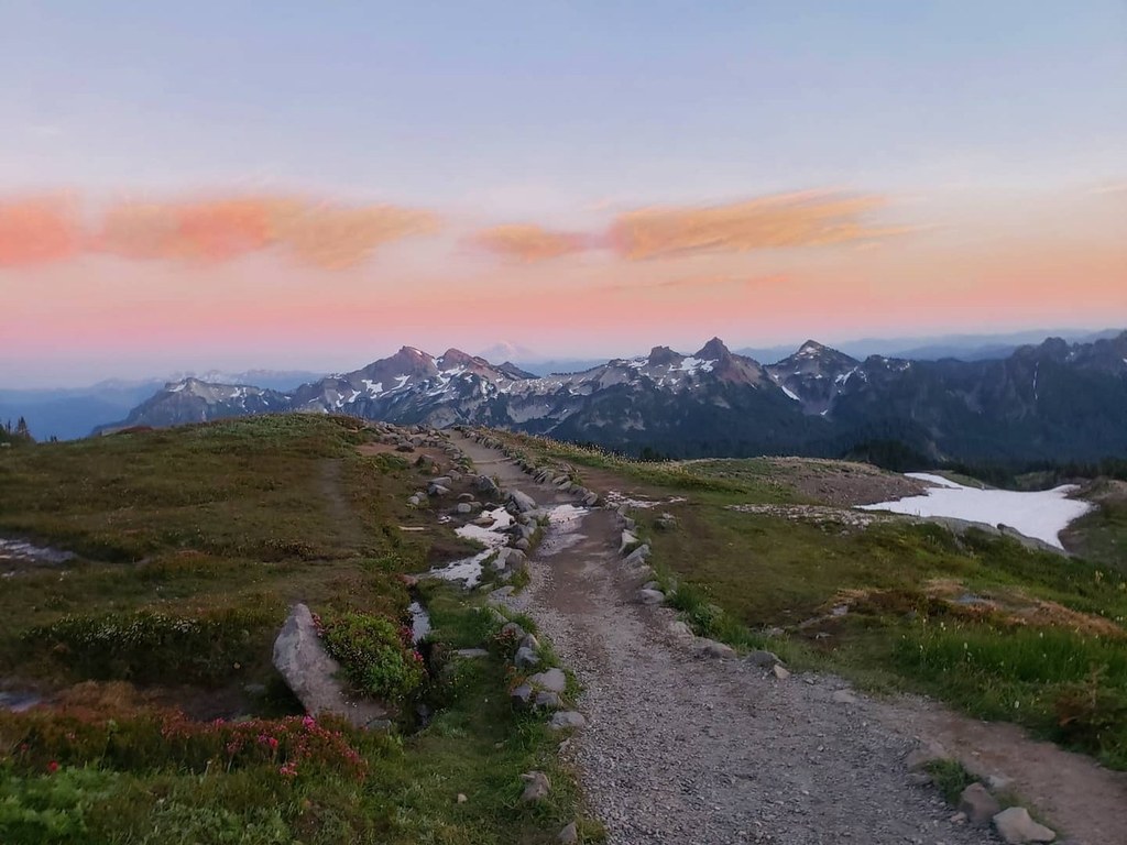
Kulshan, or Koma Kulshan, meaning “snow-capped mountain with a wound at the tip” in Lummi, or “hunting place in the mountains” in Nooksack, was named Mount Baker by George Vancouver in honor of his third-in-command in 1792. Thanks to Forest Service roads and the Skyline Divide trail, you can personally witness the beauty that drove Tahoma to jealous eruptions. The Skyline Divide is a 6000-foot-high northward extension of Koma Kulshan that transforms itself into a summertime paradise of unrivaled mountain views and unending wildflower fields.
The hike starts at a well-marked trailhead kiosk. Bring water with you, as there are no sources on the trail once snows have melted. Sunscreen is advisable, too, as the way is somewhat exposed. The trail gains 1500 feet in two miles to reach the ridgeline, so the grade is moderately steep as you ascend through a forest of western hemlock, mountain hemlock, and silver fir. Foamflower blooms in the summer, and huckleberries ripen late in the hiking season. Loving trailwork from WTA has led to steps and turnpikes that allow this trail to withstand up to 5000 pairs of boots each year. When you approach the timberline (elevation 5900 feet), fields of wildflowers bloom and views of Kulshan peek through the trees, but you ain't seen nothin’ yet!
Burst out onto a knoll on the ridgeline, with Kulshan confronting you to the south. Kulshan’s second wife, the non-volcanic Shuksan, is to the east, and the High Divide is to the north. The trail forks left, leading to potential campsites. Continue right and pass into the Mount Baker Wilderness. The hike continues 2.5 more miles on the gently rolling ridgeline over a series of five more knolls. At the second knoll, there is a fork. The path to the left takes you higher on a more difficult track, whereas the path to the right has more stable footing. At the third knoll, you face a similar left versus right decision. Regardless of your choice, the views are panoramic, and the flowers are ubiquitous. As you move southward, the views only get better as Kulshan looms larger and larger over the horizon. A partial list of the flowers that bloom on this part of the ridge includes aster, fireweed, arnica, oxeye daisy, lupine, valerian, bistort, glacier lily, and cow parsnip.
At the fourth knoll, 3.5 miles from the trailhead (6000 feet elevation), cairns mark a key fork. The trail to the left goes to campsites one mile away near Deadhorse Creek in the valley between the Skyline and Cougar Divides. If you turn right, you will ascend the spines of the fifth and sixth knolls. The farther you go, the more likely you are to meet chipmunks and grouse. The flower population changes as the terrain becomes more rocky and wind-exposed. Look for St. John’s wort, monkeyflower, harebells, heather, phlox, campion, paintbrush, silky phacelia, and penstemon. How many hiking guide entries need two flower lists?
As you summit the sixth knoll, you will reach 6,563 feet of elevation. Kulshan is just 3.5 miles from you. In front of you is Chowder Ridge, a trail best reserved for those with either hooves or the proper equipment for scrambling, snow, and ice. To the east are Yellow Aster Butte and Shuksan, and the North Cascades are in the distance. To your south are the Black Buttes (Lincoln and Colfax Peaks), the remnants of the local volcano that preceded Kulshan, and Twin Sisters Mountain. After you soak in the views, pull yourself away, if you can.
WTA Pro Tip: Many choose to camp and include the night sky among the incredible views found at Skyline Divide. Potential sites include the first knoll (left turn after achieving the ridgeline) or the Deadhorse Creek campground area mentioned above. An information-gathering stop at the Glacier Public Service Center is also a nice addition.
Skyline Divide

-
 Length
- 9.0 miles, roundtrip
-
 Elevation Gain
- 2,500 feet
-
 Highest Point
- 6,563 feet
The road to this trailhead (NF 37) is washed out 9.6 miles before the trailhead.
The Skyline Divide is a 6000-foot-high ridgeline extension of Mount Baker that transforms itself into a summertime paradise of unrivaled mountain views and unending wildflower fields, a trail that deposits you just 3.5 miles from the summit itself.
Continue reading
Hiking Skyline Divide

WTA worked here in 2021, 2020, 2019, 2018 and 2017!
Map & Directions
 Trailhead
Before You Go
The road to this trailhead (NF 37) is washed out 9.6 miles before the trailhead.
Parking Pass/Entry Fee
Northwest Forest PassWTA Pro Tip: Save a copy of our directions before you leave! App-based driving directions aren't always accurate and data connections may be unreliable as you drive to the trailhead.
Getting There
From Bellingham, take the Mount Baker Highway (SR-542) east 34 miles to the Glacier Public Service Center. Reset your odometer, and watch carefully for the junction with FR-39 (Glacier Creek Road), just 0.8 miles down the road and to the right. Immediately after the intersection with FR-39, follow the signs to the Skyline Divide Trail and turn left on FR-37. Continue for 12.9 miles until the trailhead.
FR-37 switchbacks up the mountain for 12.9 miles. There are potholes and several blind turns, so drive carefully! FR-37 ends at the trailhead, where there is a privy and parking for up to 30 cars and perhaps 20 more along the side of the road. The trail is open to hikers and llamas year-round and stock from August to the end of October. No campfires are permitted. Maximum party size is 12.