
This is a pleasant hike to a small lake and a notched gap with sweeping views. Sheep Lake is nestled in a subalpine area that explodes with wildflowers in July and August. The lake is a good place to relax and enjoy nature or perhaps take off your boots and go wading. Sourdough Gap is a small saddle in a rocky-edged ridge. The hike from the lake to the gap offers increasingly picturesque views of the south Cascades with every foot of altitude you gain. Once at the gap, you will be rewarded with grand views of Sheep Lake on one side and the Chrystal Lakes basin on the other side.
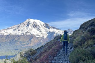
The hike to Sheep Lake is a 1.8 mile gentle climb on a good trail. The first mile traverses a steep slope above Highway 410. The hillside is decorated with wildflowers in the summer and red huckleberry plants in the fall. Although the trail dips in and out pockets of trees, the views are quite good, and you can get a bird’s eye view of the deep valley of the Rainier fork of the American River. You will also be treated to glimpses of Mount Rainier and Naches Peak.
After the traverse, the trail turns north, leaving the highway and the road sounds behind. The trail enters a forested area interspersed with small meadows, and eventually enters an alpine setting and climbs a bit more to Sheep Lake.
Sheep Lake is a green gem that pops into view as you near it. You may hear the happy sounds of children playing in the water or see hikers lazing on the rock outcropping where the trail comes to the lake. This outcropping is the perfect place to take a break, while the nearby beach may tempt you to take off your boots and go wading.
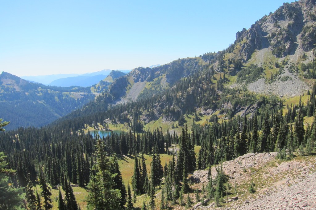
The hike in to Sheep Lake is good, but the 1.4 mile hike up to Sourdough Gap is even better. The trail wraps around the lake and then begins a steeper climb along the valley wall up to the gap. The scenery becomes more beautiful as you gain elevation. You can look down on the basin containing Sheep Lake. On a clear day you can see the surrounding South Cascades, including Mount Adams and Mount St. Helens.
Once at Sourdough Gap, the scenery is postcard beautiful with Sheep Lake and Mount Adams to the south and Placer Lake and Norse Peak to the north. You can also observe the Pacific Crest Trail as it continues north on the hillside above the Crystal Lakes basin.
After enjoying the views, retrace your steps to return to your car.
Sheep Lake to Sourdough Gap

-
 Length
- 6.0 miles, roundtrip
-
 Elevation Gain
- 1,100 feet
-
 Highest Point
- 6,400 feet
SR 410 (Chinook Pass) is closed between Crystal Mountain Boulevard (12 mi north of summit) and Morse Creek (5 mi east of summit) for the winter season.
Parking Pass/Entry Fee
Northwest Forest Pass
This is a pleasant hike to a small lake and a notched gap with sweeping views. Sheep Lake is nestled in a subalpine area that explodes with wildflowers in July and August. The lake is a good place to relax and enjoy nature or perhaps take off your boots and go wading. Sourdough Gap is a small saddle in a rocky-edged ridge. The hike from the lake to the gap offers increasingly picturesque views of the south Cascades with every foot of altitude you gain. Once at the gap, you will be rewarded with grand views of Sheep Lake on one side and the Crystal Lakes basin on the other side.
Continue reading
Hiking Sheep Lake to Sourdough Gap
Map & Directions
 Trailhead
Before You Go
SR 410 (Chinook Pass) is closed between Crystal Mountain Boulevard (12 mi north of summit) and Morse Creek (5 mi east of summit) for the winter season.
Parking Pass/Entry Fee
Northwest Forest PassWTA Pro Tip: Save a copy of our directions before you leave! App-based driving directions aren't always accurate and data connections may be unreliable as you drive to the trailhead.
Getting There
From Enumclaw, drive east on Highway 410 for about 50 miles to Chinook Pass. Continue about 0.2 miles to Pacific Crest Trail parking lot, which is the second large parking lot on the left side of the road. The trailhead is on the east end of the parking lot behind the vault toilets.
From Naches, drive west on Highway 12 to the junction with Highway 410. Turn onto Highway 410, and drive about 45 miles to the Pacific Crest Trail parking lot, on the right side of the road about 0.2 miles from the top of the pass. If you get to the Tipsoo Lake parking lot, you have gone too far. The trailhead is on the east end of the parking lot behind the vault toilets.
From Packwood, drive east on Highway 12 to the junction with State Highway 123. Go north on State Highway 123 about 16 miles to the junction with SR 410. Turn right onto SR 410. Continue about 0.2 miles to Pacific Crest Trail trailhead parking lot, which is the second large parking lot on the left side of the road. The trailhead is on the east end of the parking lot behind the vault toilets.