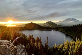
You are here: Home Find a Hike Hiking Guide Spray Park

Spray Park

» REI » Amazon

A portion of all book sales from the links above benefits WTA and helps protect and maintain our trails.

In many ways, you never recover from your first walk into Spray Park. The trail isn't difficult to follow. It's just difficult to forget. The 3.5-mile walk leads to seemingly endless open meadows of heather and alpine blossoms that tease the nose, ease the mind, and tickle the imagination. The place is a virtual lily factory. The so-called park itself--actually a vast corridor of open meadows interspersed among rocky moraines, lingering snow patches, whistling marmots, and sun-basking hikers--is a wonder to behold in the summer, truly qualifying as one of Rainier's most magnificent day-hike destinations.

Even though the Mowich entrance to Rainier is a lesser-used, backdoor way into the park, this trail also can be (understandably) quite crowded. But Spray Park is a broad enough area, rife with so many hidden pockets of meadow between rock formations, that it's still possible to grab some solitude among the blossoms.

From Mowich Lake, the trail drops quickly (less than 0.1 mile) to a junction with the Wonderland Trail and then climbs gradually for the next 1.7 miles through sun-filled forests. At this point, you'll find a broad side trail on the right leading a short 0.25 mile down to Spray Falls, a worthwhile side trip (seriously, do not skip this side trip).

After your 0.5-mile excursion to the falls, continue climbing as the trail turns steeply upward through a series of switchbacks. At about 2.5 miles from the trailhead, you'll climb out of the switchbacks and move across Grant Creek. The forest opens onto increasingly broad clearings and meadows, providing views of Hessong Rock (6385 feet) to the north and the hulk of Mount Rainier to the southeast.

The trail continues to climb, more gradually now, through broad fields of flowers. Stop anywhere along here--there are endless options for picnic spots with grand views. To find the best views, though, push on to the spine of the rocky ridge separating Spray Park from Seattle Park to the east. Here, at around 3.5 miles out, you'll find a cool rock garden at 6400 feet.
Driving Directions:

From Puyallup, drive 13 miles east on State Route 410 to Buckley. Turn right (south) onto SR 165 and proceed through Carbonado. Just beyond the Carbon River Gorge bridge, bear right onto Mowich Lake Road. Follow the road about 17 miles to its end; the trailhead is at the far end of the Mowich Lake Campground.

Improve or add to this guidebook entry

Note: the description and driving directions for this Mountaineers Books entry are copyrighted and can't be changed.

Recent Trip Reports

Hiked here recently? Submit a trip report!
There are 152 trip reports for this hike. See all trip reports for this hike.
Spray Park — Sep 30, 2012 — cjazzey
Day hike
Features: Wildflowers blooming | Fall foliage
Expand report text Hide report text
More difficult than I remember it being 12 years ago....
More difficult than I remember it being 12 years ago.
Read full report with photos
Knapsack Pass, Spray Park — Sep 27, 2012 — Maddy
Day hike
Expand report text Hide report text
The Knapsack Pass route turns the Spray park trail into an interesting loop. Beautiful scenery arou...
The Knapsack Pass route turns the Spray park trail into an interesting loop. Beautiful scenery around Knapsack and few people.

Start at the Mowich Campground and head north along the well marked trail that hugs the east shore of Mowich Lake. At .1mi and just past the Ranger's Cabin is a well worn path that leads to Knapsack pass. The sometime eroded trail gains 1300ft in 1mi. Descending on the east side of the pass is initially easy to follow then after crossing a small snow field it enters a boulder field with occasional cairns. Cross another snow field and enter a nice meadow with a few tarns. The trail crosses a 3rd snow field then slowly becomes a defined trail again as it crosses the east shoulder of Mt Pleasant and then drops down to the Spray Park trail. It intersects the spray park trail about 1/2 mi from it's high point. Check out Spray falls and Eagles Nest view on the way back. Today was sunny and warm but unfortunately the haze from fires made views of Rainier very washed out.
Read full report with photos
Spray Park — Sep 21, 2012 — Wendy W
Day hike
Features: Wildflowers blooming | Fall foliage
Expand report text Hide report text
We left Tacoma with our wipers on with hope the weather would be better at The Mountain. It wasn't u...
We left Tacoma with our wipers on with hope the weather would be better at The Mountain. It wasn't until we were past the Paul Peak trail head and almost to Mowich Lake that we rose above the marine layer and into the blue skies and sunshine.
The trail is in great shape and easy to follow. The flowers are past their prime but there are still some pretty ones. The falls colors are coming on strong.
We spotted a bear up on the hill below and right of Hessong rock. It was fun to watch it wandering all over the hillside looking for food.

We kept going through Spray Park past the "Top elev 6400" rock, across a snow field to two big cairns. Here the trail goes steeply downhill and to Seattle Park. We wanted to go down there but knew there wasn't time to go that far and get back to the car before dark. We so envied those that were spending the night. We'll be back!
Read full report with photos
Spray Park, Hessong Rock and Mount Pleasant — Sep 20, 2012 — Playapixie
Overnight
Features: Wildflowers blooming | Fall foliage | Ripe berries
Issues: Bugs | No water source
Expand report text Hide report text
Are you ever so delighted by an experience that you almost feel like you are getting away with somet...
Are you ever so delighted by an experience that you almost feel like you are getting away with something? That's what my September 20, 2012 overnight into Spray Park with my friend Jeff felt like: a few lingering wildflowers and blueberries, perfect sunny weather, soul-inspiring stargazing, jaw-dropping views from the flank of Rainier, early fall colors, solitude, and a peaceful bear, and all just two days before the official start of fall.

We weren't sure if we'd be able to camp in Spray Park (only two parties are issued cross-country permits for that area, and it took some sweet-talking of the ranger to even be issued one of them), but we got lucky, and I believe we had the entire area to ourselves on Thursday night. We got a late start up the trail at 2:30PM, and only encountered a few day-hikers and one fellow headed to Eagle's Roost camp. By sunset, Spray Park was all ours, and we didn't see or hear another person until around 10:30 the next morning. Stargazing from the meadows was epic, as there were clear skies and no moon (although wildfires in the Cascades and the lengthy high pressure system we've been having in the region made for a bit of haze.)

The next morning, a bear joined us for our yoga/meditation hour, and hung out at a respectful distance. I first spotted him between my legs from Downward Dog pose (!) maybe 300 yards up the hillside towards the ridge between Hessong Rock and Mt. Pleasant. He eventually meandered to within 40 yards of our camp, but never acted threatening, although he clearly knew we were there. We watched him for at least an hour before he eventually wondered out of site to our west (after first checking out our camp kitchen, where we had wisely cooked our delicious Salmon dinner the night prior quite a safe distance from camp, though nothing of ours remained there at that point.) I was glad we had carried in a bear canister (borrowed for free from the ranger station at Carbon River), as there are no good trees for hanging food at that altitude, and salmon and veggie-scented trash in a tree would probably have been all too inviting.

Friday afternoon we hiked straight up the little trail from Spray Park to the ridge between Hessong Rock and Mt. Pleasant, and followed the trail along the ridge to the top of Mt. Pleasant. Fantastic views of Fay Peak, Knapsack Pass, Mist Park, and Seattle Park awaited (stirring up schemes for a multi-night trip in the region during wildflower season.) To the west, low overcast at around 4500 feet obscured Mowich Lake and everything westward (reinforcing our giddy feeling of getting away with something, since we were in 70 degree sunshine, knowing that everyone at home was having a gray Seattle day.) From Mt. Pleasant, we followed the ridge between Seattle Park and Spray Park, where we serendipitously ran into our friend Sheri (who had hiked up through Knapsack Pass earlier that day.) We then followed the ridge trail further to where it joined the main Spray Park trail, and back down to pack up our camp and head back for the trailhead.

One last break for a small dinner at the viewpoint just below Eagle's Roost gave us one last sweet surprise. Right around Eagle's Roost we began descending through fog, and when we first arrived at the viewpoint, Mt. Rainier was completely obscured in clouds. But within just a couple of minutes, it completely cleared, and we drank in a pink and gray dusky mountain landscape with our last trail meal, the icing on the cake of an entirely perfect weekend.

By the time we reached the parking lot, at around 8PM, it was dark, and we needed headlamps for the last 3/4 mile or so. We passed several groups (including one very large group headed for Eagle's Roost) who were on their way in, and the campground at the trailhead and the parking lot were both packed with friday night visitors, presumably staging for an early start for their saturday morning hikes. We were even more grateful that we'd hiked thursday/friday, as we realized just how popular Spray Park is, and just how lucky we were to have it all to ourselves.

Note: After the creek right before the entrance to Spray Park, we found no running water. The only water sources we found were a few stagnant ponds (most of the creek beds and ponds were dry.) We were very glad to have a good water filter rather than just tablets or boiling for purification. We would have filled up with drinking water at the creek if we'd realized this. Also, the mosquitoes were pesky around dusk, but otherwise not much of an issue at all.
Read full report with photos
Knapsack Pass, Spray Park — Sep 16, 2012 — sorg
Day hike
Features: Wildflowers blooming | Fall foliage | Ripe berries
Issues: Snow on trail
Expand report text Hide report text
My friends and I found the trail head to Knapsack Pass just past the Ranger cabin on Mowich Lake. We...
My friends and I found the trail head to Knapsack Pass just past the Ranger cabin on Mowich Lake. We hike up through forest which occasionally broke into open spaces of ponds and wildflowers. Everywhere along this stretch was within earshot of babbling streams and miniature waterfalls covered in moss. We eventually broke out into rocks and sun and the climbing seriously began up towards Knapsack Pass along piles of boulders, bonsai trees and green cliff beginning to stain autumn red.

Views from the top of the Pass were amazing with Mt Rainier peaking out on the right. We descended along a rocky path towards a small snowfield that we crossed to more rocks. Crossing another snowfield --this one with a little ice in old footsteps in the path -- we came to a rocky patch full of alpine lupines and miniature forests of twisted trees.

After relaxing here and listening to Lil Kim from my iphone we marched on to another snowfield. This snowfield was daunting and it appeared to be just above an avalanche shoot so we got off to the rocks as quickly as possible. There were no cairns at this point so it took some time to find the path again. We followed the patch up the side of a hill with amazing views of Mt Rainier, Mist Park and Spray Park.

We followed the trail down to Spray Park and eventually ran into the fork to the right which took us all the way back down through the forest to Mowich Lake.
Read full report with photos
1106-0.jpg
Entrance to Spray Park with Mount Rainier views. Photo by Thomas Sunderland.
WTA worked here!
2011, 2012
Location
Mt. Rainier -- NW - Carbon River / Mowich
Mount Rainier National Park, Carbon River Ranger Station
Statistics
Roundtrip 7.5 miles
Elevation Gain 1600 ft
Highest Point 6400 ft
Features
Waterfalls
Old growth
Wildflowers/Meadows
Mountain views
Wildlife
User info
Dogs not allowed
National Park/Refuge entry fee required
Guidebooks & Maps
Day Hiking: Mount Rainier Nelson & Bauer - Mountaineers Books)
Green Trails Mount Rainier West
No. 269

Improve or add to this guidebook entry

Note: the description and driving directions for this Mountaineers Books entry are copyrighted and can't be changed.

Map it
Red MarkerSpray Park
46.9327 -121.863616667
  • Youth Vacations 2012
  • Volunteer Vacations 2011
(46.9327, -121.8636) Open in new window
Document Actions
  • Email this page
  • Print this
  • Share
Get the Guidebooks

Mountaineers three booksSelect content from The Mountaineers Books' guidebooks is featured in this Hiking Guide. Sales of the books from this website help protect and maintain trails.

> Shop Now

More hikes » Hike of the Week
Steamboat Rock (May 16)

Steamboat Rock

Eastern Washington

Looking for warm, dry hiking with stunning views and a post-hike swim? Climb to the top of Steamboat Rock and ramble the butte top for dramatic views of Banks Lake and coulee country. Desert wildflowers and camping options sweeten the deal.

Get Trail News

Subscribe to our free email newsletter for hiking news, events, gear reviews and more.