
From the trailhead, the Summit Lake Trail begins by climbing up through a young forest still in the process of recovering from a recent harvest. Soon you enter more mature stands of fir and hemlock as the trail swings into long switchbacks up the mountainside. After about a mile of trail reach a junction with the Carbon River Trail and Twin Lake. A short, unmarked trail leads out to lonely Twin Lake, which lacks both a twin and the impressive landscape waiting at Summit Lake.
Push on from the junction to one of the steeper sections of the hike, following the trail as it quickly ascends the ridgeline. Roughly 2.5 miles from the trailhead, emerge from the woods into the grassy meadows surrounding Summit Lake. If you’re up for more, the trail splits into a loop, winding around the lake and up to the top of Summit Lake Peak. There is often wildlife found in the meadows, including bear, deer, marmot and elk.
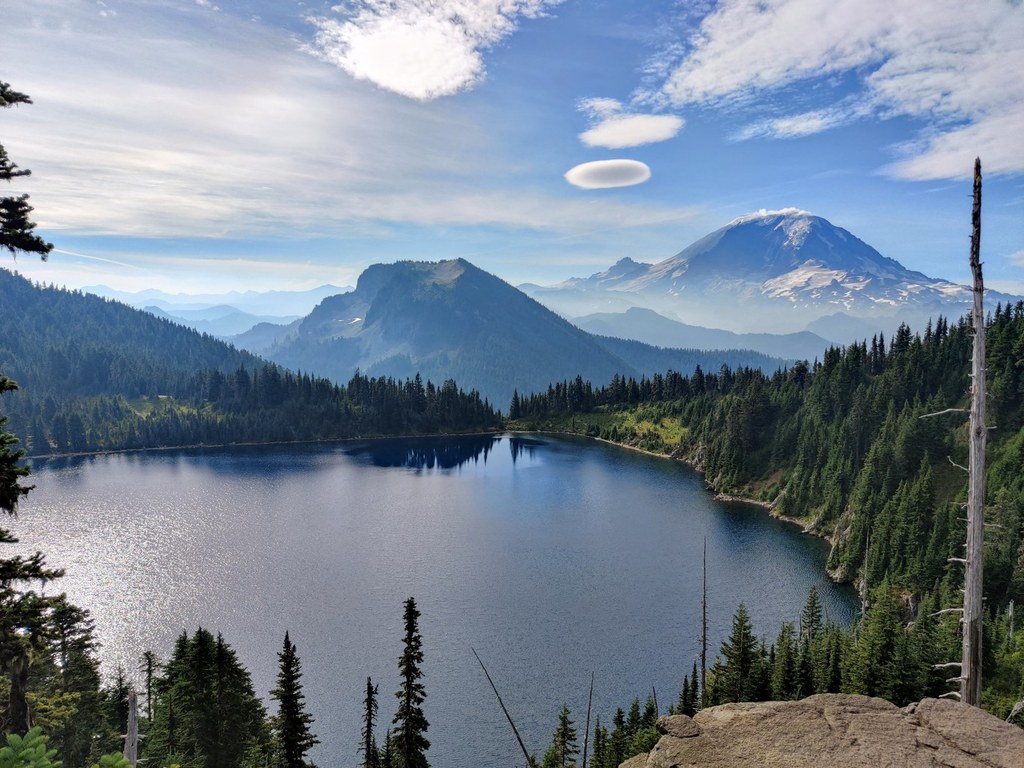
The side trail to the Summit Peak is rough, steep and narrow, but the rewards are worth the extra effort. From the top, the deep blue of Summit Lake competes with the white flanks of Mount Rainier. Beyond that, an ocean of mountaintops spreads out in every direction, with far too many peaks to name.
Backpacking Tip: There are several campsites available around Summit Lake on the NE side and S sides of the lake, offering up more exploration opportunities on the nearby Carbon River and Bearhead Mountain Trails. Note that campfires are prohibited in the Summit Lake basin. And please use the wilderness toilets to go to the bathroom.
Summit Lake

-
 Length
- 6.1 miles, roundtrip
-
 Elevation Gain
- 1,300 feet
-
 Highest Point
- 5,800 feet
The Fairfax Bridge (3 miles south of Carbonado) is closed to all vehicle and pedestrian traffic until further notice due to safety concerns. The bridge closure renders this hike inaccessible.
This popular summer trail offers wildflower-filled meadows, a glistening alpine lake, big mountain views and wildlife sighting aplenty.
Continue reading
Hiking Summit Lake

WTA worked here in 2025, 2024, 2017, 2016 and 2015!
Map & Directions
 Trailhead
Before You Go
The Fairfax Bridge (3 miles south of Carbonado) is closed to all vehicle and pedestrian traffic until further notice due to safety concerns. The bridge closure renders this hike inaccessible.
Parking Pass/Entry Fee
Northwest Forest PassWTA Pro Tip: Save a copy of our directions before you leave! App-based driving directions aren't always accurate and data connections may be unreliable as you drive to the trailhead.
Getting There
From Enumclaw drive west on State Route 410 (Chinook Pass Highway) to SR 165. Proceed on SR 165 to the Carbon River Road/Mowich Lake Highway junction. Turn left onto Carbon River Road and follow it to Cayada Creek Road (Forest Road 7810), just before the national park entrance. Turn left (north) and drive about 6.8 miles to the trailhead at the end of FR 7810.
The final push to the trailhead is a very rough road. It's best to have a high-clearance car if you are hoping to get all the way to the trailhead.