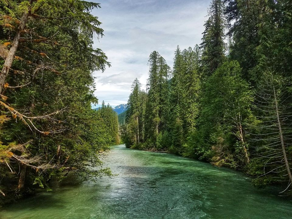
|
Copyright © Craig Romano/The Mountaineers Books Thunder Creek
Hike one of the deepest, wildest, and most accessible wilderness valleys in the North Cascades National Park Complex. Let Thunder Creek's incessant bellowing woo you into this primeval pocket. Enjoy scenic creekside resting posts perfect for whiling away the afternoon. Admire ancient cedars and towering firs and, from holes in the thick forest canopy, gaze out to jagged peaks cloaked in glacial ice. And while the surrounding high country is blanketed in white, enjoy this hike early or late in the season thanks to its low elevation.
A large information board greets you at the trailhead and it's worth a gander before setting out up the valley. Yes, this is cougar country and necessary precautions should be exercised. But for your first mile or two, you'll probably need to be more concerned with saying hello to the throngs of people who venture out from the campground. The wide, smooth trail immediately enters an impressive stand of old-growth forest. Hugging the thickly forested shore of Thunder Arm, an aquatic protrusion of Diablo Lake, the trail passes the Thunder Woods Nature Trail, a recommended diversion. On still mornings and evenings, catch glimpses of emerald ridges reflected in the placid turquoise waters of Thunder Arm. Continue on a near-level course under giant firs and cedars and past big boughs of ferns, reaching Thunder Creek in about 1 mile. Soon new tread is encountered where the trail was rerouted in 2004. The old steel suspension bridge that once crossed Thunder Creek and that many hikers thought was sturdy and reliable evidently wasn't. The destructive floods of 2003 claimed this span along with many others throughout the Cascades and Olympic Mountains. Continue alongside the west side of the creek, passing several inviting gravel bars. At 2 miles the trail comes to a new bridge. Pass through Thunder Camp, set in a centuries-old grove of behemoth firs. Leaving the riverside, the trail now travels through a much younger forest and at 2.5 miles comes to a junction with the Fourth of July Pass Trail. Proceed right, cross a creek, and in 2.8 miles come to a junction with a short side trail that drops back to the river, landing in Neve Camp-a nice place to call it quits if you're content not to carry on. Those inclined to experience more of the Thunder Creek valley can continue following the trail deeper into the wilderness. The thundering waterway is nearby the trail, always audible but not seen. Undulate between old-growth groves and younger forests that are replacing stands scorched by fires over the last few decades. Enjoy periodic openings in the dense canopy and impressive views of the array of towering peaks that line the valley. Their extensive glacial systems help feed the roaring creek beside you. At 6 miles and only 1900 feet elevation, come to the junction with the side trail to McAllister Camp. This is a good place to call it a day, though you may still want to push the 0.5 mile to the camp to get a good glimpse of the narrow gorge where McAllister Creek roars into Thunder Creek. Savor the wildness. Return when you must.
Driving Directions:
From Marblemount follow the North Cascades Highway (State Route 20) east for 24 miles. Just past milepost 130, turn right into the Colonial Creek Campground and proceed 0.5 mile to the trailhead, near the amphitheater at the day-use area (elev. 1250 ft). Water and restrooms available. Recent Trip Reports
Hiked here recently?
Submit a trip report!
There are
40
trip reports for this hike.
See all trip reports for this hike.
Thunder Creek, Fourth of July Pass
— May 12, 2012
— mcm
Day hike
Features:
Wildflowers blooming
Issues:
Blowdowns | Snow on trail | Bugs
Expand report text
Hide report text
Read full report
Left Ballard (Seattle) around 7, arrived Colonial Creek Campgroud just after 9:30 (via I-5 and Hwy 2...
Left Ballard (Seattle) around 7, arrived Colonial Creek Campgroud just after 9:30 (via I-5 and Hwy 20). Gorgeous day. Hiked through the closed campground to the TH proper and on to the junction with Fourth of July Pass.
From here we climbed up about 2,400' to Fourth of July campsite, for a very leisurely lunch break, just below the pass. Snow started just before the camp site but trail was easy to follow. Best views are from the camp site not the pass. Spectalar views through the trees, out to Colonial group, Primus and Triconi. Saw a few other hikers but mostly had this beautiful hike to ourselves. Creek crossings were not a problem, but you may get wet feet if your boots aren't fully waterproof. J was great at spotting wildflowers just starting to show: tiny pink Fairy slippers, Calypso bulbosa; yellow glacier lily, Erythronium grandiflorum; Roundleaf yellow violets, Viola rotundifolia; and, the two trilliums: white and pink. We also saw a few aging false morels along the way. Just a few downed trees to step over on the Fourth of July trail and a few mosquitoes at the trail junction, but none beyond that for now. Back to the cars around 5pm and returned via Hwy 530, making a quick stop at the Pizza handmade bakery cafe (look for small sign on right after the IGA) in Darrington for really tasty apple pie and coffee milkshake. Day hike
Features:
Wildflowers blooming
Expand report text
Hide report text
Read full report
with photos
Wonderful day to hike Thunder Creek Trail. We went in 3 1/2 miles. Trail is in great shape and cre...
Wonderful day to hike Thunder Creek Trail. We went in 3 1/2 miles. Trail is in great shape and creek crossings were very easy. Some wild flowers in bloom along the trail. Seeing this black bear when we were heading back to our car was quite a treat. I've been hiking the North Cascades for 10 years and this was the first time I've seen a bear.
Day hike
Features:
Wildflowers blooming
Expand report text
Hide report text
Read full report
with photos
My hikes so far this year have been primarily lowland hikes. They've been enjoyable, but I've been ...
My hikes so far this year have been primarily lowland hikes. They've been enjoyable, but I've been getting the itch to get out into "real" mountains. After reading several trip reports about Thunder Creek, I decided that it fit the bill nicely. Too low in elevation to satisfy my increasing longing for the high country, it nevertheless has that nice, deep-in-the-wilderness feel.
What a glorious day it turned out to be. It sure didn't feel like May out there, more like August! The one clue that is wasn't August was the scent. The air was so fresh, so clean, so pure, you just wanted to bathe yourself in it. It was refreshing, and oh-so-peaceful out there. At these elevations, the forest is fully in Spring-mode. The leaves are out on the tress, the ferns have unfurled, and the early wildflowers are out. Especially surprising to me were the calypso orchids. I always think of these guys as beign somewhat elusive, but there were scores of them along the trail! I went as far as the junction to McAllister Camp. I didn't see anyone else on the trail until I was almost back in to the car. There, I saw two groups for backpackers headed in. I felt a twinge of jealousy. No snow or intractable mudholes to deal with. The creek crossing right after the McAllister Stock Camp involves either tromping through an 8" deep creek or slithering across an iffy, wet, slippery log.
Thunder Creek, Fourth of July Pass
— May 05, 2012
— Theresa
Overnight
Issues:
Blowdowns | Snow on trail | Bugs
Expand report text
Hide report text
Read full report
Headed out early Saturday morning, picked up our back country permit in Marblemount and were on the ...
Headed out early Saturday morning, picked up our back country permit in Marblemount and were on the trail by 9am or so. We headed up the Thunder Creek trail to McAllister Camp. The trail is close to 100% melted out, but there are some blowdowns. We took off our boots to wade across McAllister creek since there were only slippery logs to walk on and somewhat deep water. Saying it was cold is a total understatement.
We were the only folks camping at McAllister camp and we only saw one other person on the trail on Saturday. There were a few sprinkles, but for the most part it was sunny and warm. I thought it was crazy we had the place to ourselves! There were mosquitoes out in this area, so we were glad we brought our DEET. After we set up camp, we headed up to Tricouni camp to check it out. It was nice, but I think McAllister was a good choice. We had a little beach to ourselves with a waterfall across the river. All the way to Tricouni is melted out also. On Sunday we packed up and decided to make a detour to check out Fourth of July pass. We had some better views of the peaks on the way up. Snow started at about 3300 feet and we decided to turn back after finding a nice ledge to check out the views. We heard from a couple that most of the camps are melted out at Fourth of July camp, but that they didn't see footprints in the snow past the camp towards the pass. This is a very pretty area for some shoulder season backpacking. There are only peak a boo views of the great peaks around, but the mossy forest and greenish river are very beautiful. Day hike
Issues:
Blowdowns | Mudholes | Water on trail
Expand report text
Hide report text
Read full report
with photos
I hiked up Thunder Cr to Tricouni Camp. The trail is in marvelous shape, with minimal mud holes/wate...
I hiked up Thunder Cr to Tricouni Camp. The trail is in marvelous shape, with minimal mud holes/water on the trail. There are ~25 blow-downs from the trail-head to McAllister Camp, with an additional 5 to Tricouni. None are too difficult to get over/under. There is patchy snow starting 1/4 mi beyond the national park boundary and then peters out 1/4 mi before Tricouni. The bridges over Thunder Cr at McAllister Camp and Fisher Cr at Tricouni Camp are in immaculate condition. Cheers!
S-H-A-L |
![]() Thunder Creek Bridge at McAllister Camp. Photo by George Chambers.
Map it
|
Document Actions
- Email this page
- Print this
- Share


