Hike to an old fire lookout with in-your-face views of Mount Rainier and a sapphire blue lake below. Tolmie Peak and Eunice Lake pack a one-two punch when it comes to scenery, but stopping at the picturesque lake is a perfectly acceptable destination as well.
From the parking area at Mowich campground, set off around the west side of big, calm Mowich Lake. Take note, this is a great spot to take a quick dip once you're back from your outing. Follow the trail through open lowland forest along the west side of the lake, gaining elevation gradually, and then on increasingly steep grade as you move away from the lake up to tiny Ipsut Pass nearly two miles from the trailhead. This pass is part of the Wonderland Trail – look down the other side of it to get an idea of how steep sections of this iconic trail are.
Keep left at the pass and continue another 0.8 miles to big blue Eunice Lake. Bugs can be a bother here, but if they're absent (or you don't mind) stick around for a snack and a rest, or make this your destination for the day. Just be careful not to trample the fragile meadows around the lake.
If you want grand views of Rainier, continue past the lake for the final uphill grind. It's a steep mile to Tolmie Peak, and the trail curves around to the north side of the peak for views of the peaks and valleys north, including the large Carbon River Valley before delivering you to your destination.
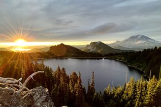
Turn your attention to the large mountain visible to the south. Rainier is huge from this vantage point, and Eunice Lake glittering at the bottom of Tolmie Peak makes for a fantastic photo from here.
WTA Pro Tip: While Tolmie Peak and Eunice Lake are picturesque in the extreme, you'll have to get your sunrise or sunset photos via dayhike. This area is closed to overnight camping. Try getting your alpine start from the Mowich Campground at the trailhead for this hike.
Tolmie Peak Lookout - Eunice Lake

-
 Length
- 7.5 miles, roundtrip
-
 Elevation Gain
- 1,100 feet
-
 Highest Point
- 5,900 feet
The Fairfax Bridge (3 miles south of Carbonado) is closed to all vehicle and pedestrian traffic until further notice due to safety concerns. The bridge closure renders this hike inaccessible.

Parking Pass/Entry Fee
National Park Pass
Hike to an old fire lookout with in-your-face views of Mount Rainier and a sapphire blue lake below. Tolmie Peak and Eunice Lake pack a one-two punch when it comes to scenery, but stopping at the picturesque lake is a perfectly acceptable destination as well.
Continue reading
Hiking Tolmie Peak Lookout - Eunice Lake
Map & Directions
 Trailhead
Before You Go
The Fairfax Bridge (3 miles south of Carbonado) is closed to all vehicle and pedestrian traffic until further notice due to safety concerns. The bridge closure renders this hike inaccessible.
Parking Pass/Entry Fee
National Park PassWTA Pro Tip: Save a copy of our directions before you leave! App-based driving directions aren't always accurate and data connections may be unreliable as you drive to the trailhead.
Getting There
From Puyallup, drive east for 13 miles on Highway 410 to the small town of Buckley. Turn right onto Highway 165 and continue through Carbonado. You're looking for Mowich Lake Road, which is beyond the Carbon River Gorge bridge, right outside of town.
Turn right onto Mowich Lake Road and follow it about 17 miles to its end. Note that this road is dirt, and can be rough. Consider bringing a high-clearance vehicle, though sedans are sometimes able to make it. The trailhead is on the left side of the road, near Mowich Lake.