Stats
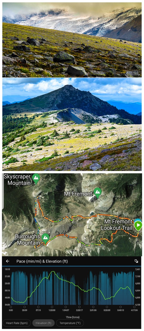
- Distance: 9-1/2 miles
- Vertical: 2125 feet
- Duration: 4-1/4 hours
- Weather: variable; cloudy/foggy, chilly with strong winds over ridges, to some sunny periods
- Takeaway: Great loop trail with route-finding and scrambling skills and GPS required for the rough section from the 2nd/3rd Burroughs pass to Skyscraper Pass. Wonderful variety of terrain and views across this route.
Started at Sunrise. Plenty of parking here, as well as all major trailheads on Sunrise Road.
I decided to link together some trails, and a section that cannot really be called a "trail", to form a loop hike: Sunrise Rim to 1st Burroughs, Burroughs Trail to the pass between 2nd/3rd Burroughs, a "boot path" from this pass to Skyscraper Pass, Wonderland trail to Frozen Lake via upper Berkeley Park, and Sourdough Ridge back to Sunrise. As you can see from my stats and the Garmin snapshot below, the route is fairly moderate with up and down sections. However, there is one section connecting the Burroughs to Skyscraper Pass that has some exposure and scrambling required, and a wrong route choice (which we almost made) could be dangerous.
The day started cloudy as I headed out on the Sunrise Rim trail. I had not done this trail in a while (previously as part of a loop out of White River Campground up to the Burroughs). The trail is etched into a rock cliff, at times with a rock wall separating you from the valley far below. You can see the terminus of the Emmons glacier, some milky green lakes, and the hiking area up to Glacier Basin. We were socked in, but no real wind at this point. Eventually you climb up the backside (relative to the approach from Frozen Lake) of 1st Burroughs, and the fog/wind offered a brutal embrace as I crested the summer. I had visions of being on a swaying chair at Snoqualmie Pass in a whiteout with the wind howling. Windbreaker - on. Thoughts - how much Merino wool is in my backpack?
Climbed to 2nd Burroughs which usually has incredible views, but we were still socked in, and I had to describe what the view would normally look like for some of the tourists perched there patiently waiting for a sunny period (you kind of feel bad, but this is WA and everyone else in the country thinks it is this way all the time!). Descending from 2nd Burroughs, one reaches the start of a boot-path, roughly at the junction of trails to 3rd Burroughs and down to Glacier Basin.
The trail is faint - non-existent at some points - with a lot of rock and pumice. One of course needs to respect the fragile environment and stay on solid rock as much as possible. The destination - Skyscraper Pass - is visible pretty early far (?... at least it seems at this point) in the distance. For the most part, the trail hugs the rim of the Burroughs cliff/precipice dropping into Berkeley Park basin. Eventually, one comes to what seems like a dead end with steep drop offs and rocky outcropping above basin rim, and blocking the way forward. I had loaded the waypoints (available online), but still almost went the wrong direction (OK, "Guide Me" is not idiot proof). Going right looks very exposed, but there seemed to be trail. NOT A TRAIL, as I would later realize looking up at the basin rim from the Wonderland trail through upper Berkeley Park. Instead, the trail dips down to the left and you scramble down a slope of stunted trees and large boulders, never quite clear how you will end up connecting back with the Skyscraper Ridge trail you have seen for some time at a distance. The trail descends quite a bit to bypass the cliffy/rocky outcropping section. At the bottom, you actually have to ascend UP to get up to Skyscraper ridge trail. Slow and methodical... no problem (ok... I fell once... but the camera was OK which is all that is important).
I decided to do the loop clockwise. With this routing, the connector between the Burroughs and Skyscraper pass is roughly 650 feet down, and 150 feet up. I think if I had gone counterclockwise, the route might have been more obvious - definitely would not have considered the cliff area to the right! I also find it easier to ascend boulder areas. But, it was easy to look DOWN the way I went to see the fair outline of a trail.
Skyscraper Pass has beautiful views of Rainier and 3rd Burroughs. You can also see Emmons, Winthrop and Carbon glaciers at the same time - very cool. The descent on the Wonderland trail through upper Berkeley Park was as beautiful as my recent trip, except this time the herd of roughly 50 goats I saw from a distance on my Fremont Lookout hike, was blocking the trail back to the car!
I approached slowly, and the goats moved off the trail (thanks guys) although not really that far away. No worries... I paid attention to any signs of aggression and we were all cool with one another. The alpha male was busy giving himself a "dirt shower" (kind of captured in a picture below) and did not pay much attention to me :)
The trip back to Sunrise was uneventful although the cloud//fog was rapidly returning, so waiting for sunset pics was out of the question for me!


Comments