

The landscape atop Burroughs is both broad and barren, so there is little to inhibit full exposure. Seemingly little plant life should survive this harsh, high-elevation terrain, yet the number of wildflower varieties that thrive with vibrant color on this hike may surprise you. Besides the floral displays in early summer, the wildlife seen atop this summit is a treat. Goats wander the hillsides, and chipmunks, marmots and pika skitter amongst the rocks, along the trail and atop each of the three “peaks” which define this long, tundra-like alpine mountain.
The trail can be accessed from the northwest corner of the Sunrise parking lot. Note that despite warm weather in the parking lot, there is often a snowfield into the early summer on the approach to First Burroughs. Assess the situation, and use great caution with steep snow travel. If you feel unsure about the crossing, save the hike for later in the season.
Follow the signs to the top of Sourdough Ridge on a wide, often dusty trail. The trail heads steadily uphill, gaining 400 feet in just over half a mile. The way is well-marked and heads west to a five-way intersection at Frozen Lake. From here, follow the Burroughs Mountain Trail as it makes its way uphill to the southwest on a relatively steep stretch of trail, reaching the broad, open top of First Burroughs Mountain at roughly 7,000 feet.
Continue past an intersection to Second Burroughs, climbing an additional 400 feet in about half a mile. Second Burroughs offers impressive views into the Glacier Basin below, pointed Little Tahoma on a ridge of Rainier to the south, and expansive views of the park to the north, including Fremont Lookout, Berkeley Park, Grand Park and Skyscraper Mountain. With the elevation gain and mileage, Second Burroughs is a good turnaround point for most day hikers. But those after a bigger adventure can continue downhill to a saddle and intersection with the Glacier Basin trail.
If you're tempted by the swell of Third Burroughs, do it! It’s worth it if you have gas in the tank, and the data listed for this trail refer to a hike all the way to Third Burroughs. Round trip, you're looking at another 3 miles (9 miles total for a full hike to Third Burroughs; it's 6 for Second). And you add 1,155 feet more cumulative elevation gain to your trip (it's 1,345 feet of elevation gain for Second Burroughs).
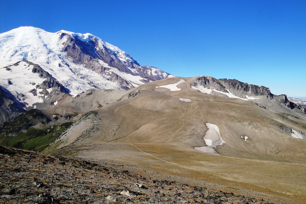
Stay on the trail, which veers slightly right and climbs the bench that eventually leads to the high point: Third Burroughs Mountain. Extra effort is required to reach the 7,800-foot rocky top, but the reward is the invigorating feeling of being so close to Mount Rainier that you could reach out and touch it
Stay a while on the top of Third Burroughs. There are plenty of big, flat rocks on which to sit and listen to the sounds of rock fall and the groaning mountain. Peek over the edge to the west and count the crevasses in the Winthrop Glacier formed along the contour of this volcano. Study the Inter Glacier for tiny climbers making their way to Camp Schurman and the eventual summit. Enjoy the views; they are stunning!
WTA Pro Tip: This area can be done as a loop. Access the trail using a trailhead on the south side of the Sunrise parking area. Travel in a clockwise direction and pass Shadow Lake on level trail, then climb sharply to an overlook on the White River and Emmons Glacier.
Beyond the overlook, the route continues up and onto the wide, flat plateau of First Burroughs Mountain, reaching the aforementioned five-way intersection at Frozen Lake. Here, you can continue on to Second Burroughs using the above directions, or hike east another 1.4 miles back to the Sunrise parking lot in a loop.
 Trailhead


