
The Mima Falls Loop takes hikers through young plantings, lush forest, and quiet wetlands in Olympia's Capitol State Forest. Just 30 minutes from the state capital, this is the perfect year-round waterfall hike for after work or weekends. Hike through a working forest and examine forestry practices up close.
On a packed summer day the parking lot can hold 30 cars. Pass by the kiosk and mounting ramp to leave the Mima Falls trailhead and enter the first planting.
A quick glance of this section may seem uninteresting, but closer examination of the plot yields evidence of silviculture practices, including site preparation, tree spacing, species, and felling techniques.
Cross the E-9000 road, and the trail enters a much older forest. Epiphytes-- ferns and mosses--grow thick on maples and firs. The understory is a lush mix of elderberry, salmonberry, trillium, and lady fern.
Walk through another young planting and back under the canopy, past lush wetlands. 1.5 miles from the last junction, reach another one, this between Mima Falls West and the Mima Falls Tie trails.
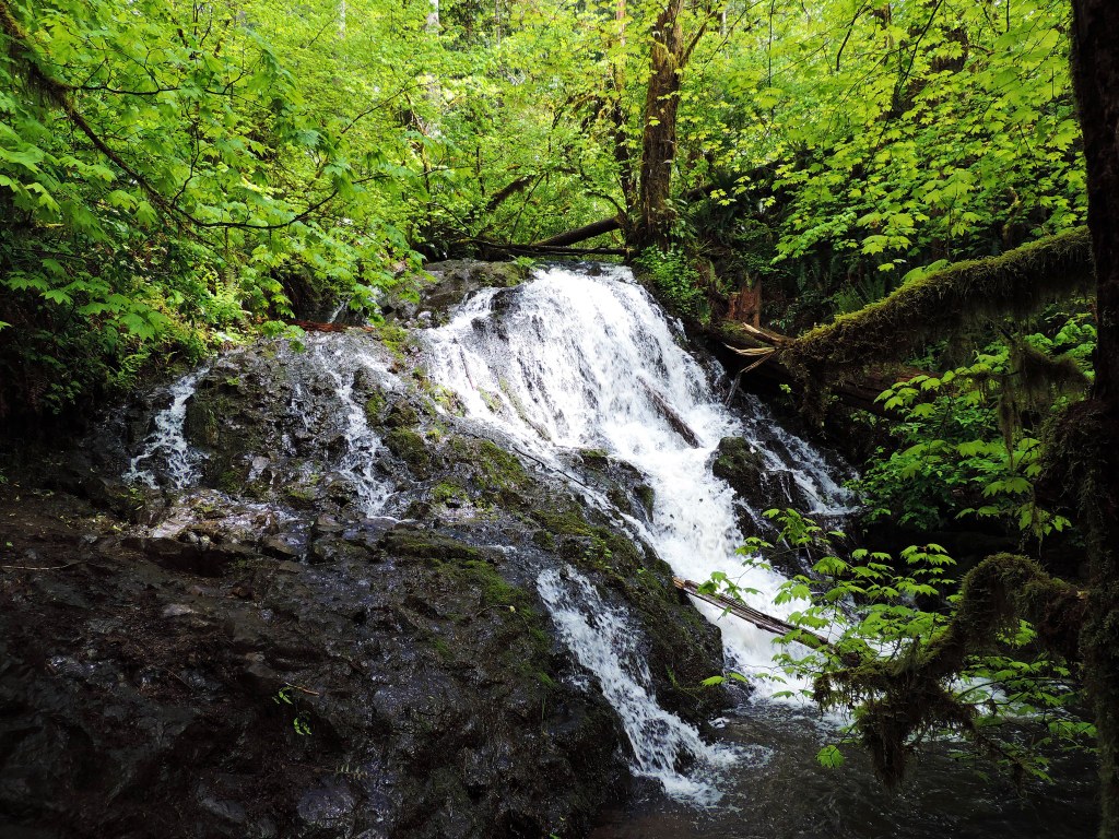
To reach Mima Falls in a half mile, take the Mima Falls West trail. Complete with picnic table, the falls is a great place to take lunch and cool down. A small bridge crosses above the falls, but be sure to find the trail that leads to the viewpoint at the bottom.
Double back to the junction between Mima Falls West and Mima Falls Tie trails and this time, take the Mima Falls Tie. From here, the trail rises and falls from the canopy within a mile.
Cross the E-9000 road again and come to another junction near a big culvert on the roadside. Follow the Campground trail and begin the journey back down. Here the trail winds alongside open wetlands lined by ferns of every kind--sword, lady, bracken, maidenhair, and licorice.
1.9 miles after the junction of Mima Falls Tie and Campground trail, return to the junction of the Campground and the Mima Falls East trails. Follow Mima Falls East trail for 0.5 miles SSE to end up back at the trailhead.
Be sure to bring a map and compass to navigate the endless possibilities of equine loops, roads, and hiking trails around the falls. Combine Mima Falls East and West trails for a 15-mile day of exploring Capitol State Forest.
Note: This area is a working forest and certain trails may be temporarily closed due to logging operations. Check trip reports below for the latest information.
WTA Pro Tip: The Littlerock Grocery, on the corner of Maytown and Littlerock Roads, sells the DNR trail map of Capitol State Forest. They also have plenty of fried food for the drive home.
Capitol State Forest - Mima Falls Loop

-
 Length
- 5.5 miles, roundtrip
-
 Elevation Gain
- 600 feet
-
 Highest Point
- 650 feet
The Mima Falls Loop takes hikers through young plantings, lush forest, and quiet wetlands in Olympia's Capitol State Forest. Just 30 minutes from the state capital, this is the perfect year-round waterfall hike for after work or weekends. Hike through a working forest and examine forestry practices up close.
Continue reading
Hiking Capitol State Forest - Mima Falls Loop
Map & Directions
 Trailhead
Before You Go
Parking Pass/Entry Fee
Discover PassWTA Pro Tip: Save a copy of our directions before you leave! App-based driving directions aren't always accurate and data connections may be unreliable as you drive to the trailhead.
Getting There
From I-5 South: Take exit 95 and continue onto Maytown Road SW for 2.8 miles. Maytown Road becomes 128th Ave. Continue on it for 0.7 miles to a 'T' intersection. Turn left onto Mima Road SW and continue for 1.3 miles. Turn right onto Bordeaux Road SW for 0.6 miles. Turn right onto Marksman Street SW. After 1 mile keep straight at the bend in the road. Follow the gravel loop until you reach the parking lot and trailhead.


