
Here's a great backdoor access to Mount Townsend. You’ll likely have company at the summit, but this route offers solitude to get there, along with some sweeping views, plus steeps to work those quads! Consider why it's so infrequently used -- a sign at the trailhead warns of grades up to 40% in places! It's short, but there's nothing sweet about it.
Park at the Tubal Cain trailhead and walk up the road to a trail signed “Little Quilcene Trail #835” on the left. Not one to lull you into a false sense of ease, the trail starts off climbing steeply and stays that way for two miles. It's a burner, to be sure. Just before the junction with the Mount Townsend trail, break out onto a ridge and take in your first of many expansive views.
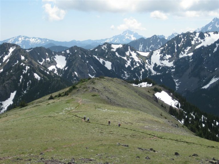
Catch your breath and look for the Tubal Cain trail across the valley before dipping back into forest before arriving at a signed junction 2.3 miles in. Here, leave the Little Quilcene Trail, proceeding straight on the trail signed for Mount Townsend. You'll hike through subalpine forest and wide open talus slopes dotted with shrubs as you progress 2.4 miles to the summit of Townsend. Your progress is still upward, but at a much more merciful grade than the previous two miles. Just past the wilderness boundary is a fork in the trail. Either one gets you to the summit, but the right-hand trail is a more direct route.
If you take the left fork, you’ll reach the second summit first, then continue to the first, generally more peopled summit. Either high point is an ideal spot to dump your pack and enjoy a leisurely lunch while taking in the panoramic views of Olympics, Hood Canal, Cascades, Strait of Juan de Fuca, Port Townsend, Seattle, and more.
WTA Pro Tip: This is just one of several ways to reach the summit of this popular mountain. The more popular main Townsend trail is more forgiving, but the Little River Trail (which you passed on the way up) is just about as much of a burner as this one. Check out a map for some nice loop options using all these access points.
Dirty Face Ridge

-
 Length
- 7.5 miles, roundtrip
-
 Elevation Gain
- 3,000 feet
-
 Highest Point
- 6,280 feet
12.29.25: FR 2880 has a rockslide 0.5 mile past Dungeness Forks Campground (before the junction with FR 2870) on the road. Trails are still accessible via FR 2870.
Here's a great backdoor access to Mount Townsend. You’ll likely have company at the summit, but this route offers solitude to get there, along with some sweeping views, plus steeps to work those quads! Consider why it's so infrequently used -- a sign at the trailhead warns of grades up to 40% in places! It's short, but there's nothing sweet about it.
Continue reading
Hiking Dirty Face Ridge
Map & Directions
 Trailhead
Before You Go
12.29.25: FR 2880 has a rockslide 0.5 mile past Dungeness Forks Campground (before the junction with FR 2870) on the road. Trails are still accessible via FR 2870.
Parking Pass/Entry Fee
NoneWTA Pro Tip: Save a copy of our directions before you leave! App-based driving directions aren't always accurate and data connections may be unreliable as you drive to the trailhead.
Getting There
From the west end of the Hood Canal Bridge, drive State Route 104 to its end and veer north onto Louella Road. In one mile turn left on Palo Alto Road, continuing for six miles. Bear right at a junction onto Forest Road 2880. The road descends and crosses the Dungeness River, coming to another junction in 1.7 miles, where you turn left on FR 2870. In 2.6 miles bear right at a junction to continue on FR 2870. Drive 10 miles to the Tubal Cain Trail parking area. The trail is located on the left 0.15 mile farther along FR 2870.


