Trails for everyone, forever

Home Go Hiking Hiking Guide Dodger Point

Alert: On Oct. 1 the federal government began a partial shutdown that will impact National Parks, National Wildlife Refuges and U.S. Forest Service lands in Washington. Here's the latest information we have for hikers and campers


Dodger Point

Olympic Peninsula > Northern Coast
48.0409, -123.5903 Map & Directions
Length
39.0 miles, roundtrip
Elevation Gain
10,815 feet
Highest Point
5,670 feet
Calculated Difficulty About Calculated Difficulty
Hard
Mount Olympus at sunset from Dodger Point lookout. Photo by Eric Nagle Full-size image
  • Dogs not allowed
  • Established campsites
  • Mountain views
  • Summits

Parking Pass/Entry Fee

National Park Pass
Saved to My Backpack

Backpack on primitive trails to Dodger Point Camp in the heart of Olympic National Park for unparalleled views of high, snowy peaks towering above deep forested valleys. Continue reading

Rating
3.60 out of 5

(5 votes) Log in to rate

Hiking Dodger Point

The last of its kind, this lookout in the heart of Olympic National Park offers unparalleled views of high, snowy peaks towering above deep forested valleys.

To backpack it, start at the Madison Falls trailhead, the last accessible trailhead before the road washout closure. The first 6 miles are on the old Olympic Hot Springs Road and up the Whiskey Bend Road to the old Whiskey Bend Trailhead, a relatively mild hike — at least, compared to the next part of your hike. 

From the old trailhead, start on easy grade along the Elwha River Trail for 2 miles to Michael’s Cabin. Fork right on the Long Ridge Trail and continue along the forested hillside to the crossing of the Elwha River. Top off all of your water here, as this will be your last source until reaching the tarns below Dodger Point.

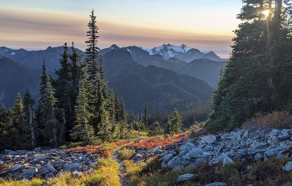
Aptly named, the Long Ridge Trail travels the eastern slope of the ridge through stands of second-growth forest that were subject to a series of burns between 1897 to 1941. As you climb by way of long, sweeping switchbacks, frequent openings present views of the Grand Canyon of the Elwha, up to a saddle at the ridgetop. Here, the trail crosses over to the western slope and traverses above Long Creek. The Bailey Range—dominated by Mount Carrie and Stephen Peak—is visible to the west. The route then enters a stretch of subalpine forest before opening into meadows marked with mountain hemlock. Hurricane Hill is directly north.

Contouring the west slope, Mount Olympus comes into view, partially hidden by the Bailey Range. Nearing your destination, round the western side of Dodger Point, where the trail crosses a series of alpine meadows dotted with snowmelt tarns, then makes a steady climb to the Dodger Point camping area. Just beyond, a trail junction at a low spot on the ridge forks left and climbs the last half-mile to reach the lookout.

Built in 1933, the point was named after “Dodger” Bender, the first lookout to man the building. The best views are found just below the lookout, highlighted by Mounts Dana, Wilder, Christie, Scott and Barnes and all the way down the Hayes River Valley to Mount Anderson. Mount Olympus dwarfs the closer peaks of the Bailey Range.

WTA Pro Tip: You will need an Olympic wilderness permit for camping and Little D's Woodfired Grill in Port Angeles is the place to stop for tasty pizzas, hearty meals and cold brews post-hike.

Toilet Information

  • No toilet at trailhead

More information about toilets

Hike Description Written by
Kelsie Donleycott, WTA Correspondent

Dodger Point

Map & Directions

Trailhead
Co-ordinates: 48.0409, -123.5903 Open in Google Maps

Before You Go

Road closed: The Olympic Hot Springs Road is inaccessible to vehicles due to a washout. Data for this route reflect a hike starting at the Madison Falls trailhead which is the last accessible trailhead before the washout.

See weather forecast

Parking Pass/Entry Fee

National Park Pass

WTA Pro Tip: Save a copy of our directions before you leave! App-based driving directions aren't always accurate and data connections may be unreliable as you drive to the trailhead.

Getting There

Headed west on Highway 101 from Port Angeles, drive 8.5 miles and turn left onto Olympic Hot Springs Road (just before the bridge over the Elwha River). Continue down Olympic Hot Springs Road, until you reach the park entrance gate. Buy a pass, (or flash one if you already have one) and park at the Madison Falls trailhead.

Note: This is currently  and will indefinitely be  as far as a vehicle can go on Olympic Hot Springs Road due to flood damage.

More Hike Details

Trailhead

Olympic Peninsula > Northern Coast

Olympic National Park

You can improve or add to this guidebook entry!

Dodger Point

42 Trip Reports

Hiked here recently?

Submit a trip report!
 
Trip Reports