

Spring, summer, and fall all beckon hikers up the slopes of Delancy Ridge toward Driveway Butte, attracted by the views, seasonal flowers, or just a hard workout. The trail tells the tale to two forests, a mature pine forest in the first half and a forest recovering from fire in the second.
From the trailhead, elevation 2950 feet, the trail is a gradually steepening hike through the mature forest with a slightly brushy understory and spring flowers. The switchbacks get close to Indian Creek, which is heard, but not seen. The shady forest is left behind on a steep hillside traverse, which opens a view of Silver Star Mountain and others at 1.2 miles (elevation 4000 feet).
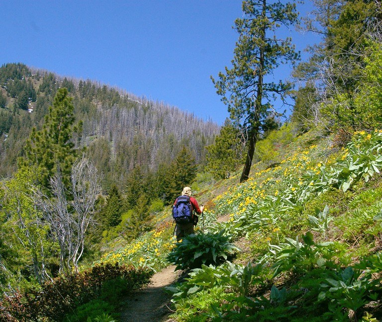
The next 0.7 miles crosses open slopes in a steady, sunny climb, where, the spring flowers and views provide a great distraction from the effort. The few old pine trees along the way provide moments of shade.
Back into the mature forest, hints of the fire effects are seen with an increasing number of burnt logs. This reduces the shade and opens the views, but don’t get fooled by the apparent pass just ahead. The actual pass between Indian Creek and McGee Creek is a few hundred feet higher.
At 2.2 miles from the trailhead (elevation 4900 feet), the grade relents substantially and the mature forest is essentially gone. The surroundings are a silver forest, with an understory of large “pickup stick” logs, young pines, and willow brush. This is the aftermath of the 2003 Needle Creek Fire.
This location is also a decision point for hikers, as there is an unmarked junction with an informal trail to the right (northeast). The informal trail leads to the viewpoint in 0.8 mile, (elevation 5545 feet), with great views. The formal trail continues straight into the old burn, where trail conditions will vary substantially with season and recent trail maintenance.
From the unmarked junction, the next 1.8 miles crosses the head of Indian Creek (muddy trail) and does a gradual climbing traverse through the burn around the headwaters of McGee Creek. The traverse crosses 4 seasonal creeks with various amounts of mud. Depending upon recent maintenance, this section may have many logs to go under, over, and around. Long pants and sunglasses can be a protection asset from the broken branches, brush, and young trees.
Once back into the open at elevation 5460 feet, the trail crosses the last seasonal creek. A somewhat faint trail climbs 500 feet in 0.3 mile to reach the lookout site at 4.3 miles from the trailhead, elevation 5982 feet.
A slant-walled cupola lookout was built in 1931 and a tower lookout was built in 1938 to improve the visual coverage. In 1953, both were destroyed and the remnants are primarily tower foundations and rusty nails, along with a reference (with arrow) and benchmark.
All or part of the trip can be done from late March through November. Each season has it’s own considerations.
In March & early April, a parking pullout is plowed out on State Route 20 for Klipchuck Road. A snow trip combines the road to the trailhead, and trail, as far as conditions, equipment, and skill allow.
In April, the McGee Creek headwaters may be snow covered. This can make travel somewhat difficult with thigh deep postholing next to hidden logs on the trail. Most hikers opt for the informal trail to the viewpoint in this season.
The ideal time is late May to early June, when the trail is mostly melted out and the flower show is in full bloom. Be ready for breathtaking views and a workout hike through a flower garden. A morning start is advisable, with plenty of water, given minimal shade and daytime highs in the 70’s at the top.
By mid-July, most of the flower show is fading and the real heat sets in. The primary draw for the rest of the summer are the views, or a workout in 80F to 90F heat! Just be aware that the rattlesnakes tend to be more active in the lower elevations of the trail.
In September, temperatures are dropping and by mid-October the fall coloring dominates the foliage, mixed with a bit of hunter orange. The lower temperatures firm up the muddy Indian Creek headwaters, but after some snow and hiker packing, the trail can be quite firm/slick.
WTA Pro Tip: Some maps show a trail descending the north side of the butte down to the Methow River. This was part of an old sheep driveway that has been abandoned, and the trail is unmaintained and partially non-existent.
 Trailhead


