

The Pacific Crest Trail (PCT) runs from Mexico to the Canadian border through the Columbia Gorge. While it is well-known for traveling along the waterfall-filled Eagle Creek Trail, purists know that it is an alternate route; the actual trail runs a bit south closer to the Bridge of The Gods. Here, the PCT leads you to the secluded gem of Dry Creek Falls just a few miles away from the noise and bustle of I-84.
Parking in the main lot on Harvey Road, look for the large green sign for the Pacific Crest and Gorge 400 Trails across the street and head west on its wide, easy graded terrain. This trail was closed in 2017 due to the Eagle Creek Fire, caution is advised as falling trees, landslides, and debris flows are possible in the burned areas due to less vegetation and unstable soil.
In the spring you will be greeted by burgeoning sword fern fronds, cotton candy pink bleeding hearts, soft blue wood anemone and purple tinted trillium as you slowly trade the din of the cars overhead for the lullaby of the recovering forest bearing the scars of wildfire. In the fall, vine maple provides warm patches of hue in contrast to the cool mossy green boulders left over from long ago volcanic activity. Do keep an eye out; poison ivy has been known to present itself in a few parts of the forest here.
The trail turns south briefly and makes a slow and steady ascent before turning west again around Cascade Knob and under power lines at about a mile into your journey. After connecting with the trail again, you will be guided through the thin forest of Douglas-fir that allows for brief glimpses of the Columbia Gorge summits on your left with streams of sunlight to guide your way. The landscape's volcanic history is evident in the rugged and rocky trail surface, so take care with your steps.
The Pacific Crest Trail skirts along the contour of Manzanita Hill before you begin to make a slight descent from an elevation of 800 feet towards Dry Creek and a junction with an old road that once delivered travelers to the falls two miles in (elevation 710 feet). A sturdy wooden bridge spans over Dry Creek taking hikers into the Mark O. Hatfield Wilderness Area and further south on the PCT up to Benson Plateau but you want to turn right and climb up this old road 0.3 miles and another 250 feet of gain towards the falls. There is a large open area that once was for parking and a small rocky trail continues to the left to deliver you to the basin of Dry Creek Falls (elevation 940 feet).
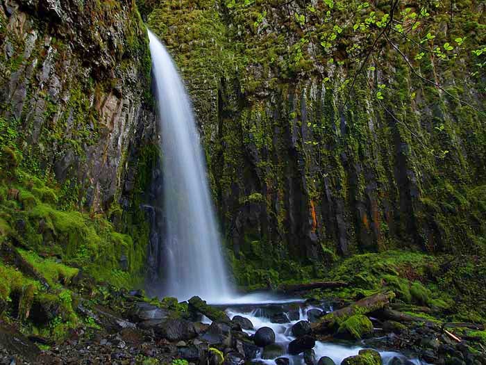
This narrow and dramatic cataract streams down 74 feet from the cleft in the vertical moss and lichen coated slabs of pillared basalt rock that towers above. If you have timed your hike right, colorful rainbows from the day’s sun filter in to dance off the spray that fills this small alcove.
Near the base of the falls, a concrete structure that once used to help provide water to the residents of Cascade Locks crosses over to a viewpoint on the other side but watch your step as the ground is slick with mud and wet angular rock. From here you can see how the water snakes its way through staggered steps in the basalt to eventually pour out into the small pool below. Take some time to sit and enjoy the cooling spray before returning back the way you came. Dry Creek Falls also makes for a perfect low-level winter hike because despite the name, it never runs dry.
If you choose to park at Bridge of The Gods trailhead near the bridge itself, cross the road carefully on the southwest side to a path leading up to the left that parallels I-84 through a sparse strip of trees. In a short distance, you will come to a junction with SW Moody Ave and travel below the underpass of I-84. A large blue and white Pacific Crest Trail emblem painted on one of the columns of the overpass lets you know that you are in the right place. Walk about 100 yards up to the right to the junction with the Gorge Trail 400 and the main parking lot (about .2 miles from your car).
 Trailhead


