Trails for everyone, forever

Home Go Hiking Hiking Guide Elwha River and Geyser Valley

Alert: On Oct. 1 the federal government began a partial shutdown that will impact National Parks, National Wildlife Refuges and U.S. Forest Service lands in Washington. Here's the latest information we have for hikers and campers


Elwha River and Geyser Valley

Olympic Peninsula > Northern Coast
48.0409, -123.5901 Map & Directions
Length
17.5 miles, roundtrip
Elevation Gain
3,570 feet
Highest Point
1,450 feet
Calculated Difficulty About Calculated Difficulty
Hard
View of the Elwha River from Long Ridge Trail. Photo by Kiloa. Full-size image
  • Dogs not allowed
  • Established campsites
  • Old growth
  • Rivers
  • Wildflowers/Meadows
  • Wildlife

Parking Pass/Entry Fee

National Park Pass
Saved to My Backpack

Follow in the footsteps of the intrepid Press Expedition while enjoying the natural beauty, local history and wildlife along the Olympic Peninsula’s Elwha River. Continue reading

Rating
3.17 out of 5

(6 votes) Log in to rate

Hiking Elwha River and Geyser Valley

Follow in the footsteps of the intrepid Press Expedition while enjoying the natural beauty, local history and wildlife along the Olympic Peninsula’s Elwha River.

In the winter of 1889-90, members of the Seattle Press Expedition set off to blaze a trail across the Olympic Mountains. The party spent the first part of 1890 exploring the Elwha River Valley. Today, evidence of the Press Expedition can still be found throughout the valley, both in blaze marks and the names of various natural features.

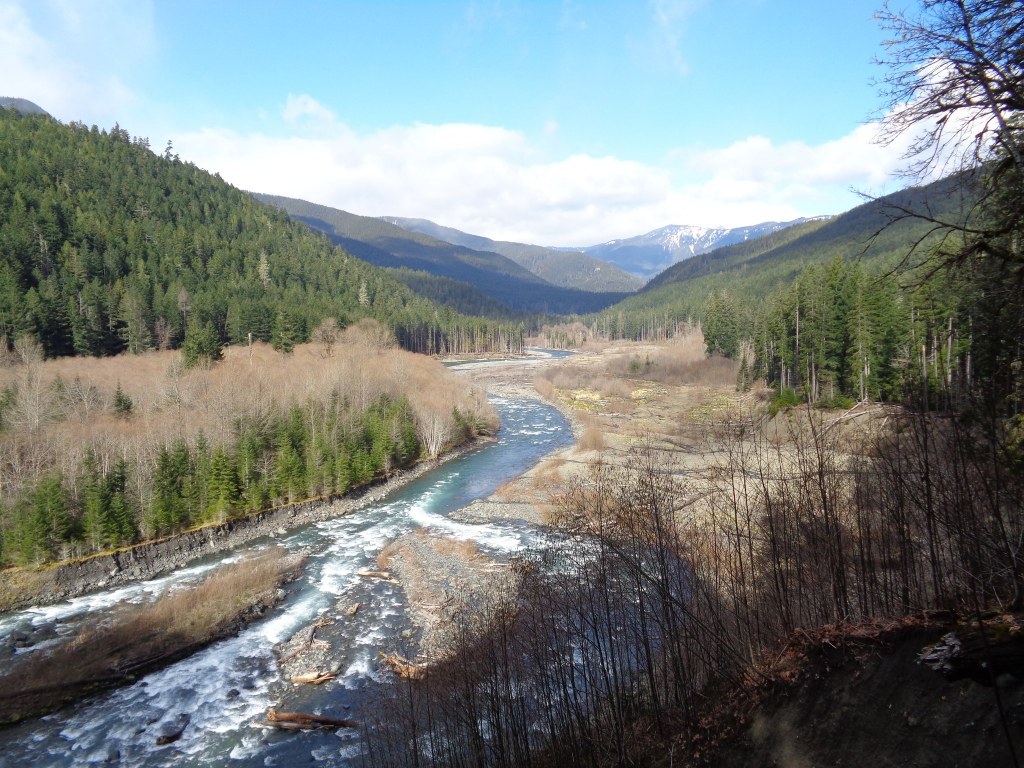
The whimsical name of Geyser Valley can be attributed to "Dok" Ludden, a gentleman who lived in the valley in the early 1900s and built a house in the valley to welcome all visitors. He observed the wind, blowing upriver on the Elwha, blowing the clouds into vertical shapes he called "geysers" and named the valley after this phenomenon.

Start from the Madison Falls trailhead, the last accessible trailhead before the road washout closure. The first 6 miles are on the old Olympic Hot Springs Road and up the Whiskey Bend Road to the old Whiskey Bend trailhead, a relatively mild hike. About 3.5 miles in from the Madison Falls trailhead, stop for a minute at the Glines Canyon Overlook, the site of an old abandoned dam. 

From the old Whiskey Bend trailhead, follow the wide and gentle Elwha River Trail through old-growth forest. In about 1 mile, a short side trail leads to the Eagle's Nest, an overlook of the valley below, and often a good place to see deer, elk and bears. Continue to the junction with Rica Canyon at 1.2 miles and descend towards the river bottom. Prior to entering the wide, flat stretches of Geyser Valley, take a short side trip to Goblins Gate, where the Elwha River crashes through a rocky gorge.

At 2.7 miles, stay right and travel through Krause Bottom. At 3.4 miles arrive at Humes Ranch. Located on a grassy bluff and constructed in 1905, the homestead was once inhabited by mountain man and wildlife photographer Herb Crisler. From here, descend into the grassy meadow below, then up to a junction with the Long Ridge Trail at 4 miles. A 0.6-mile side trip visits the Dodger Point Bridge, which crosses the river at the mouth of Convulsion Canyon, so named by the Press Expedition.

For backpackers, a more direct route to camping near Humes Ranch is reached by following the Elwha River Trail to the junction 0.3 mile past Michael’s Cabin. Turn right and descend directly towards Humes Ranch. Campsites are located below Humes Cabin in the grassy meadow and forest. Camping is also allowed near Krause Bottom.

Hike Description Written by
Kelsie Donleycott, WTA Correspondent

Elwha River and Geyser Valley

Map & Directions

Trailhead
Co-ordinates: 48.0409, -123.5901 Open in Google Maps

Before You Go

Road closed: The Olympic Hot Springs Road is inaccessible to vehicles due to a washout. Data for this route reflect a hike starting at the Madison Falls trailhead which is the last accessible trailhead before the washout.

See weather forecast

Parking Pass/Entry Fee

National Park Pass

WTA Pro Tip: Save a copy of our directions before you leave! App-based driving directions aren't always accurate and data connections may be unreliable as you drive to the trailhead.

Getting There

Headed west on Highway 101 from Port Angeles, drive 8.5 miles and turn left onto Olympic Hot Springs Road (just before the bridge over the Elwha River). Continue down Olympic Hot Springs Road, until you reach the park entrance gate. Buy a pass, (or flash one if you already have one) and park at the Madison Falls trailhead.

Note: This is currently  and will indefinitely be  as far as a vehicle can go on Olympic Hot Springs Road due to flood damage.

More Hike Details

Trailhead

Olympic Peninsula > Northern Coast

Krause Bottom (#00), Geyser Valley (#00), Goblins Gate (#00), Elwha River (#00)

Olympic National Park

Guidebooks & Maps

Day Hiking: Olympic Peninsula (Romano - Mountaineers Books)

Custom Correct Elwha Valley

Buy the Green Trails Hurricane Ridge/Elwha North No. 134S map

You can improve or add to this guidebook entry!

Elwha River and Geyser Valley

80 Trip Reports

Hiked here recently?

Submit a trip report!
 
Trip Reports