Trails for everyone, forever

Home Go Hiking Hiking Guide Gypsy Copper Camp
link

Gypsy Copper Camp

Eastern Washington > Selkirk Range
48.8717, -117.1454 Map & Directions
Length
0.5 miles, roundtrip
Elevation Gain
100 feet
Highest Point
3,468 feet
Calculated Difficulty About Calculated Difficulty
Easy
Restored powder house at Gypsy Copper Camp. Full-size image
  • Dogs allowed on leash
  • Good for kids

Parking Pass/Entry Fee

None

A short hike to an historic mining camp and recently restored buildings on the Colville National Forest. Continue reading

Rating
0.00 out of 5

(0 votes) Log in to rate

Hiking Gypsy Copper Camp

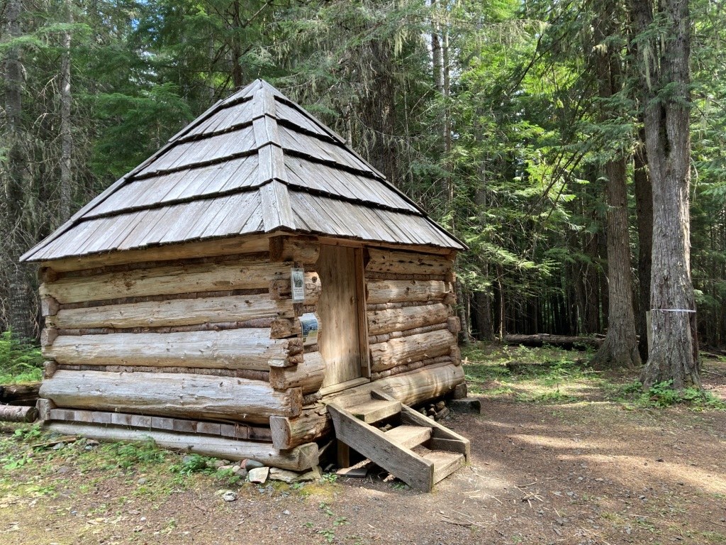
The Gypsy Copper Mining Camp history dates back to 1895 when several men from Colville, Washington made lode claims on nearby areas. The site's original powder house dates to 1895, with the cabin, a bunkhouse, and blacksmith shop following in 1901. The blacksmith shop and bunkhouse are now gone, but due to recent Passports in Time projects on the Colville National Forest, the powder house and cabin are undergoing restoration work.

At the time the mining camp was established, no roads existed in the area. According to signage at this historic site, the miners would spend each summer from the late 1800s into the early 1900s at the camp. This required swimming their horses across the Pend Oreille River at Ione, then travel on horseback to Sullivan Lake where they would use rafts to move their equipment to the north end of the lake (with the horses required to swim alongside the rafts) before traveling by trail along Sullivan Creek to the site of the camp. When the Metaline Falls flume trail was constructed in 1910 they were able to use that route instead. 

Today's visitors can drive up Sullivan Creek Road to a pull-off near the Gypsy Copper Mining Camp, and then hike a short distance on a gated Forest Service Road to the restored powder house and cabin. The site is open to hike in day-use only.

Toilet Information

  • No toilet at trailhead

More information about toilets

Wheelchair Accessibility

The access to Gypsy Copper Camp is via an old Forest Service Road, so it is wide but has vegetation growing in between the tire tracks. According to signage near the historic site "If you are physically unable to hike to the site (about 1/8 mile), a special vehicle access permit can be obtained at Sullivan Lake Ranger Station." However, the main office at Sullivan Lake Ranger Station is closed and no longer staffed, so visitors are advised to call the Newport Ranger Station for more information if interested in this option.

Hike Description Written by
Holly Weiler, WTA Correspondent

Gypsy Copper Camp

Map & Directions

Trailhead
Co-ordinates: 48.8717, -117.1454 Open in Google Maps

Before You Go

See weather forecast

Parking Pass/Entry Fee

None

WTA Pro Tip: Save a copy of our directions before you leave! App-based driving directions aren't always accurate and data connections may be unreliable as you drive to the trailhead.

Getting There

The turn-off to Gypsy Copper Camp is poorly marked: watch for the gate on the north side of Sullivan Creek Road at approximately 1/2-mile east of FR2212 on FR2220, at the spot where FR2220 crosses Gypsy Creek. Park near the gate and hike about a quarter mile to the historic site. Parking is very limited.

More Hike Details

Trailhead

Eastern Washington > Selkirk Range

Gypsy Copper Camp (#0)

Colville National Forest, Newport/Sullivan Ranger District

Guidebooks & Maps

Colville National Forest

You can improve or add to this guidebook entry

Gypsy Copper Camp

1 Trip Report

Hiked here recently?

Submit a trip report!
 
Trip Reports