Trails for everyone, forever

Home Go Hiking Hiking Guide Larch Mountain (Silver Star)

Larch Mountain (Silver Star)

Southwest Washington > Lewis River Region
45.7214, -122.2693 Map & Directions
Length
5.6 miles, roundtrip
Elevation Gain
1,150 feet
Highest Point
3,496 feet
Calculated Difficulty About Calculated Difficulty
Moderate

Wildfire: Trail closed

A low cloud ceiling and views to the northwest from the vista on the trail to Larch Mountain's summit. Photo by Anna Roth. Full-size image
  • Dogs allowed on leash
  • Summits
  • Fall foliage

Parking Pass/Entry Fee

Discover Pass
Saved to My Backpack

Take a short, rugged trek to a forested summit. Along the way, you'll enjoy beargrass in spring, get some good views of the Silver Star Scenic Area, but the best thing about this hike is the workout. Continue reading

Rating
3.50 out of 5

(2 votes) Log in to rate

Hiking Larch Mountain (Silver Star)

Take a short, rugged trek to a forested summit. Along the way, you'll enjoy beargrass in spring, get some good views of the Silver Star Scenic Area, but the best thing about this hike is the workout.

From the trailhead, set off to the southwest (most hikers here will be northeast-bound, heading to Silver Star via the Grouse Vista Trail). Pass the privy at the trail and head uphill (straight the ridge), climbing up a flank of Larch Mountain. The forest around you is nice enough, and quiet, but the grown-up trees do restrict views. After a mile of climbing, arrive at a small saddle, where there’s evidence of a descending trail to your right having been closed off. Ignore that route and stay straight ahead; in just a few hundred feet, bear right at another fork, heading around the base of a small knoll.

There’s evidence that this reroute is relatively new, and it’s quite an improvement over the straight-up route in terms of trail sustainability. Follow this now-more-gently graded trail as it parallels Grouse Creek. At 1.2 miles, a bridge crosses Grouse Creek.

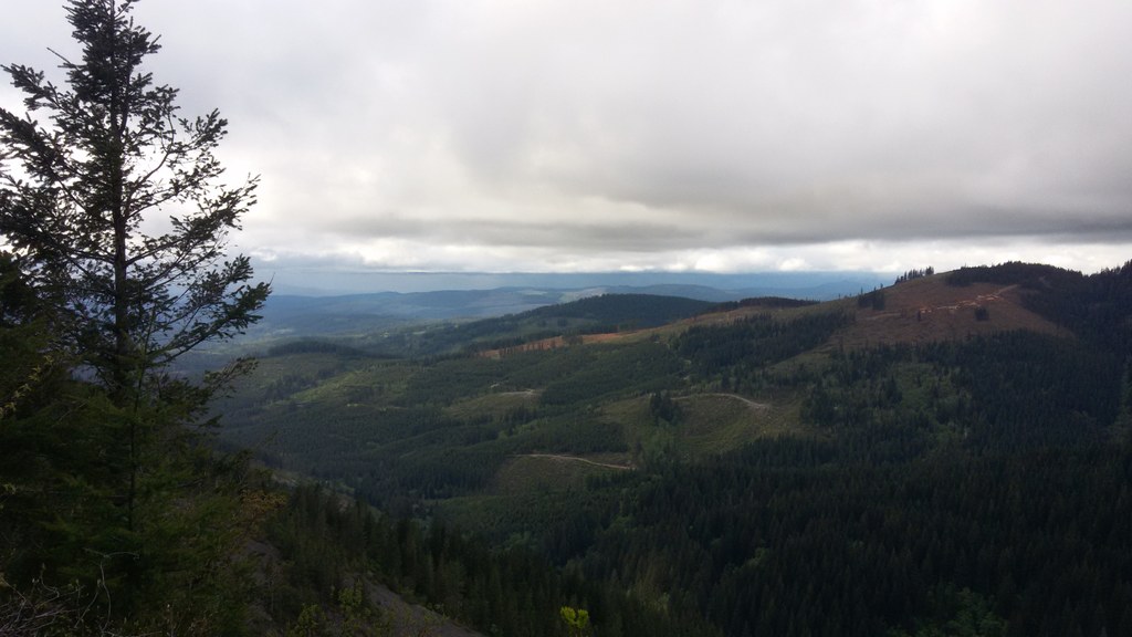
Crossing Ground Creek, continue on through mature forest. Alder begins to overtake as the dominant tree species here, just before you pop out onto another shoulder of Larch Mountain for the best views of the hike.

Here, across the way you can see Silver Star Mountain and sometimes Mount St. Helens. There’s not a great place to sit and enjoy a snack though, so continue to the summit, following the trail for 0.7 miles to a junction.  Bear left at this junction and continue another half-mile to arrive at the summit of Larch Mountain.

It may be a little dismaying to be greeted at the summit by a road and several communication towers, but the road is gated at its base, so you're unlikely to have company in cars. Ignore the towers too, and enjoy views south to the urban centers of Portland and Vancover by walking west a little ways.

Hike Description Written by
Anna Roth, WTA Staff

Larch Mountain (Silver Star)

Map & Directions

Trailhead
Co-ordinates: 45.7214, -122.2693 Open in Google Maps

Before You Go

Wildfire: Trail closed

See weather forecast

Parking Pass/Entry Fee

Discover Pass

WTA Pro Tip: Save a copy of our directions before you leave! App-based driving directions aren't always accurate and data connections may be unreliable as you drive to the trailhead.

Getting There

Heading east on Highway 14, turn left onto the Washougal River Road. (If you're coming from the east, turn right onto the Washougal River Road.)

Drive along this scenic route for nearly seven miles, then turn left and head uphill on NE Hughes Road. Stay on Hughes for 3.2 miles, curving through rural neighborhoods, then make a left onto Skamania Mines Road at the county line.

The paved part of your journey ends at 1.3 miles. This part of the drive can be long, depending on the condition of the road. It’s 1.4 miles on a sometimes-steep graveled road before you bear left at a Y junction. Make another left almost immediately onto DNR Road 1200. Drive for 5.7 miles on this rough road to the trailhead. There is an outhouse here, and parking for probably 20 cars.

More Hike Details

Trailhead

Southwest Washington > Lewis River Region

Washington State Department of Natural Resources

Guidebooks & Maps

USGS Larch Mountain

trail map from Washington DNR website http://file.dnr.wa.gov/publications/amp_rec_yacolt_burn_non_motorized_trails.pdf

You can improve or add to this guidebook entry!

Larch Mountain (Silver Star)

12 Trip Reports

Hiked here recently?

Submit a trip report!
 
Trip Reports