Trails for everyone, forever

Home Go Hiking Hiking Guide Lemah Meadow

Lemah Meadow

Snoqualmie Region > Salmon La Sac/Teanaway
47.4623, -121.2810 Map & Directions
Length
1.0 miles, one-way
Elevation Gain
200 feet
Highest Point
3,250 feet
Calculated Difficulty About Calculated Difficulty
Easy
  • Wildflowers/Meadows
  • Mountain views
  • Dogs allowed on leash
  • Rivers
Saved to My Backpack

Lemah Meadow is a marshy clearing set at the foot of Lemah Mountain. Although the meadow lies along the Pacific Crest Trail, it is most easily reached by the Pete Lake Trail. A couple of scenic campsites make this a fun alternative to staying at the busy shores of Pete Lake. Continue reading

Rating
3.00 out of 5

(4 votes) Log in to rate

Hiking Lemah Meadow

Lemah Meadow is a marshy clearing set at the foot of Lemah Mountain. Although the meadow lies along the Pacific Crest Trail, it is more easily reached by the Pete Lake Trail. A couple of scenic campsites make this a fun alternative to staying at the busy shores of Pete Lake.

While the mileage for this trail is listed as one mile, it only starts once you reach Pete Lake, so hikers heading to Lemah Meadow have a 13.6-mile round trip in store.

From the end of the Pete Lake Trail, head right and away from Lemah Creek. The trail begins to climb the foot of the mountain as the forest opens up into a mix of silver firs and mountain hemlocks that frame the nearby snowy peaks.

A half-mile from the junction, the trail eases into a gentle grade among shaggy, moss-covered limbs. A glimpse of openness on the right hints that the hiker is near the meadow. At 0.9 mile is a small camp site and the junction of the Pacific Crest Trail. Stay right to get to the meadow.

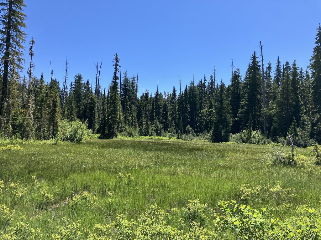
One mile from Pete Lake, Lemah Meadow appears on the right, just beyond a large camp site. Another camp site sits on the left side of the PCT just a short distance farther. Both sites have great views and make a dramatic setting for twilight camp fire stories told from PCT through-hikers and weekenders alike.

WTA worked here in 2022, 2020, 2019, 2018, 2017, 2012 and 2010!

Hike Description Written by
Wes Partch, WTA Correspondent

Lemah Meadow

Map & Directions

Trailhead
Co-ordinates: 47.4623, -121.2810 Open in Google Maps

Before You Go

See weather forecast

WTA Pro Tip: Save a copy of our directions before you leave! App-based driving directions aren't always accurate and data connections may be unreliable as you drive to the trailhead.

Getting There

Lemah Meadow is accessed via the Pete Lake trailheadFrom Seattle, drive east on I-90 and take exit 80 (Roslyn/Salmon la Sac). Turn left (north) on WA-903/Salmon la Sac Road and continue 16.8 miles through Roslyn and past Cle Elum Lake. Turn left (west) on FR-46 (signed for FR 4600) and follow 4.7 miles. Turn right on FR-4616 and continue 1 mile to the trailhead.

More Hike Details

Trailhead

Snoqualmie Region > Salmon La Sac/Teanaway

Lemah Meadow (#1323.2)

Okanogan-Wenatchee National Forest, Cle Elum Ranger District

You can improve or add to this guidebook entry!

Lemah Meadow

25 Trip Reports

Hiked here recently?

Submit a trip report!
 
Trip Reports