

McGregor Mountain is a hiker’s Faustian bargain. It offers you riches of alpine scenery and grand views from the highest point in the Stehekin Valley, but at the cost of your soles. The trail covers almost eight miles on its way to the summit and chews up a massive volume of elevation: more than 6,500 feet. If that sounds daunting, it is; but the toll is exacted more on the way down than on the way up. The trail’s many switchbacks (numbering near 100) make the ascent easier than you’d think (your confidence will soar!), but nothing can blunt the full effect of walking downhill for so long.
There are two starting points to the trail. The standard (and more accessible) trailhead leaves from behind the small outpost at High Bridge. An alternate point of departure is to connect to the Old Wagon Trail/PCT from the former site of the Dolly Varden campground, just before the end of the Stehekin Valley Road. The latter option cuts off a third of a mile and a couple hundred feet of elevation, but is not served by the National Park shuttle bus that stops at High Bridge.
If starting at High Bridge, follow the trail to Howard Lake. Continue past the lake to a trail junction marked by a sign for the McGregor Mountain trail, just before the PCT starts heading back downhill. Here, head right.
If coming from the upper trailhead, head a short distance to a junction with the PCT and turn right. Follow the PCT until it reaches the trail junction and sign for the McGregor Mountain Trail. Head left.
The trail winds its way around and behind Howard Lake and then starts to climb. One particularly long switchback takes you on a hot and dusty traverse above the lake before heading back into the trees on a southwestern shoulder, sometimes verging on Howard Creek to the southeast and an unnamed drainage to the north. The trail remains on the open shoulder for several miles, steadily gaining in elevation. At the top of this section, the trail heads off towards the southeast, straight for the Howard Creek drainage.
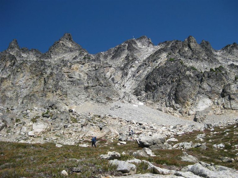
After a little under a mile, undergrowth gives way to a stunted subalpine forest of firs and pines. This is where McGregor begins to reward. As you get clearer and clearer views of the glaciated slopes of Glacier and Dome Peaks, you wander through an increasingly dry landscape forested by diminutive fir trees. The dense undergrowth that once surrounded Howard Creek gives way to a channel carved through talus over which the creek tumbles in a crystalline cascade. As the trail crosses one braid of the creek, larches begin to dot the hillside until you reach the lower of two glacial cirques. The lower cirque is rocky and leads to a terminal moraine of sandy soil. The summit looms overhead.
Just above the terminal moraine, the trail heads up the lefthand side of the cirque and reaches Heaton Camp, a collection of campsites tucked among larches. If you want to break the trek into two days, this is where you’ll overnight. (Which would you rather – power through in a single day or haul 40 pounds of gear a vertical mile in order to get some sleep along the way?) If you do decide to spend an extra night, you’ll do so in one of the finest campgrounds you can find, a lofty perch some 6,700 feet in elevation. If you plan on overnighting, be sure to register at the Golden West Visitor Center before you head out.
The trail continues with its interminable switchbacks above Heaton Camp. The terrain remains dusty and dry, save for the places where a larch or a cluster of wildflowers has established a beachhead.
In roughly a third of a mile, the established trail comes to an end on a rocky outcropping. Beyond it, a talus slope leads to the base of the summit. For most, this is the end of the hike. Time to collect on the deal you struck and take in awesome views of as many peaks as you can count.
A scramble route continues on. Though not particularly technical, it is steep with loose footing and significant exposure in places – best reserved for people with some familiarity with rock climbing or scrambling. Marked by (sometimes faint) red arrows painted on the rock, the route heads to the site of the former fire lookout that stood on the summit until the 1950’s. The way loops first to the right, then back to the left before climbing behind a lower summit to the back of the mountain, crossing a snowfield above the Sandalee Glacier and then heading up a fairly level trail to a radio tower and the true summit, where old rusty nails and broken glass are all that remain of the old lookout. From here, the entire Stehekin Valley is visible, along with perhaps half of Lake Chelan’s 55 miles. Glancing east and north gives you views of the giants of the North Cascades: Silver Star, Black Peak, Corteo, Frisco, Goode. To the west, you seem to gaze level at the mountains surrounding Park Creek Pass and Cascade Pass.
McGregor has held up its end up the bargain, and now it’s time to pay your due. You know exactly what you owe: from the summit, you can see all the way down to the lake and the valley where you must now descend.
 Trailhead


