
Navaho Pass is an excellent introduction to the Teanaway area. Rife with wildflowers, fascinating geology, and just enough elevation gain to keep it interesting, this hike has just about everything that the Teanaway is known for.
From the Stafford Creek Trailhead, the trail starts out in dry forest. The light brown soil and small plants speak to the relative aridity of this area. But that doesn’t mean there isn’t life. Flora abounds here, in an almost unbelievable variety of wildflowers. Scarlet gilia, pearly everlasting, lupine, penstemon of various types, cow parsley, tiger lilies, desert parsley, Indian paintbrush, anemone, Jeffrey's shooting stars, glacier lilies, yarrow, and a host of other wildflowers keep hikers company as they walk along this trail.
The babbling of Stafford Creek provides the soundtrack, at least for the beginning of this hike. After about half a mile of creekside strolling, though, the trail zig zags away, up a steep switchback; a reroute after an avalanche took out a section of trail. Proceed along this section of trail, which lunges upward quite aggressively through two switchbacks before leveling out and then losing elevation to rejoin the creek about a mile in.
From here the grade becomes more moderate, as you gradually climb through meadows, past views of the creek, and beautiful fields of flowers. About three and a half miles in, a ‘T’ junction appears where the trail crosses Stafford Creek to the left and the right-hand trail turns away from the creek. Refill your water bottle here, and consider reapplying sunscreen. You’ve been hiking along a very exposed trail and there’s more of the same ahead of you.
Continue on the right-hand trail, (the one that heads away from the creek) and begin switchbacking uphill. Here the trail is redolent with that signature Teanaway smell: ponderosa pine, yarrow, and sun-warmed earth. Breathe it in deeply–-it’s one of the best parts about this hike.
Five miles in you will reach a large meadow, where there may be tents dotting the ground. Due to the nearby stream, this is a popular camping area, and people make base camp here for long weekends in the Teanaway, including cross-country hiking, ridgeline wandering, and peak-bagging. But this lush meadow doesn’t mark the end of your hike. You have just a bit further on before reaching the pass.
Wind around the right-hand edge of the camp area and head up, crossing the stream and entering a moonscape of dark gray granite mixed in with green serpentine, the signature rock of this area. To the west, Earl Peak looms ahead of you, and a red butte flanks it to the south–-iron in the dirt here makes for colorful, highly photogenic mountains.
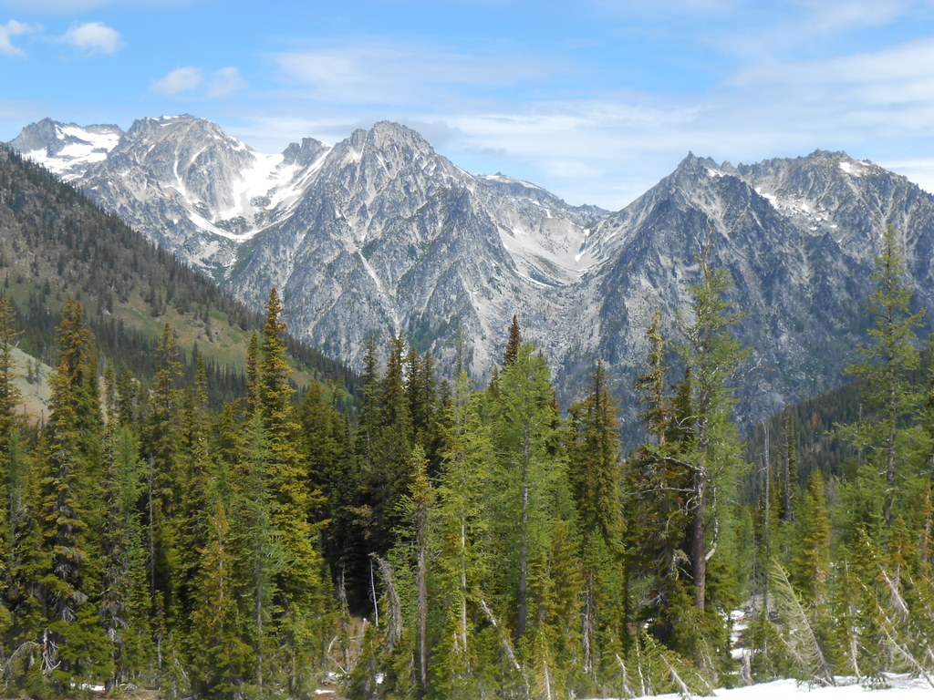
Continue through the rocky fields for less than a mile and follow the trail across a small alpine glade to your destination. Your last steps into the pass reveal an exclamation-inducing sight: Mount Stuart juts into the sky directly in front of you, along with the rest of the Stuart Range. Take in this view or peer down the Ingalls Creek Valley to the east.
WTA Pro Tip: A trail to your right promises better vantage points of this area, but take note; this is the way to Navaho Peak, and once you’ve started for the peak, it will be hard to stop short of it. It’s a steep mile to the summit, but if you feel up to it, the views are even better from there.
Navaho Pass

-
 Length
- 11.0 miles, roundtrip
-
 Elevation Gain
- 3,000 feet
-
 Highest Point
- 6,000 feet
This trail is closed until further notice due to damage from the Labor Mountain Fire.
Navaho Pass is an excellent introduction to the Teanaway area. Rife with wildflowers, fascinating geology, and just enough elevation gain to keep it interesting, this hike has just about everything that the Teanaway is known for.
Continue reading
Hiking Navaho Pass

WTA worked here in 2022, 2019, 2018 and 2017!
Map & Directions
 Trailhead
Before You Go
This trail is closed until further notice due to damage from the Labor Mountain Fire.
Parking Pass/Entry Fee
Northwest Forest PassWTA Pro Tip: Save a copy of our directions before you leave! App-based driving directions aren't always accurate and data connections may be unreliable as you drive to the trailhead.
Getting There
From Seattle, head east on I-90 to exit 85 for East Cle Elum. Cross the freeway on the overpass and turn right onto Hwy 970. Cross the Teanaway River bridge, and in seven miles turn left onto Teanaway Road. Proceed on Teanaway Road for approximately 7 miles, bearing right where it becomes the North Fork Teanaway Road. Follow the North Fork Teanaway Road for approximately 6 miles to the end of the pavement at 29 Pines Campground. Take a slight right onto gravel Forest Road 9737. Follow Forest Road 9737 for a little over a mile. At the first junction after crossing the bridge over Stafford Creek, turn right onto FR-9703, which is signed for Stafford Creek and drive 2.5 miles to the Stafford Creek trailhead.
There is parking here for about 20 cars in the lot, and parking is allowed on the road, but please keep in mind that other cars have to pass, so when parking on the road, leave enough room for traffic to get by. A toilet is available at the trailhead, as are daily Northwest Forest Passes.


