Trails for everyone, forever

Home Go Hiking Hiking Guide Palouse to Cascades Trail - Lake Keechelus

Alert: Major flooding has prompted evacuations and is impacting communities and public lands across Western Washington. Landslide risk and related hazards are very high and have closed trails and roads, including major highways and forest roads.

Check forecasts, consider delaying your hiking or camping plans, and stay safe out there. 


Palouse to Cascades Trail - Lake Keechelus

Snoqualmie Region > Snoqualmie Pass
47.3915, -121.3923 Map & Directions
Length
4.0 miles, roundtrip
Elevation Gain
200 feet
Highest Point
2,500 feet
Calculated Difficulty About Calculated Difficulty
Easy/Moderate

12.9.25 The trail from Hyak to Easton is closed due to washouts until state parks can repair the trail and safely reopen.

Photo by mountainmama. Full-size image
  • Good for kids
  • Lakes
  • Mountain views
  • Summits

Parking Pass/Entry Fee

Discover Pass, Sno-Parks Permit
Saved to My Backpack

For a nice location in the Central Cascades, try this rail trail along the western shore of Lake Keechelus. This is a treat for new snowshoers, especially if it has been recently groomed. Because of its easy accessibility, it can often get crowded on nicer days. Continue reading

Rating
3.67 out of 5

(6 votes) Log in to rate

Hiking Palouse to Cascades Trail - Lake Keechelus

For a nice location in the Central Cascades, try the Palouse to Cascades Trail along the western shore of Lake Keechelus. It can be hiked in any season but is a treat for new snowshoers during the winter, especially if it has been recently groomed. Because of its easy accessibility, it can often get crowded on nicer days.

From the Sno-Park, head south on the trail towards the lake (you will need a Sno-Park permit to park here in the winter). The trail is the former route of the Milwaukee Railroad, so it’s generally level and smooth. Take care to stick to the outer edges of the trail to avoid treading on the groomed ski tracks.

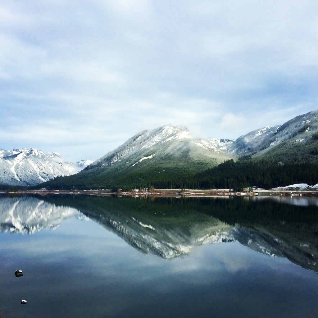
Views along the way are forest on the uphill side and open on the lakeshore side, with a great outlook over the frozen lake and up to Rampart and Keechelus Ridges. At 2 miles you’ll come to the base of a large avalanche chute. This makes a good turnaround point.

Hike Description Written by
Joan Burton, WTA Community

Palouse to Cascades Trail - Lake Keechelus

Map & Directions

Trailhead
Co-ordinates: 47.3915, -121.3923 Open in Google Maps

Before You Go

12.9.25 The trail from Hyak to Easton is closed due to washouts until state parks can repair the trail and safely reopen.

See weather forecast

Parking Pass/Entry Fee

Discover Pass, Sno-Parks Permit

WTA Pro Tip: Save a copy of our directions before you leave! App-based driving directions aren't always accurate and data connections may be unreliable as you drive to the trailhead.

Getting There

From Seattle, drive east on Interstate 90 to exit 54 for Hyak. At the end of the exit ramp, turn right onto WA-906 and then an almost immediate left to stay on WA-906. Continue about 0.4 miles and turn right. The Hyak Sno-Park will be on your right.

More Hike Details

Trailhead

Snoqualmie Region > Snoqualmie Pass

Okanogan-Wenatchee National Forest, Cle Elum Ranger District

Guidebooks & Maps

Snowshoe Routes: Washington (Nelson - Mountaineers Books)

https://www.parks.wa.gov/DocumentCenter/View/11535/Palouse-to-Cascades-Trail---Kittitas-County-West-PDF (PDF)

Buy the Green Trails Snoqualmie Pass No. 207 map

You can improve or add to this guidebook entry!

Palouse to Cascades Trail - Lake Keechelus

71 Trip Reports

Hiked here recently?

Submit a trip report!
 
Loading trip reports...
Trip Reports