

With Mount Stuart peeking over the ridge, take a walk, or ride, through agricultural Kittitas County with its irrigated farming & ranching. Two railroad tunnels and an abandoned farm display some history of the region.
The Thorp Trailhead is at the former site of the Chicago, Milwaukee, St. Paul, & Pacific depot. From the trailhead there are two options, east or west.
To the east is 6.9 miles of open farmland. After an initial 0.1 mile, there is an arrow-straight 1.3 mile section to the crossing of the Ellensburg Power Canal, which fed water to the power plant at Ellensburg from 1904 to 1951. Enjoy the shade of a 1.4 mile section of trees that surrounds the bridge crossing of the Yakima River. The last 4.1 miles, which includes a 3.3 mile straight, passes farms and crosses many county roads before ending at Waters Street, a few blocks northwest of Central Washington University. The trail restarts on the southeast side of the university at the Ellensburg Trailhead. Yes, the university is right on the old railway right-of-way!
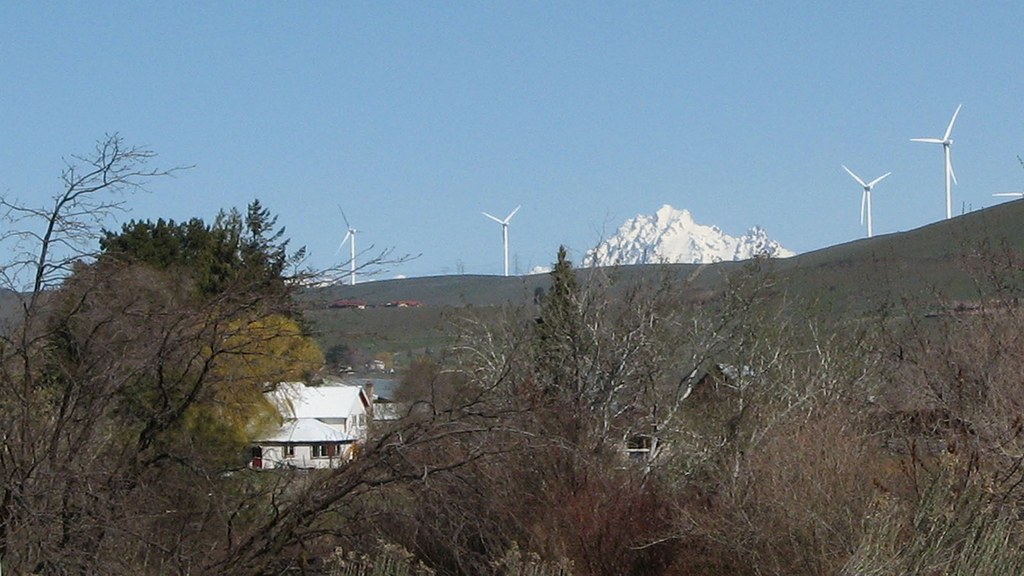
To the west of the Thorp Trailhead is 2.8 miles of farm and ranchland, with the nearby West Side Canal for irrigation. Across the river, the wind turbines of the Kittitas Valley Wind Farm turn in the breeze and Mount Stuart peeks over the ridge.
From the Taneum Creek bridge, the Yakima River comes into view, and the takeout for the West Side Canal. Since the Iron Horse State Park is limited to the original railway right-of-way, access to the Yakima River is mostly abuts private property.
In the next 1.7 miles to Tunnel 46, the trail descends slightly off the bench and the hillside becomes a more natural shrub-steppe ecosystem, with a few cliffs. Spring flowers dot the hillside in a few places and the Yakima River flows past about 30ft below the trail. Across the river is WA-10, the pre-Interstate 90 route through the valley, and a set of active railroad tracks. So, the tranquil sound of the river is sometimes overwhelmed with the sound of automobile or rail traffic.
The entrance to Tunnel 46 shows the effect weathering on the concrete. Even the interior was prone to this effect in recent years as chunks of concrete would fall off the ceiling. Both Tunnel 46 and Tunnel 47 have been refinished inside to prevent concrete from falling on travelers.
Tunnel 46 is short enough, 0.1 mile, to make it through without a light, although there may be a few large rocks in the tread. The 0.3 mile Tunnel 47 has a curve on each end making it darker in the middle. A light is useful when travelling through this tunnel, as there are lots of 3 to 5-inch rocks on the tread.
In the 0.6 mile between the tunnels, abandoned wooden farm buildings (private) show the effects of the years, except for the concrete silo, which still stands. There is a picnic area just before Tunnel 47.
From the exit of Tunnel 47, it is 5.1 miles to the Ponderosa picnic and camping area. The trail stays near the river as it winds up the valley. This area has a more natural feel, including a few pockets of burn from the Elk Heights Fire in 2004.
Out of sight on the ridge above the trail is the Main Canal (irrigation) which starts at Lake Easton. Between Tunnel 47 and the Ponderosa Campground two causeways are used to return water from the canal to the Yakima River. At high flow rates these make impressive manmade waterfalls.
The Ponderosa Picnic Area and Campground has one picnic table for day use, three campsites (10x10 sand pits) each with a picnic table, a payment box for camping fees, and a vault toilet. The river is reachable down a short steep hill. At low river flow rates there is a rocky “beach” and at high flow rates, the river is flowing through the brush on the steep hillside.
Note: For cyclists, this may seem an easy trip with only 160 feet of elevation gain over 11 miles. Remember, this area hosts a wind farm for a reason. Afternoon winds are regularly 15 to 25 mph from the west and northwest. Ideally, travel westward in the morning before the winds pick up and have a wind assisted return in the afternoon.
 Trailhead


