

Poe Mountain is one of a half dozen former lookout sites in the region east and north of Stevens Pass. There are two routes to Poe Mountain, this one is the steeper one up from the Little Wenatchee Campground. The alternative is via Irving Pass, a ridge running trail that is more primitive with a couple of spots of scrambling. The Little Wenatchee Campground route is a well maintained set of switchbacks that climb an additional 1200 feet for a total of 3000 feet due to starting on the valley floor. There are no reliable water sources on either trail, so carry plenty of water for yourself and four legged hiking companions.
Three thousand feet in three miles make the Little Wenatchee a substantial albeit relatively short hike for exercise provided. The trail was the primary supply route to the old Poe Mountain lookout, and like many lookout access trails wastes no time in getting to the top. But it is well built, switchbacking up the hill. The first two-thirds of the hike are in light tree cover, so the views come as a surprise when you get to them.
The upper section of the trail is on an open south facing slope, so it can be warm in midsummer. Late summer and early fall this section has many huckleberry and mountain blueberry bushes. Be cautious stepping off the trail in pursuit of berries; the slope is steep and the footing is challenging.
The trail begins behind the large trailhead sign in the parking lot. Walk northwest up the Wenatchee River Valley 200 yards, looking for a trail junction. The Poe Mountain trail goes off to the right. If you come upon a bridge across the Little Wenatchee River, you missed the turn off.
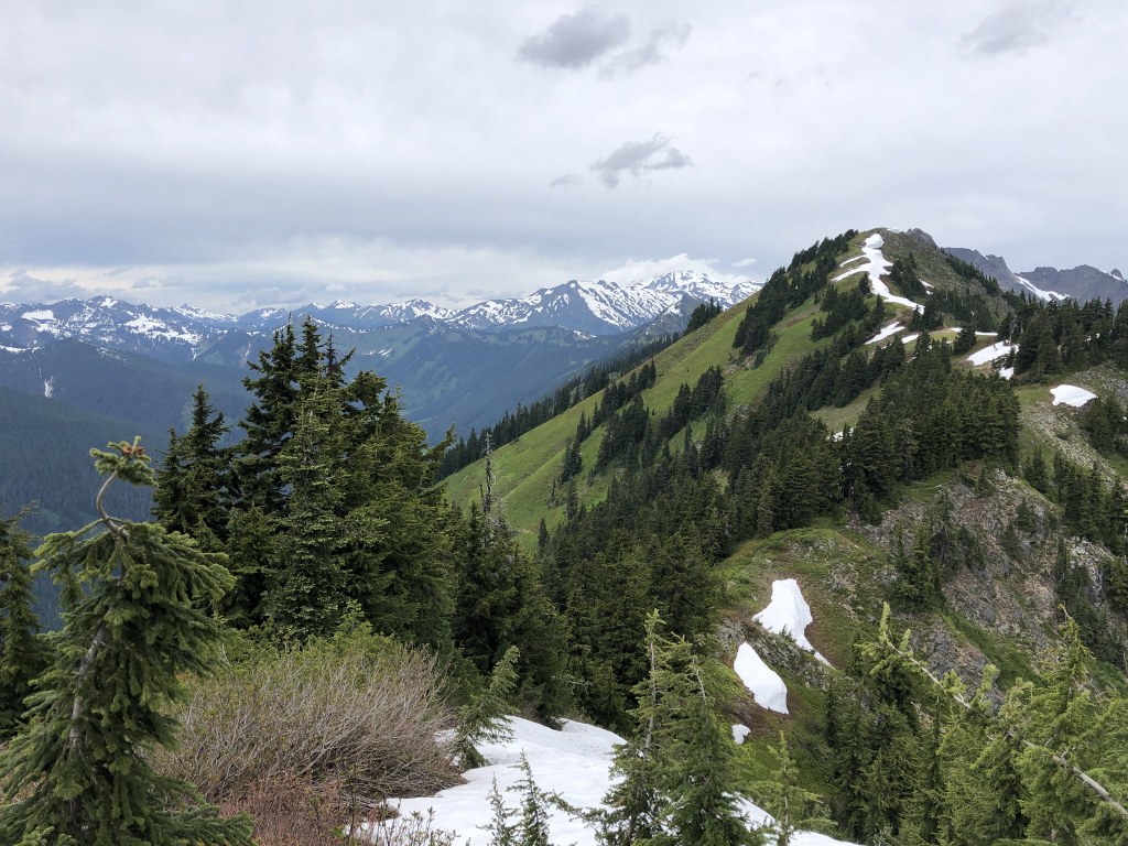
The trail quickly leaves the valley floor and begins switchbacking up the ridge. Once in the open, the views on this route are all to the south, across the Little Wenatchee Valley you can see Labyrinth Peak above Minotaur Lake and other peaks along the Pacific Crest trail south of Stevens Pass. From the summit there are views of Glacier Peak, up the Little Wenatchee River to Meander Meadow and Kodak Peak, and on a clear day Rainier can be seen on the southwest horizon.
There is a single signed junction on the trail, just below the summit where a right branch of the trail leads to Irving Pass and the left junction takes you that last little bit to the summit.
Adventurous cross country hikers can continue along the ridge to Longfellow Mountain, Bryant Peak or Kodak Peak, returning down the Meander Meadow trail. This is a big endeavor. Look at a map before setting out.
Hiking Correspondent Editorial Opinion: When asked which route to take, my first answer is to hike to Poe via Irving Pass, you spend a lot more time with views, when you are not watching your footing. An alternative with a bigger group is to hike Irving Pass, split the group at the top and send hikers that want a longer return down Poe Mountain trail (this description) to Little Wenatchee Campground and have the Irving Pass group pick them up on the drive out. This does add an extra 30 minutes of driving but shows you the Cady Ridge and Meander Meadow Trail heads for another day.
 Trailhead


