Trails for everyone, forever

Home Go Hiking Hiking Guide Priest Rapids Shoreline Trail

Priest Rapids Shoreline Trail

Central Washington > Tri-Cities
46.6838, -119.9319 Map & Directions
Length
6.5 miles, roundtrip
Elevation Gain
45 feet
Highest Point
538 feet
Calculated Difficulty About Calculated Difficulty
Easy/Moderate
The view from the Priest Rapids Shoreline Trail combines arid landscape and cool, blue water. Photo by Mary Hartman. Full-size image
  • Dogs allowed on leash
  • Established campsites
  • Good for kids
  • Lakes
  • Rivers
  • Wildflowers/Meadows

Parking Pass/Entry Fee

None
Saved to My Backpack

Enjoy easy walking, wide-open views and plenty of sunshine along the Columbia River shore near Priest Rapids Dam. Continue reading

Rating
3.00 out of 5

Hiking Priest Rapids Shoreline Trail

The Grant County Public Utility District operates the Priest Rapids and Wanapum hydroelectric dams on the Columbia River in Central Washington. Federal license requirements specify that the PUD must balance the diverse needs of power, fish, wildlife, tribal groups, flood control, irrigation and recreation. The Priest Rapids Recreation Area and the shoreline trail provide opportunities for recreation, hiking and camping.

The wheelchair friendly 3.2-mile Priest Rapids Trail runs parallel to the Columbia River near the community of Desert Aire. Priest Rapids Recreation Area is an irrigated park with a 14-site campground, a small swimming beach and boat launch at the approximate center of the trail. North of the park, the trail is paved. South of the park, the trail is a wide gravel road that is closed to motor vehicles. Picnic tables and benches are interspersed along the length of the trail, and there are locations where you can access the river to cool your feet. Parking, picnic tables and vault toilets are available at the park and at the north and south trailheads, but there is no potable water, so be sure to bring your own.

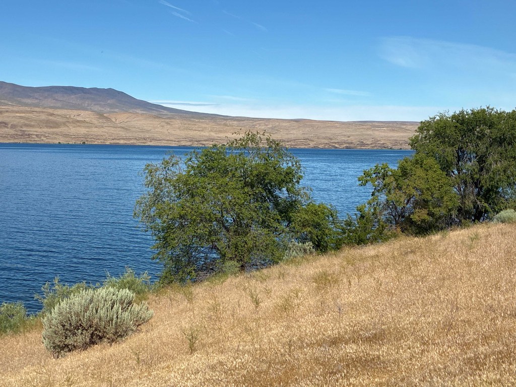
The trail passes through long expanses of beautiful shrub-steppe habitat. Outside of the recreation area park, there is very little shade except in places where cottonwoods and willows grow beside the river. 

There are other good places in the area to visit. The north trailhead is near the Washington Fish and Wildlife’s Priest Rapids Wildlife Area Unit, with a boat launch and wildlife viewing blinds (Discover Pass required). A short distance from the south trailhead is the Wanapum Heritage Center, with a wealth of thought-provoking exhibits about the Wanapum People. There is no charge for admission, but check their website for operating hours.

Toilet Information

  • Toilet at trailhead
  • Accessible toilet

More information about toilets

Wheelchair Accessibility

The entire trail is firm and wide, with little or no slope. The north part of the trail is asphalt and the south part is compacted gravel.

Hike Description Written by
Mary Hartman, WTA Correspondent

Priest Rapids Shoreline Trail

Map & Directions

Trailhead
Co-ordinates: 46.6838, -119.9319 Open in Google Maps

Before You Go

See weather forecast

Parking Pass/Entry Fee

None

WTA Pro Tip: Save a copy of our directions before you leave! App-based driving directions aren't always accurate and data connections may be unreliable as you drive to the trailhead.

Getting There

From Vantage, cross the Columbia River on I-90 and take exit 137. Drive south on WA-26 for 1 mile, then turn right on WA-243. Drive about 17 miles and turn right onto the main road to the Desert Aire community (Desert Aire Drive). Drive about 1.3 miles and turn left into the recreation area.

From Tri-Cities, drive west on WA-240. At about 30 miles, continue straight on WA-24. After crossing the Vernita Bridge over the Columbia River, turn left on WA-243. Drive 9.9 miles and turn left into Desert Aire, then follow the directions above.

More Hike Details

Trailhead

Central Washington > Tri-Cities

Grant County Public Utility District

Guidebooks & Maps

https://www.desertairetoday.com/area/attractions

https://509river.org/campsites/priest-rapids-recreation-area/

USGS Priest Rapids

You can improve or add to this guidebook entry!

Priest Rapids Shoreline Trail

1 Trip Report

Hiked here recently?

Submit a trip report!
 
Trip Reports