Trails for everyone, forever

Home Go Hiking Hiking Guide Redmond Watershed Preserve

Alert: On Oct. 1 the federal government began a partial shutdown that will impact National Parks, National Wildlife Refuges and U.S. Forest Service lands in Washington. Here's the latest information we have for hikers and campers


Redmond Watershed Preserve

Puget Sound and Islands > Seattle-Tacoma Area
47.6968, -122.0515 Map & Directions
Length
4.5 miles, roundtrip
Elevation Gain
400 feet
Highest Point
580 feet
Calculated Difficulty About Calculated Difficulty
Easy/Moderate
A hiker on a trail in Redmond Watershed Preserve. Photo by Yas Obara. Full-size image
  • Dogs not allowed
  • Fall foliage
  • Good for kids
  • Rivers
  • Wildlife

Parking Pass/Entry Fee

None
Saved to My Backpack

Explore 800 acres of wooded area right in Redmond’s backyard. Continue reading

Rating
4.21 out of 5

(14 votes) Log in to rate

Hiking Redmond Watershed Preserve

In 1926, the city of Redmond purchased a piece of land from Weyerhaeuser, intending to use Seidel Creek as a water supply. More acreage was later purchased to bring the watershed to 800 acres, however water quality issues led to the use of other water sources. Now this beautiful wooded area is managed primarily as a nature preserve, with a focus on protecting its wide variety of habitats, including ponds and other wetlands. In the interest of protecting the quality of these habitats, the preserve has enacted the following rules:
no pets, no alcohol, no fires or smoking, and no firearms. Please abide by these rules in order to keep the outdoor experience pleasant for all trail users.


The park's trails are multi-use: popular for hikers, trail runners, mountain bikers, and horseback riders. Be prepared to share the trail and look out for horse droppings. An underground natural gas line and pipeline regional trail above it runs north to south through the middle of the park, and an overhead power line runs east to west. Several regional trails pass through the park.

You can pick up a brochure -- which includes a trail map -- at the signboard near the parking lot. The park has more than seven miles of trails, but take note of which ones are open to which kind of users. The Trillium Trail on the west side of the park is for equestrians and hikers. Siler’s Mill Trail on the east side of the park is gated and for hikers only. Each of the trail intersections is signed and has a map letting you know where you are.

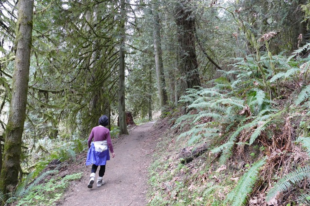
To see as much of the park as possible, make a 4.5-mile long loop starting from the parking lot. Take the Trillium Trail and the Siler’s Mill Trail by connecting them with multi-use trails. The grade is gentle and the trails are mostly in good condition. The loop goes up and down and gains about 400 feet total in elevation. The trails run through second-growth forest of Douglas firs, cedars, cottonwoods and maples. The trees are covered with moss and the ground is covered with sword ferns. Enjoy the chirping of birds, the croaking of frogs, and the smell of fir trees. In springtime, trillium flowers also make an appearance.

Toilet Information

  • Toilet at trailhead
  • Accessible toilet
  • Toilet has running water

More information about toilets

Wheelchair Accessibility

The paved parking lot off 218th Ave NE and Novelty Hill Rd has 3 van-accessible spots located near the bathrooms. 

The bathrooms have power and running water, with a drinking fountain outside. Both men's and women's sides of the bathroom offer push button doors powered openers to enter. Inside there are accessible stalls large enough to turn around a power wheelchair in them. Sinks, hand dryers, and baby change tables are at wheelchair accessible heights, however the soap dispensers are not.

The Treefrog Loop Trail is a 0.7-mile paved trail that is barrier-free for wheelchair users and should be accessible to all. The pavement is in good shape, has a minimal cross slope and a gentle rolling grade. Some of the maps show it as a loop, but it is more of a lolly-pop trail with a short spur to an accessible viewpoint of a pond. The trail is accessed via a crosswalk on the entrance road just to the east of the bathrooms.

The Trillium Trail, Powerline Trail and Pipeline Trail can be accessed from the north end of the parking lot via the Trillium Connector Trail. While not maintained to be wheelchair accessible, there are no hard barriers to prevent more adventurous wheelchair users.

The Trillium Trail and Trillium Connector Trail, are both very rough and rocky with lots of roots. But they are not impassible to those in more off-road oriented chairs, especially with assistance. The trails are plenty wide enough for wheelchairs, and cross-slopes are very manageable. There are sections of grade that are significantly steeper than ADA standards, such that most may prefer having a spotter or assistance behind them. 

The Powerline Trail and Pipeline Trail are much nicer surfaces to roll on, being either small gravel or smooth hardpack. However, they do have numerous water diversion bars across them that may be a barrier to some. But none are higher than a standard curb, and they are spaced far apart so they don’t turn into stairs. Cross-slope is also good, but again grade in sections exceeds ADA guidelines.

The Siler’s Mill Trail, which branches from the Pipeline Trail, has equestrian barriers on it which make it completely inaccessible to wheelchairs.

[Accessibility notes provided by Z. K.]

Hike Description Written by
Yas Obara, WTA Correspondent

Redmond Watershed Preserve

Map & Directions

Trailhead
Co-ordinates: 47.6968, -122.0515 Open in Google Maps

Before You Go

See weather forecast

Parking Pass/Entry Fee

None

WTA Pro Tip: Save a copy of our directions before you leave! App-based driving directions aren't always accurate and data connections may be unreliable as you drive to the trailhead.

Getting There

Driving Directions

From Seattle, drive east on SR 520 until it becomes Avondale Road. Continue on Avondale Road, and after 1 mile go slight right at the fork onto Novelty Hill Road before the traffic light. Go straight for 2.3 miles, and turn left at Redmond Watershed Preserve sign across from 218th Ave NE. The parking lot has room for about 40 cars. There is a modern restroom, picnic tables, and a parking lot for horse trailers.

A secondary trailhead is located on the north side of the preserve. From Seattle, drive east on SR 520 until it becomes Avondale Road. Continue on Avondale Road, and after 3.2 miles turn right on to NE 132nd St. 0.1 miles later, turn right again after Fire Station 33, on to NE 133rd St. Go straight for 1.6 miles, and turn on to 218th Ave. NE. A gravel parking lot will be on the right after about 400 ft. No bathrooms or facilities at this lot. Has room for about 20 cars.

Take Transit

This trailhead is accessible by bus! Plan your visit by bus using TOTAGO, or consult the schedule for King County Metro DART route 224.

Get off at Cedar Park NE and NE Marketplace Dr.

More Hike Details

Trailhead

Puget Sound and Islands > Seattle-Tacoma Area

City of Redmond

Guidebooks & Maps

http://www.redmond.gov/common/pages/UserFile.aspx?fileId=24797

You can improve or add to this guidebook entry!

Redmond Watershed Preserve

224 Trip Reports

Hiked here recently?

Submit a trip report!
 
Trip Reports