Trails for everyone, forever

Home Go Hiking Hiking Guide Return Trail

Return Trail

Southwest Washington > Columbia River Gorge - OR
45.5778, -122.1173 Map & Directions
Length
1.2 miles, roundtrip
Elevation Gain
100 feet
Highest Point
100 feet
Calculated Difficulty About Calculated Difficulty
Easy
A small cave on the Return Trail. Photo by Anna Roth. Full-size image
  • Dogs allowed on leash
  • Good for kids
  • Waterfalls

Parking Pass/Entry Fee

Northwest Forest Pass
Saved to My Backpack

A short trail between Multnomah Falls and Wahkeena Falls that makes a loop trail possible between the two. Continue reading

Rating
0.00 out of 5

(0 votes) Log in to rate

Hiking Return Trail

The Return Trail is a short, half-mile trail between Multnomah Falls and Wahkeena Falls. From the base area of Multnomah Falls, the trail sets off to the west of the main area, past the historic lodge and the restrooms.

Hikers are encouraged to take this trail in order to stay off the historic Columbia River Highway; its so narrow that pedestrians can severely restrict traffic flow on the road.

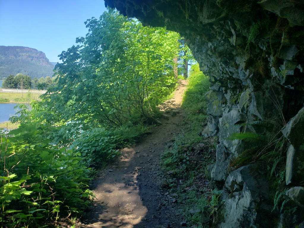
Set off from the base area and climb up a fairly steep but short section of wide, packed-dirt trail. At the crest of the trail, you'll see that the trail goes under a basalt cave and then swoops back uphill.

At the top of that section, there's a surprise waterfall! This medium-large shower is a lovely little bonus after a long looping hike with waterfalls.

Past the falls, the trail is quiet (considering the highway is right there) and straightforward for the rest of the way back to the Wahkeena Falls. You'll have some views of the Benson Lake Recreation Area before arriving back at the Wahkeena Falls picnic area and trailhead.

Toilet Information

  • Toilet at trailhead
  • Accessible toilet
  • Toilet has running water

More information about toilets

Hike Description Written by
Anna Roth, WTA Correspondent

Return Trail

Map & Directions

Trailhead
Co-ordinates: 45.5778, -122.1173 Open in Google Maps

Before You Go

See weather forecast

Parking Pass/Entry Fee

Northwest Forest Pass

WTA Pro Tip: Save a copy of our directions before you leave! App-based driving directions aren't always accurate and data connections may be unreliable as you drive to the trailhead.

Getting There

All vehicles need a timed-access permit if you're planning to visit here between late May and early September.

Coming from Portland, drive east on I-84 to exit 31 for Multnomah Falls. Park and walk underneath the interstate and railroad tracks to the Lodge and Visitor Center. You can also access the falls via exit 28 for Bridal Veil. This is three miles before the Multnomah Falls exit. This is a nice option if you want access to other trailheads, or you don't want to fight for a parking space near the falls.

Coming from the east, Travel west on Interstate 84 to exit 35 for Ainsworth State Park. Drive along the narrow Historic Highway west four miles to the site's parking area.

There is accessible parking available in both the upper and lower parking lots. Paved paths lead to the Visitor Center from both parking lots, but note that there are some slight inclines along the way from the parking lots to the visitor center and around the falls viewing area.

Alternately, you can park at Wahkeena Falls and hike this the other way around.

More Hike Details

Trailhead

Southwest Washington > Columbia River Gorge - OR

Return (#442)

Columbia River Gorge Recreation Area

You can improve or add to this guidebook entry!

Return Trail

1 Trip Report

Hiked here recently?

Submit a trip report!
 
Loading trip reports...
Trip Reports