Trails for everyone, forever

Home Go Hiking Hiking Guide Thompson Lake via Granite Creek Trail
link

Thompson Lake via Granite Creek Trail

Snoqualmie Region > North Bend Area
47.4921, -121.6399 Map & Directions
Length
14.2 miles, roundtrip
Elevation Gain
3,400 feet
Highest Point
4,200 feet
Calculated Difficulty About Calculated Difficulty
Hard
Thompson Lake. Photo by Joel_Grant. Full-size image
  • Mountain views
  • Dogs allowed on leash
  • Lakes
  • Rivers

Parking Pass/Entry Fee

Discover Pass

Hike a well-built trail to a beautiful, quiet, forested lake at the edge of the Alpine Lakes Wilderness. Continue reading

Rating
4.18 out of 5

(11 votes) Log in to rate

Hiking Thompson Lake via Granite Creek Trail

If you're using Trailhead Direct, head down the Middle Fork Road for 0.18 mile to a parking area for the Granite Creek Connector. The trail takes off here, paralleling the road for about a mile before switchbacking away. Traverse the hillside, crossing many creeks as you go. The forest here is deep and lush, and burbling water accompanies you as you trek along. 2.8 miles from the trailhead, arrive at a junction. The trail coming from the left is the Granite Creek Trail, which starts at a trailhead, not (yet) serviced by Trailhead Direct. Turn right at the junction.

Now you’re paralleling Granite Creek. Just a tenth of a mile from the junction, a spur trail to the left offers an overlook of the creek, and another tenth of a mile on, a lovely new bridge is a great place to stop for a break. Here, you’re three miles into your hike.

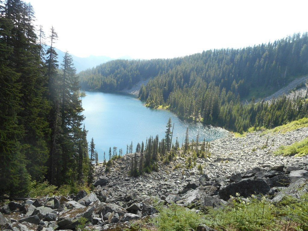
It’s two more miles to your next significant junction. Be aware that this section of trail is prone to flooding and in the shoulder season you may need to ford creek crossings. A little more than a mile from the first junction, look to the right for views of Mailbox Peak. 0.7 mile past those first views, arrive at a second junction. To the right is a trail to Granite Lakes. While it’s a nice day destination, camping is not allowed at Granite Lakes.

If you’re camping, the trail to the left is what you want. It’s 2.1 miles of up-and-down to Thompson Lake, which sits just inside the Alpine Lakes Wilderness in the Mt. Baker-Snoqualmie National Forest. Once you arrive, find a spot and set up camp.

Hike Description Written by
Anna Roth, WTA Staff

Thompson Lake via Granite Creek Trail

Map & Directions

Trailhead
Co-ordinates: 47.4921, -121.6399 Open in Google Maps

Before You Go

See weather forecast

Parking Pass/Entry Fee

Discover Pass

WTA Pro Tip: Save a copy of our directions before you leave! App-based driving directions aren't always accurate and data connections may be unreliable as you drive to the trailhead.

Getting There

Driving Directions

Drive I-90 to exit 34. Turn left onto 468th Ave SE and follow it 0.6 miles to the junction with SE Middle Fork Road. Turn right and follow SE Middle Fork Road 2.1 miles, until reaching a fork and staying right on Lake Dorothy road. Pass the Granite Creek Connector trailhead 0.7 miles later, on your right. 2.2 miles farther, just before the bridge across the Middle Fork Snoqualmie River, reach a driveway to your right, which leads to the Granite Creek trailhead. The trailhead has parking for 37 vehicles (2 disabled spaces). A privy and kiosk with a map are at the parking area. There is overflow parking along FR 56, opposite the trailhead, for 14 vehicles.

More Hike Details

Trailhead

Snoqualmie Region > North Bend Area

Mt. Baker-Snoqualmie National Forest, Snoqualmie Ranger District

You can improve or add to this guidebook entry

Thompson Lake via Granite Creek Trail

141 Trip Reports

Hiked here recently?

Submit a trip report!
 
Trip Reports