

Do you like green? Vivid green leaves, fluffy green mosses, green pine needles, perhaps the deep green of a bottle of Off! Deep Woods with DEET? Then the Walupt Lake Loop (in early summer) is for you! This trail offers a more than 15 mile outing in the country east and south of Walupt Lake, and in early summer, the bushes are bursting with new growth and the bugs are biting. But if you visit in late summer, the greenery has faded back, the berries are out, and you may even enjoy nice views from the 5100-foot high point.
Beginning at the trailhead at Walupt Lake, set off down the Walupt Lake trail, paralleling the lake, which is visible for the next 2 miles through the trees to your right. This trail is quite flat, undulating gently along the hillside and gradually dipping into rocky gullies. Steep trails access the lakeshore periodically if you'd like to visit.
After about 1.8 miles, the trail climbs briefly before dropping down into a river bottom, then turning left before popping out on the banks of Walupt Creek. Cross Walupt Creek, which may run high in the spring, and then look for the rooty trail across the way. This begins climbing almost immediately, at a moderately steep grade.
Switchbacks lead to higher, more airy forest. Here, the understory thins out somewhat, and camps on either side of the trail indicate proximity to the Pacific Crest Trail (PCT). Indeed, just two miles from the creek crossing top out at 5000 feet at a trail junction with the PCT.
Your route is over your right shoulder. The trail to your left leads north on the PCT, and is part of the Nannie Peak Loop. Straight ahead of you here is a path leading to the edge of the Goat Rocks wilderness and the border with the Yakama Reservation. Please refrain from passing into the reservation lands, as they are closed to the public.
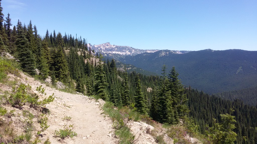
The PCT section of this hike is where the bugs will be bad in the right season. This 5.3 mile long section weaves through marshy bottomland and is overgrown in places, but never too hard to follow. It's also very flat, gaining just a few feet of elevation over 3.5 miles. Those few feet make a difference, though; it puts you into open forest slightly higher than the marshy area you hike through at the beginning of this part.
After about 4 miles of hiking, the trail begins to climb, gradually at first and then more steeply before finally breaking out into an open, rocky area with views of Nannie Peak and the Goat Rocks. Turn around and see Mount Adams peeking out from around the shoulder of a ridge.
The high point of 5712 feet is presented without fanfare -- it's just a little flat section of trail before it starts to descend back into forest. Take a break and explore here, though. Through the trees you can see Mounts Rainier, Adams, and St. Helens, as well as the Goat Rocks.
Once you're done here, begin hiking downhill. It's 1.6 miles back into deeper forest before coming to a junction where the PCT peels off to the left. You will continue straight ahead, now on the narrower, steeper, and more rugged Coleman Weedpatch trail. The unusual name is for the area you just hiked through; the marshy bottomland is known as Coleman Weedpatch.
Descend on the Coleman Weedpatch trail for 1.1 miles to another junction, where the Klickitat Trail 7A peels off to the left. Again, continue on the Coleman Weedpatch trail on a more moderate grade, rounding the backside flank of a mountain visible from Walupt Lake.
Pop out at the trailhead for the Coleman Weedpatch. To your right, a sign indicates the Horse Route, which heads back to the Walupt Horse Camp. Follow this trail, which is about half a mile, to the Horse Camp, then walking through the Horse Camp to site 4, look for another trailhead with a small kiosk.
Walking just a few feet up this trail, another sign proclaims "Walupt Lake 3/4". Actually, it's more like 0.9 miles. Turn left, following the arrow, and hike along. At an intersection where a sign points straight on to "Walupt Trail Parking" turn right, and keep following this trail, which can be faint at times. It climbs high above the road, before dropping suddenly and somewhat steeply down to the very western edge of the lake, near the sign welcoming visitors to Walupt Lake Campground.
WTA Pro Tip: You can also walk the road from the Coleman Weedpatch trailhead. However, it's only 0.2 miles shorter, and has much less shade. Though fairly faint and rugged, the Horse Trail is a better option for most people.
 Trailhead


