
C2C attempt via Coleman glacier. Turned around at 9,890ft below the Roman wall. 6,900ft gain over 13.8mi in 15hrs. Route in great shape, mostly a roped walk-up in crampons condition snow and no open crevasses on route. Our turnaround decision was based on our group's overall risk tolerance of steep snow. In my opinion, the route is in prime shape for summiting.
Approach to the approach
1.2mi (600ft elevation gain) of road walk took about half an hour. Road was mostly dry and the snow patches had boot tracks. We started early at 1:30am to (1) get ahead of the crowd (expected a busy day on the first day / the best forecasted weather day of the Memorial holiday weekend and the 2nd day of trailhead reopen), (2) leave plenty of buffer time since it was the season opening climb for all of us due to quarantine.
Ascent
A small creek crossing at 1.4mi, where a snow bridge collapsed. Just hop on the small rocks and use poles to probe and maintain balance. Fast current in the early AM. First ~2mi had plenty of melted sections with some creek running across and some downed trees to hop over. We all carried 4L+ of water, not expecting running water to refill from. The snow covered sections had were packed down with boot tracks. Snow was firm but not icy, perfect traction for boots. Familiarize yourself with the route as there were quite many snow/trail transitions and the snow covered sections cut the switchbacks by a lot. A rock island led to the Hogsback camp (only saw 1 tent). Passing the camp we arrived at the Coleman glacier at around ~6,000ft, and roped up at a relatively flat spot, as a precaution for the potentially hidden crevasses, and took out ice axes, crampons and helmets. Fresh snow from last 2 days had covered some old boot tracks in the low angled slope. Broke trail again in ankle-deep powder. Before the slope steepened, we found another set of recently made boot tracks. An avalanche debris to the left of us in some distance. Also noticed that every step we kicked moved a ~2in layer of snow. Remember to look around for potential avalanche activities and debris and pay attention to the ever changing snow/weather conditions as you decide where to go and to take breaks. At the 7,000ft high camp we only saw 2 tents and room for a few more. A slog on a gentle slope until the ridge at 9,000ft. For a short section, snow was crunchy and broken in layers like a staircase and made walking more tiring. Icier and steeper snow after where the boot tracks were kicked sideways in or just front point in.
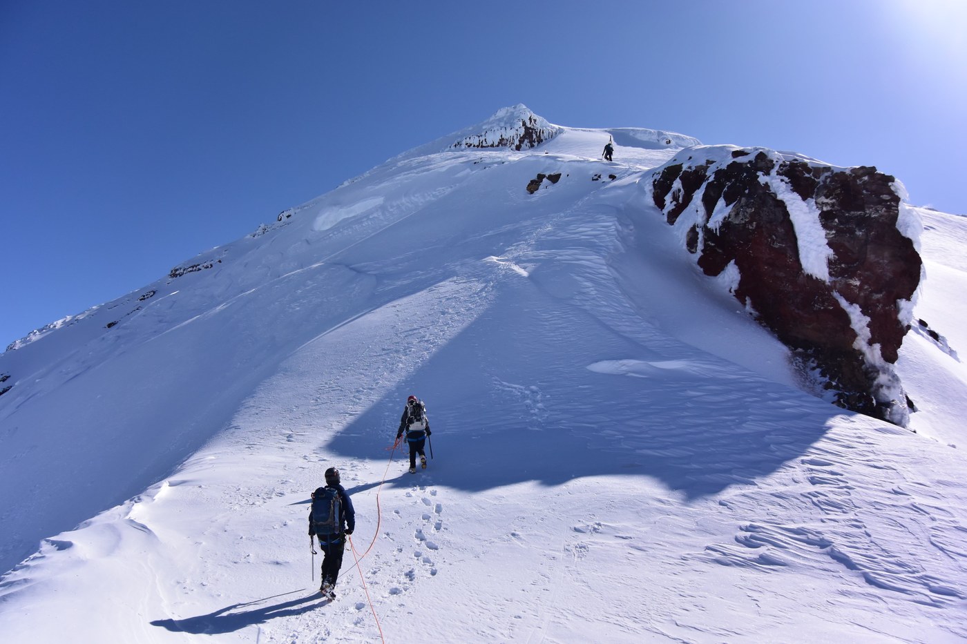
Turned around just below 10k ft below the Roman wall.
Throughout the day, we didn't see any other group rope up below the high camp (7,000ft). Most skiers didn't bother until at least 9,000ft. We could have waited a little longer, but didn't want to wait until absolutely necessary and then there might not be a good spot, better be safe than sorry.
Descent
Plenty of fresh snow to plunge step down. Dozens of groups were heading up at this time, mostly skiers skinning up in parallel to us. Expecting a highway of boot tracks after this holiday weekend. Leaving high camp, we walked into a complete whiteout. A good reminder to track your climb and have historical tracks loaded to your phone / printed out to navigate. From there to the low camp, it was a nightmare of close to 600ft of knee-deep postholing in the mashed potato snow with no visibility in the sun-baked whiteout lol... We unroped at the low camp but still kept crampons and ice axes to be prepared for the possibly firm snow below and that turned out to be a good decision. Uneventful hike-out in the drizzling rain.
Track
Driving
Heliotrope Ridge trailhead (https://goo.gl/maps/ZJYzSyNeD41w9yn98). Last 8mi leading to the trailhead on Glacier Creek Road (FS-39) started getting bumpy and postholey after 2mi in. High clearance recommended, but road was passable with caution. Large part of the road was narrow and windy, stay right and slow down to be prepared to yield to the oncoming cars. Road was clear of snow 1.2mi below the trailhead. The rest of the road was mostly melted out, but the patches of snow here and there On our hike out, more cars (all SUVs) made it closer to the trailhead. Expect snow to melt quickly with the warming temperature in the coming week. Don't forget to leave plenty of room for other cars to pass when you park. No facilities at the trailhead, toilet, picnic table and trash cans were partially covered in snow. Remember to bring blue bags and toilet paper, and pack your trash out.
Good news Train Wreck Bar & Grill (https://goo.gl/maps/6iJPJ6P3V6x8dff77) in Burlington is now open for takeout, and their temporary hours are 9am-8pm Mon-Fri, and 8am-8pm Sat-Sun. Go support one of your favorite after-climb restaurants :)
Stats
0130 Left cars (1.2mi from trailhead)
0200 Trailhead
0430 Hogback camp
0600 High camp at 7,000ft
1030 Turned around at 9,890ft
1430 Hogsback camp
1630 Trailhead
1630 Cars
Gear
Standard glacier and crevasses rescue gear, picket, 10 essentials, lot of sun protection, pole
Car camping: tent, sleeping bag, sleeping pad, blue bags, toilet paper, trash bags, toothbrush and toothpaste
Comments:
- Poles are useful for creek crossing. Can be shared.
- Wish I brought another pair of thinner gloves for the warmer afternoon, when it's used not for warmth, but just to protect my hands when holding ice axe in case of self-arrest.
- Apply sunscreen and chapstick regularly, at least every 2hrs after sun comes out. Too easy to forget a spot or forget how intense sun reflected off snow is
Route
Mountaineers:
https://www.mountaineers.org/activities/routes-places/mount-baker-coleman-glacier
Summit post: https://www.summitpost.org/coleman-deming-glaciers/155420
3700ft Trailhead
5,900ft Hogsback camp (low camp)
7,000ft High camp
10,778ft Summit
Forecast
Mountain forecast: https://www.mountain-forecast.com/peaks/Mount-Baker/forecasts/3285
NOAA: https://forecast.weather.gov/MapClick.php?lat=48.8019170108&lon=-121.895670891#.XsXmI5NKjEY
Some thoughts regarding covid-19
- Fuel up your cars and stock up food/snacks for after the climb before leaving the city - Everett or Burlington at the furthest, to (1) avoid exposing ourselves to the more remote and vulnerable towns, (2) not expect the gas stations and stores to be open as normal anywhere closer to the trailhead.
- Have a buff handy, and be ready to cover yourself if we find ourselves in any crowded places (parking lot, trailhead, summit, camp, etc)
- Solo driving is tiring, especially after the climb and/or in the dark. Remember to take breaks as needed and don’t risk it :)
Comments
ArthurPereira on Mount Baker
Hi, detailed report is good. I am thinking of attempting the summit this weekend or next. Thought I will check with someone who can give me a view. Can I pm you? Contact?
Posted by:
ArthurPereira on May 25, 2020 06:17 PM