
I spent a couple nights up here on a glorious solo getaway from Sunday evening until Tuesday morning. Much of what is in this report may not be relevant within the next week or so as rain and then warm temps forecasted through the rest of this week will mean conditions change quickly, but with little beta out there for the trail, this is going to be a long one, so settle in.
Having put in for my permit during the window back in March, I just had to swing by the WIC and pick them up, no sweat about walk-up availability (although you can check that on the NP website). The road up is overall not too bad, but there are some steep sections that have become quite washboarded. A sedan can make it – there was one in the parking lot when I arrived – but I appreciated my AWD and extra bit of clearance. Coming down through those sections was honestly worse than going up. It is easy to pick up too much speed and hit those sections faster than you'd like. People doing this and then hitting the brakes hard actually contributes to more washboarding, much like the washboards that develop on switchbacks of MTB trails, so just take it easy going down.
Apparently the toilet at the TH is open and stocked with TP. The bugs at the TH are getting annoying, but are not bad as long as you are moving. This continues to be the case until you hit snow on the trail.
The first part of this trail follows an old FS road and this part is in fine condition. The one potentially troublesome creek crossing (the one before the one that has a proper bridge) is definitely running strong, but is very crossable without much worry. Waterproof boots were appreciated (foreshadowing...).
After the trail leaves the old road bed and truly begins climbing, the trail becomes much more rooty and has some pretty muddy sections. There are plentiful water sources all the way up to the pass, in fact, if in doubt, the trail itself often is a good water source. There are numerous sections where trail and stream are synonyms, so between the mud and running water, waterproof shoes are a huge boon. All this makes for some lush areas with magnificently enormous skunk cabbage, but be aware that if you stop, especially in the wet areas, the mosquitoes will find you immediately. I cut a couple very small step-over downed trees on my way up, but overall the trail is clear of these already.
As of my trip, the snow level started around 4200-4400' intermittently. At this point there are short snow fields but with a good eye, you can pretty much always spot the next section of melted out trail. Be aware as you near the creek crossing up there that the snow bridge is getting quite thin, but as of now is a false snow bridge. Be very careful as punching through here could be problematic. It's better to take the time to probe and test rather than just following any old footprints. I worked here and other places to knock out as many false snowbridges or thin spots as I could to make identifying these dangerous points easier, but with changing conditions, be cautious. The snow begins in more earnest around 4800' and at this point, I found GPS a nice crutch although not entirely necessary. The snow is overall pretty soft and easy to kick steps into, but there are a few steep side-hill sections as the trail switchbacks up the final elevation gain where it is under tree cover and the snow is firmer/icy, so be careful and be sure of your footing.
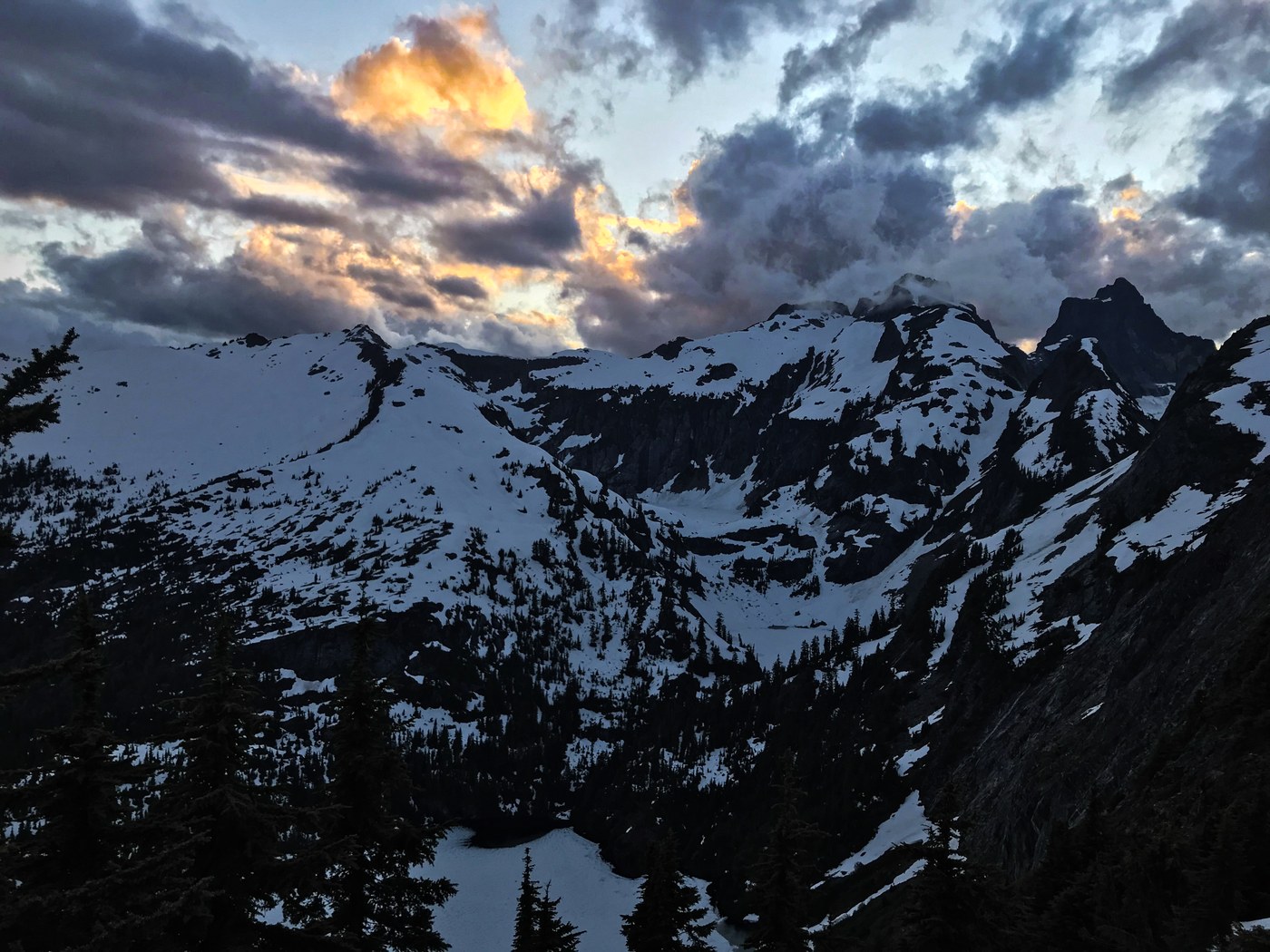
At the pass, I dropped down to the lake to set up camp. This is where I got the most twisted around. The trail down is intermittently covered with snow and less easy to follow. I covered this section multiple times during my time, so hopefully it will be a bit easier to follow now, but I found GPS very helpful here as well as keeping a sharp eye for little snippets of non-snow covered trail. This can be a bit hard to spot as the snow is weighing down huckleberry and slide alder so that it disguises the trail at times. There is a water source next to/on the trail going down as well as the lake. The snow bridge crossing the outlet of the lake is getting a bit sketchy, but if you stay to the right (lake side) of the bridge, there is a large boulder that is then met by a downed log underneath the bridge to provide solid foundation to the bridge. Avoid the left side (outflow creek side) as this is getting thin. When in doubt, probe first! There is one full campsite melted out and a couple places one could cram a bivy that are less ideal. It may take another week or so for more full spots to melt, honestly it's hard to say. The toilet is fully melted out and is quite luxurious with a great view at sunset (and doesn't stink yet, early season benefits!).
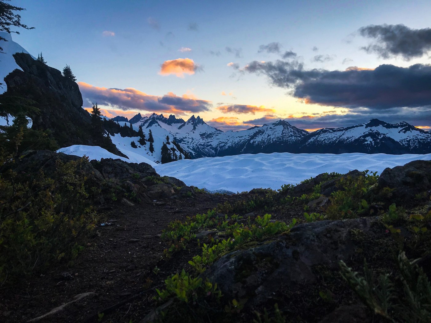
I hiked up to Trappers early the next morning to catch sunrise. The climb up is easy to follow with little issue. From where the trail splits to go down to the lake or up to the peak, follow the obvious snow covered corridor up and it will basically dump you at a melted out section of the trail that climbs up to the peak. The most scrambly bit of the trail is melted out and easily managed. There are periodic little snow fields to navigate, but it is pretty easy to always see where the next section of dry trail is. Most cornices have already fallen, but just be aware of the cornicing along the east aspect and be safe about how close to the outside edge of the snow field you travel. Overall, at least half, maybe more, of the trail to the peak is melted out. Lots of snow at the summit, but also plenty of dry areas, again just be sure to know what areas of snow are cornice and what are on the actual summit block. I spent the entire day up there including a trip over to X Mountain which involves a bit of steep heather scramble off Trappers (and a small, steep snowfield, at least for now) and then an easy traverse across the obvious connecting ridge.
Some wildflowers starting to bloom where there isn't snow. Also spotted a mountain goat, ptarmigan, some marmots, grouse, and the usual small critters. I had the entire place to myself all day and the weather was glorious. Hiked out Tuesday morning in a cloud as the weather system moved in. Again, much of the snow condition will change, hopefully making the trail easier and safer, but for now beware of postholing and false snow bridges. When in doubt probe and stay within your limits of skill. Spectacularly beautiful area and I will 100% be back!


Comments
zak_smiley on Thornton Lakes and Trappers Peak
Cool always wanted to check this out
Posted by:
zak_smiley on Jul 01, 2020 02:23 PM
nature rules on Thornton Lakes and Trappers Peak
when do you see the lowest lake snowcap being gone? great story!
Posted by:
nature rules on Jul 02, 2020 04:56 AM
abkoch on Thornton Lakes and Trappers Peak
Honestly not entirely sure. There was noticeable melt out even in the 36hrs I was there, but with the cooler weather and the way it is sheltered, I would guess at least another week before the majority of that lower lake is melted out, maybe more like 2. But with warmer weather on the horizon, I may be totally off on that.
Posted by:
abkoch on Jul 02, 2020 06:01 PM