
This was our first time climbing Mt. St. Helens, and while we had read all the trip reports and trail descriptions in our preparation for the hike, we still didn't know what to expect until we actually got on the trail. It was more strenuous and more beautiful than expected, and it was a big challenge but it felt like a real accomplishment when we were done.
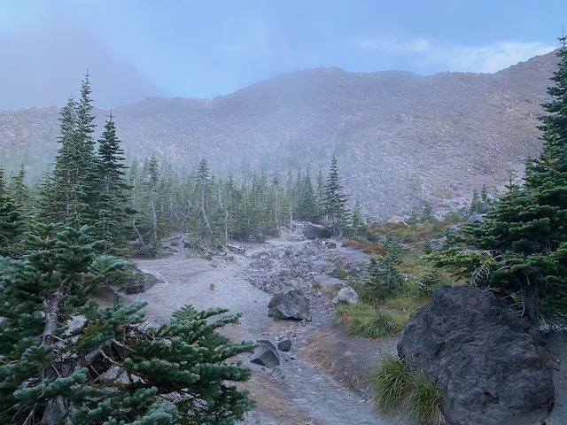
Following the suggestions on a previous WTA trip report, we opted for an early start to try to avoid the mid-day heat and catch the sunrise over Mt. Adams. Print or otherwise save your map to the trailhead because you can't rely on cell service to work outside of Cougar, although you may get stray coverage bursts on the mountain. The thick fog on the drive from Cougar to Climber's Bivouac was treacherous at times, with a rutted dirt road on the last stretch and visibility as low as < 20 feet. Be sure to write your information in the logbook at the trailhead. We were on the trail by 5:30 wearing headlamps and the forest hike felt like a breezy stroll. As the sunlight crept in, we got our first glimpses near the Loowit Trail of the bouldered ridges awaiting us.
Past the edge of the trees at the climbing permit border, we ran into our first steep ridge of boulders that would, on and off, characterize the middle third of hike. "Boulders" means different things to different people, and what we found that it meant here was hiking through stretches of dirt paths snaking up bouldered rock faces, interspersed with more vertical stretches where hand scrambling was required. The rocks along the path felt mercifully solid and stable, so while the scrambles were at times tough they never felt "sketchy" like they were going to give way or slide under you.
The choice to go early was a wise one - the sunrise was gorgeous, and later we were glad to be on our way back down before the midday heat. It doesn't take long to find yourself above the clouds and looking south at Mt. Hood and east to Mt. Adams and the sunrise view is especially dramatic.
We were in a cluster of about a dozen climbing parties that started within 30 minutes of each other and we at times took turns passing each other but overall we had plenty of room to ourselves, especially once we got further up the mountain. We had prepared fairly thoroughly, wearing long pants and long-sleeved tops, sturdy gloves to go over the scrambles and carrying hiking poles. Other hikers climbed in shorts and T-shirts or less, although they were much younger than us fortysomethings. :-) Whatever you choose for gear, be prepared in case of emergency - there are not many steep drops but there are nearly limitless sharp rocks and boulders and a chance of finding yourself up in a spot you don't know how to get down from. And once you're up on the mountain, there is no speedy way down.
So, back to the boulders... For hikers like us who were used to a well defined trail like Mt. Si, this was a very different experience. As mentioned elsewhere, the white poles provide a guide through the lower boulder fields and then up onto Monitor Ridge. You will snake along pretty well visible paths through the boulders and then find yourself staring up at a 50-100 foot section that looks nearly vertical from afar. Up close, you will find various paths through the boulders but there is no "right way" and it's worth your time to look around and try to find the best route for you. Usually a little pathfinding pays off and you will find a combination of direct routes with more hand scrambling and one or two longer paths that involve less scrambling at the cost of more walking.
We saw several "false summits" which were just the culminations of these steep rock walls where you can't see the slope above. We went through probably half a dozen significant boulder walls on our way up to the last third of the route where the boulders started to thin out and we found ourselves doing more tough walking up steep inclines of ash, gravel and small rocks. Once we were there, we noticed what looked like a ridge with a bunch of people standing on it and we were in view of the true summit.
Once the boulders were behind us, we felt the gravel and rocks give way slowly to ash. It wasn't the "one step up, half a step back" we were expecting - it was less difficult than that, but your foot still slid back a bit into the dust and gravel with each step. The steepness is perhaps the most difficult aspect, and we took frequent breaks to catch a breath. But we steadily saw the people on top grow bigger and bigger until we were on top.
Weather is always a variable here but we lucked into a beautifully clear day above the clouds that covered the lowlands so the crater and the distant volcanoes (all the way to Mt. Jefferson in Oregon) were visible. A Mt. St. Helens Institute volunteer was on hand with great facts and climbing tips, and there was a park ranger as well to check names and match them to permits! A few other parties were on hand as well, and there was a jubilant mood for everyone to have made it up and have a chance to take in the view.
The MSHI volunteer at the top helpfully suggested that the pillowy deep ash that is so hard to walk up is actually a (comparatively) breezy way to get down by sinking your heels into it. The volunteer also gave a tip to descend over the steep boulder parts using one free hand and one hiking pole to balance yourself, which turned out to be great advice. The way you go down will almost certainly not be the way you came up, and (within your level of comfort) feel free to take the time to scout out a path down that best matches your preferred descent approach.
We took 4:30 to reach the summit and 4:15 getting down (largely due to my having some fear of heights and needing to take it slow down the steep boulder sections). Took 4 liters of water each and drank 3. All in all a great experience and heartily recommended.


Comments