
Unbelievable Autumnal colors, alpine lakes, fun ridge scrambling, and glaciers!
3:45a: Left Seattle
6:15a: Trailhead
7:15a: Squaw Lake
8:05a: Peggys Pond
9:25a: Base of East Peak
9:55a: Summit
10:45a: Left Summit
1:40p: Back to car
Decided to try and take advantage of this last weather window to climb Mt Daniel. The bathroom at the trailhead was spotless and even had an air freshener! We left the TH at 6:15 and used headlamps for the first 45 minutes. The sun rays started to peek through right at the meadows leading up to Cathedral rock. Spectacular! The huckleberries were ripe and Mother Nature was showing off her beautiful fall colors. We joined the PCT for a short jaunt and side-hilled over the Peggys Pond. Deep lake and waterfalls dominated the traverse which took our mind off of the loose traverse. There are a couple of class three moves but overall it’s very easy to navigate.
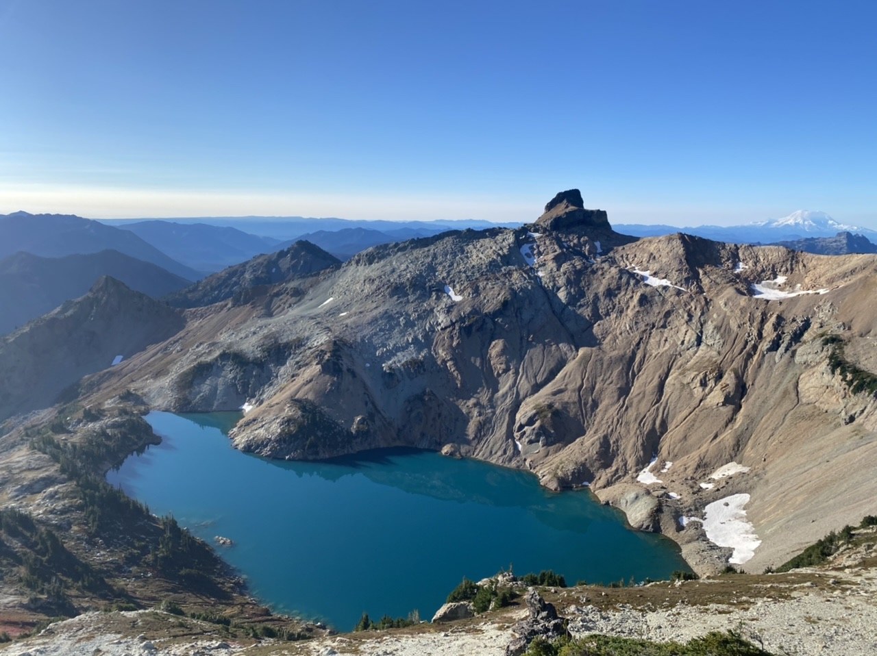
Caught the spur that diverged from the old Peggys Pond trail and took the direct route to the lake. Followed Gaia up the braided cat trails and gained the ridge quickly. We were happy to have helmets as the scree is loose and steep. Rainier opened up the left as did Circle, Venus, and Spade Lakes. Gorgeous. Mt. Stuart was imposing in the distance.
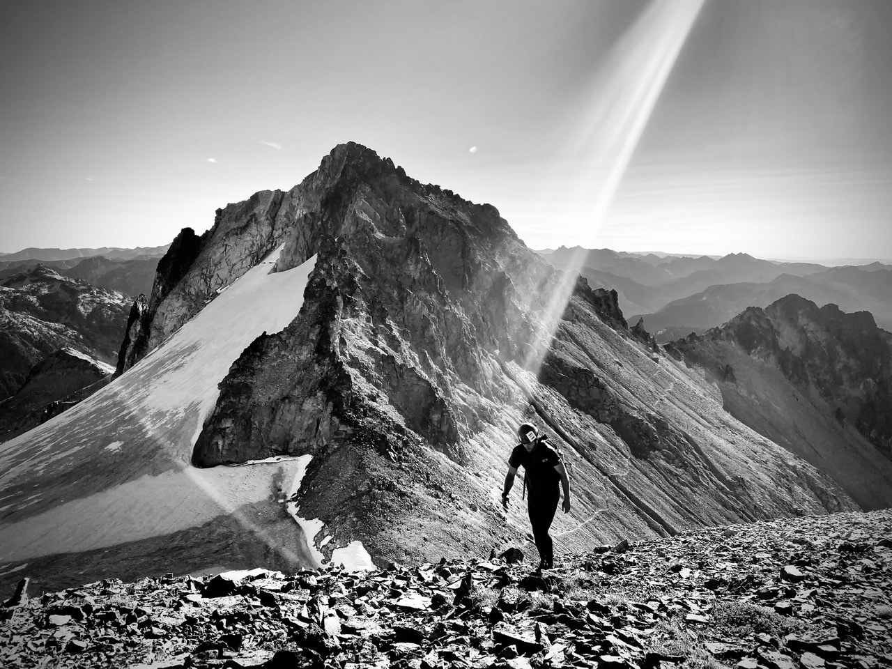
As the ridge narrowed, it got more fun and you can see the East Peak the entire time. Be aware that, that’s not the true summit although it sure seems to look like it. Around 7200’ there was a clear line to the East Peak via snow and boulders but we stayed on the ridge, mostly on the SW side of it to the base of the East Peak. The snow traverse looked sun-cupped and ripe for microspikes.
We accidentally climbed partway up the East Peak before realizing we were a few hundred feet above the main, faint “trail” to the true summit. After a little scree “rock surfing” we gained the main trail to the true summit and got there in no time, although it did look far. The last slope to the main summit is a chossy mess but it’s only about 5-10’ of work. Enjoyed the summit in what felt like 80d sun and could see the Olympics, a socked in Puget Sound, Baker, Sloan, Glacier, peaks of the Ptarmigan, Stuart, Bears Breast, Hinman, Rainier, and so on for 100+ miles. Unreal.
After about 45’ on the summit, we found the most well traveled trail back down to the base of East Peak. The 50 meters from the junction of East Peak on the climbers trail was probably the most dangerous part as the slope is steep, the trail is faint, and the rock is loose. Other than that, the mini gendarmes are easily negotiated and staying safe on the ridge is fairly straightforward if you have some experience reading the path of least resistance.
The ridge was insanely hot and I was overdressed in tights and a quarter zip. The way down was quick and we accidentally took the Old Peggys Pond trail which was tougher but easily passable.
Wonderful hike and scramble in some of the most beautiful country in the state. It seems like we got the last warm fall weather window. I could imagine it being much different with snow or in tougher weather conditions.
Note: Road is passable and creek was 6” deep. Facilities are superb at TH. Last bit of water without melting snow is at Peggys Pond. Hyas Glacier is sad looking. Ridge is fairly straightforward and if you are going for East Peak, take the more direct snowfield at around 7k feet. Look for the very faint path to the true summit at base of East Peak. We ran out of water at the summit and had no filter, so for the last 3 hours we were bone dry. Didn’t expect it to be 80d and sunny! Enjoy!
Strava link below.


Comments
ejain on Mount Daniel
Thanks for the report! The Strava link asks me to sign up for an account?
Posted by:
ejain on Oct 10, 2020 09:44 PM
NodR on Mount Daniel
You're welcome. I'm not sure why Strava is doing that. I just added the Gaia GPS track if you are interested. Enjoy!
Posted by:
NodR on Oct 11, 2020 10:44 AM
Lauren J. on Mount Daniel
Hi there! Thanks for the awesome trip report. Planning on doing Mt. Daniel this weekend. Wondering if you think this route is suitable for a dog? My dog has experience with boulders and backcountry but want to err on the side of caution. Thanks!
Posted by:
Lauren J. on Oct 13, 2020 05:09 PM
NodR on Mount Daniel
Thanks for the comment! I would say a competent bouldering dog could make it to 6600-7000’ but no further unless you put it in a backpack! There’s definitely some class III moves that would give me pause if I saw a dog doing it. I also think, given the recent precip, that there will be snow starting between 6-7k feet. Gorgeous up there regardless!
Posted by:
NodR on Oct 13, 2020 06:45 PM
Lauren J. on Mount Daniel
Thanks for the response! Sounds like my dog may have to sit this one out if we go to the summit:( One more question... do you think the snow above 7k looked skiable? We are thinking of carrying skis up but not sure its worth it. Thanks again!
Posted by:
Lauren J. on Oct 13, 2020 09:11 PM
NodR on Mount Daniel
Given the amount of new snow had above 6500’ the last few days, I would say it would definitely be skiable!
Posted by:
NodR on Oct 13, 2020 09:33 PM
Lauren J. on Mount Daniel
Oh yay! Awesome thank you!!
Posted by:
Lauren J. on Oct 14, 2020 11:28 AM