
As many readers will already be aware, the South Cascade trail is one of the rare routes available to access a destination with a glacier that empties into a glacial lake, although (as is commonplace in our modern world), the glacier no longer directly calves into the lake. (Maps have not kept pace with the melting) Such destinations are of extraordinary personal interest to me and I have tried to visit as many of them as I have been able. The terrain is typically very rugged. One of my first such hikes was a glaciological field trip to the Mendenhall Glacier in Alaska. Busy beavers had destroyed four miles of trail. It looked to be the work of monster beavers because the trees were felled while there was still deep snow and the cuts were made six feet off the ground. What a maze of felled trees and beaver ponds that was! But that was one of the most memorable hikes of my life, where I first learned to recognize in the field the glacial forms: kames, drumlins, eskers, berms, and different types of moraines that glaciers leave by their passage over the landscape and to begin to look at glaciers not merely as they currently appear, but to be able to discern their positions over time and to read the landscape as more than simply random forms.
In the North Cascades, the number of glacial lakes that still have active glaciers associated with them are few, and all pose difficulties to get to. Blanca Lake, which was formed by the Columbia Glacier when it was much larger, is easy enough to get to; but getting to the glacier itself is somewhat more difficult. The bootpath that goes along the side of the lake has some very steep sections and I injured myself once on that route. The easiest way to get to the far end of the lake is by boat, not by foot. When I went by boat last year, I got to the far end half an hour before a hiker who left on foot at the same time. Then there is Price Lake which has the Price Glacier sitting at its far end, at the base of Mount Shuksan. There is a boot-beaten path to that destination as well, one that is an extraordinarily steep and potentially dangerous hike, starting with the ford of the North Fork Nooksack, the crossing of which is located in an area of strong current directly above rapids. But that’s not all. The bootpath is hard to find and I went up the wrong side of the creek the first time I went up and had one of the scariest experiences I’ve ever had as a hiker. The Price Glacier used to be much larger and higher – the steep-side lateral moraines alongside Price Lake are five hundred feet high. This is very difficult terrain. Another rugged hike is getting to Pea Soup Lake at the base of the Lynch Glacier on Mount Daniel. The route up valley from Marmot Lake, past No Name Lake and Jade Lake and up moraine and snowfields to the pass overlooking the Lynch Glacier is extremely rugged and cannot be a route for the average hiker. I could mention a few others.
I make these remarks to make a point about the kind of trail the South Cascade trail was when it was built, is now and at some point in the future may become. There are many reasons why this trail CAN NEVER be a trail built ‘to standard’, some I will mention below. Even if there was the money to bring this trail to National Park standards, it would need expensive annual maintenance. Nature is constantly changing the landscape and this wild place is an especially good example. Many of us who are willing to tolerate a trail that is far from perfect have been looking longingly at the map for years wanting to get to the South Cascade Glacier. My hiking partner and I did not make it to the lake, we needed two nights and we only gave ourselves one. This was a mistake, but we got in farther than any recent reports for which we had knowledge. I was also on this trail in early May, went four miles in and thus was able to observe the changes on the trail since then. The human-made changes paled in comparison with the ones that nature made to the point where I didn’t recognize my earlier turn-around point when I went in. I only found it on the way out. There was still snow on the ground in May and the annual growth cycle had barely begun. What’s obvious now is that the type of vegetation that grows in the open meadows along this trail is an absolute jungle and sadly, there isn’t much that can ever be done about it except to mow it on an annual basis. Some trails are maintained in this fashion, but this is not a reasonable expectation for this trail. There is bracken fern eight feet tall, lady fern that is six feet tall and a host of spiny plants including stinging nettles, salmonberry, gooseberry and devil’s club. We whacked down as much of the stinging nettles as we could with our trekking poles, but we still got stung with nettles many times. Without permanent flagging, it will never be easy to find one’s way through this stuff during the growing season. Many of these meadows are the product of winter avalanches which prevent the establishment of forest, but as one gets close to what is known as Box Canyon, there are several gullies with even more intense avalanche activity. One of them has so much debris-covered snow that it is doubtful that it will ever melt out this season. No trail can ever be built through these gullies, it would be destroyed on an annual basis. The violence is staggering. But these gullies are so steep-walled that the current flagged route to get past them is an exhausting, time-consuming series of ups and downs that could be alleviated with better trail engineering. But the exhausting ups and downs don’t stop here. The problems that lie ahead in opening this trail will not be solved by pulling out a little salmonberry here, doing a little trail widening there and a little smoothing out of the tread somewhere else. The trail needs to be logged. That is the highest priority. How I would love to be part of a serious attempt to get those logs off this trail! The first area with major downed logs is located before the trail leaves the burned zone. The part that is in a flat area is not so hard, but the one a little farther on, located on the slope, is tough.
We camped at a location called Deliverance Creek, according to one of the maps at our disposal. Although it was early in the day when we stopped, 2:30 pm, later we were sure glad we’d made the decision to stop there. At our speed with overnight packs, it was five and a half hours from the trailhead. But this is the last water for a long time. Although this map indicated this spot was a campsite, there is no sign of previous human occupation. We found a couple spots level enough to erect tents, but it would require some terraforming to create a true campsite. In fact, we found no true “campsites” up to this point on the route. We passed a small widening of the trail at “Absent Creek” with a tiny little fire ring, but the creek was indeed absent. It is possible to camp along the South Fork Cascade River where the trail is nearby, but once the trail leaves the river, our site close to Box Canyon is the only option. We did a little exploring after we set up camp, but saved the big push for the following day.
Since I was in this area in early May, someone came in and removed much of the older flagging for the route and put in new material. We could see clearly that several people had been through before we got there. The trail through the forest up Box Canyon is steep, but easy to see where it is possible to follow. Downed logs across the trail have turned sections from steep to very steep as it becomes necessary to go straight up to circumvent major obstructions. We reached an area at about 3000’ where the grade eased and the trail entered a patch of blueberry where the tread became indistinct. Beyond this, we found more clearly defined trail and even a trail blaze of the old-fashioned kind that was made with a sharp object on a standing tree. There were steep cliffs to our left and we were seeing ever more steep drop-offs to the right. I was in the lead and finally, I saw no more trail blazes, nor any more tread. We figured something was wrong and we back-tracked. My partner’s GPS indicated that we were 300’ below the actual route. I went through a nasty patch of vine maple to search for a way up on the only part of the slope that was not pure cliff. No way could this be the way up. Next we went back to the spot where the flagging stopped and tried to push on. Eventually we reached a very beautiful spot right on the river (see picture below), but there was no possible way to move upstream from that point. No proper trail could ever go through the area without dynamite, there’s just too much steep rock. So next, we backtracked even further. We figured whoever flagged the route earlier this year got off route, turned around when they reached a dead end and didn’t remove the bad flagging. Finally, we found a place where the ridge we needed to ascend looked climbable. I scouted above the trail a few minutes while my partner, within shouting distance, found the actual turn-off. This year’s flagger went straight ahead while the actual route turns sharply to the left uphill. It was an easy mistake to make because the trail he was following was clearly defined in the moss. Why there was a trail that way, we have no idea. We put a lot of material across the bad route to discourage a repeat of this mistake. There was no doubt we found real trail. The tread was still very clear after all these years of neglect. We found the first real campsite we’d seen on a ledge above the valley with a view to a cliff on the other side. Somebody had probably used it this year to judge by how few needles and hemlock cones were resting on the charcoal in the fire pit. But, alas, no water nearby. The trail from here heads into a patch of vine maple that could use some serious pruning. Once past the vine maple, there’s not much woody material to tie flags to. Somewhere in this mass of herbaceous greenery we lost the flagging and headed up hill to traverse below the cliff. We truly regretted this. Not only did we hit ever more stinging nettles, but once past that, I got into a steep section in the trees and had a few “Oh-my-God-what-am- I-going-to-do-now” moments before reaching more secure footing. Unfortunately, even then, we were not even close to what on one map is called Dismal Gap, where we hoped to re-encounter the trail that we had lost. We went up through “Desperation Slide” and hit some of the worst bushwhacking either of us had done in many years. Everything was thorny. We pretty much gave up getting to the lake. Once at the top of the gap, we found the trail in a few minutes. And it is nice trail, the tread is very clear. Unfortunately, once at the gap, it heads into a multi-tree blowdown that we did not explore further. We had something to eat and headed back down, avoiding the terrible meadow of Desperation Slide. The trail got steeper as we headed down through beautiful forest, but still a massive improvement over the terrain we went up. When it finally exited onto the meadow, we could see this spot was flagged, but we’d missed it, despite searching, on the way up. If you lose the flagging across the meadow, just go straight across, don’t go up! Going downhill and now knowing the correct route, our return was much faster than our travel in. I am still hopeful to make it to the lake this year.
Many of the trees in the South Cascade are huge. There was one log in the creek where we made our campsite that was ten feet in diameter. Negotiating downed logs will always be a part of completing a trip along this trail. Since the last work party worked on this trail, there is now a new downed log across the road section – that is, close to the beginning. But this log is not the most important work to be done. It is easily traversed by going over and under the pieces. There will always be another log. Opening the South Cascade trail needs to be looked at as a whole, fully cognizant of the purpose of this trail. Who is going to use it? Considering how far this hike is from major population centers, it is too far to drive to unless it goes somewhere. Yes, it’s a beautiful river hike, but there are lots of those that go much farther than this one now does in its improved state. It will always remain little used until it reaches the lake. Our glaciers are disappearing and some of us are willing tough out a rugged trail to get to these places before they are utterly transformed by the climatic changes are happening and still lie ahead.


Comments
Abam on South Fork Cascade River
Exceptionally well written with excellent reflections on how what we have seen and known from the past may not be possible in the present and mostly likely the future. There is a recent article in the Guardian entitled "Is this the end of forests as we've known them? Several of the scientists interview for this article suggest that now might be the time to go to those National Parks and Monuments with large trees making the argument that these 1000 to 5000 year old specimens may be headed the same way the glaciers in Glacier National Park are headed. Your photographs captured the wildness of the area and the beauty of the water ways. Your descriptions of your efforts to traverse the trail obliterated sections certain set a challenge for those loving bush-whacking.
Posted by:
Abam on Jul 13, 2021 03:01 PM
Don Gerald on South Fork Cascade River
Thanks for your engrossing and superbly written report. Hopefully it will motivate enough of us to go out there and help get this thing fixed!
Posted by:
Don Gerald on Jul 13, 2021 07:43 PM
Nyki on South Fork Cascade River
Enjoyed reading this !! Thanks
Posted by:
Nyki on Jul 13, 2021 08:51 PM
Trailbagger on South Fork Cascade River
Excellent, in-depth report. It sure puts to shame much of the useless "reporting" of other trails on this website. Thanks!
Posted by:
Trailbagger on Jul 13, 2021 09:40 PM
C P on South Fork Cascade River
I'm tired just reading this, sounds like you are well!
Posted by:
C P on Jul 13, 2021 10:07 PM
porcupinewoman on South Fork Cascade River
Yeah, I'm still waiting to hear from you. If you want to reach to the lake, we'll have to push it back to August. My understanding from the WTA is that the upper part of the trail has been abandoned. It's up to us. There's talk of some other trail renegades working on the trail at some future date. In the meantime, if you want to do this trail, let's set the time for August.
Posted by:
porcupinewoman on Jul 13, 2021 11:40 PM
David Ryeburn on South Fork Cascade River
I can't express how much I enjoyed reading this report. C P and porcupinewoman, I really appreciate the work you've done bringing some trails back to life; I hope you can do some more work on this one soon. When younger, I used to participate in trail resurrection parties up here in BC, and if I weren't 86 now (and if the 49th parallel were open as it used to be pre-COVID) I'd be down there helping you.
Posted by:
David Ryeburn on Jul 14, 2021 04:44 PM
Eldon Jacobson on South Fork Cascade River
I also have a goal of hiking some day to South Cascade Lake. My only request is that next time label the photos. It is done during the process of importing the pictures into the WTA website. Thanks, Eldon
Posted by:
Eldon Jacobson on Jul 29, 2021 05:31 PM
porcupinewoman on South Fork Cascade River
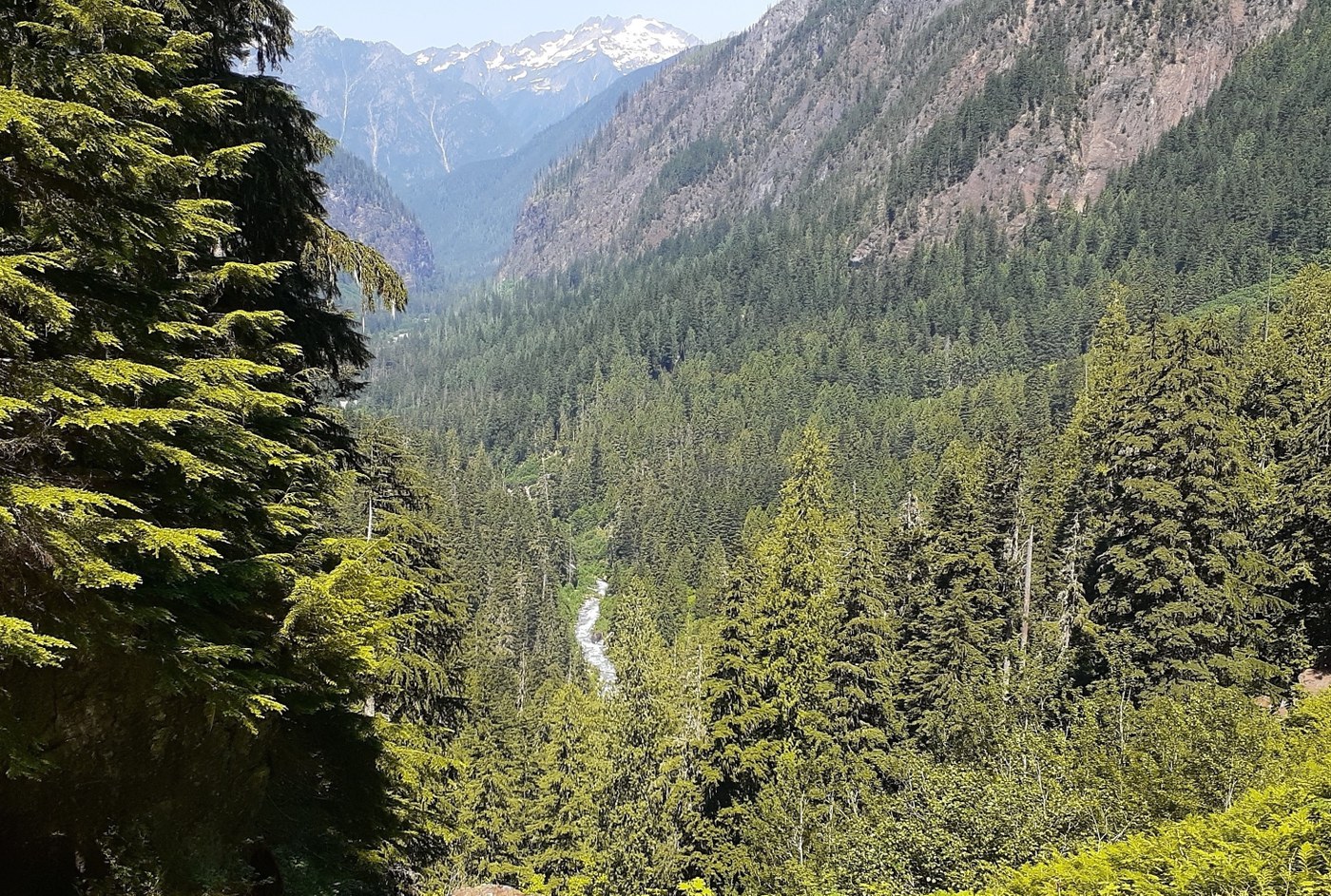
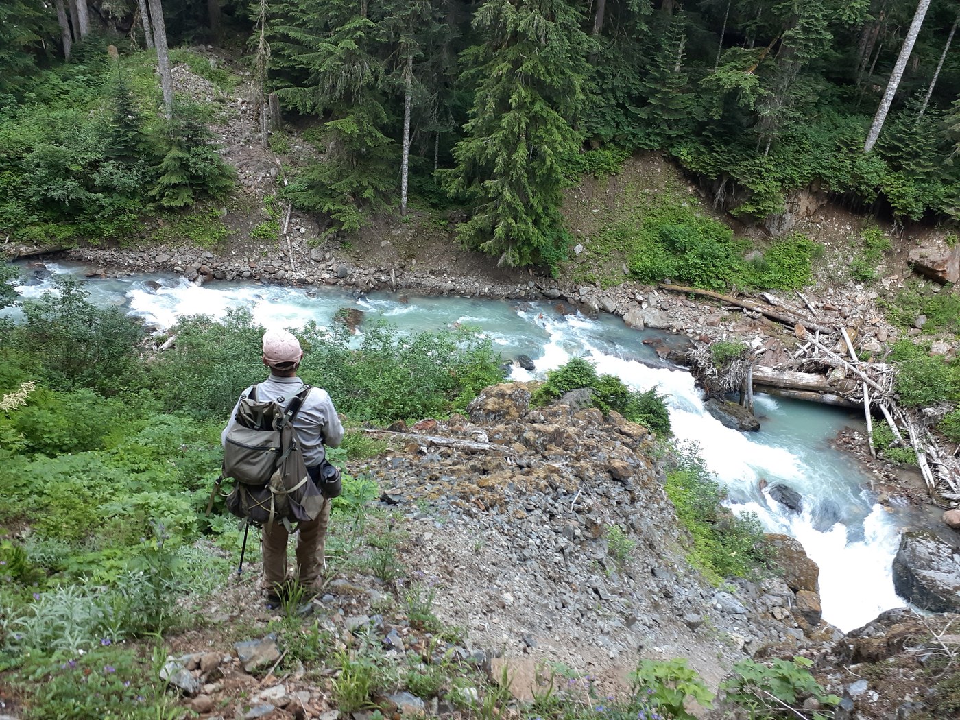
How I wish I could figure out labeling of the photos! I have tried. The top photo is taken from the open area above the campsite mentioned in the photo. The second photo is the river below our actual campsite lower down, also mentioned. The final two pictures are spots along the false route we found above Box Canyon. Good luck, I'm still hoping to get there this year too.
Posted by:
porcupinewoman on Jul 29, 2021 05:41 PM
Playapixie on South Fork Cascade River
I just had the amazing lucky of flying over South Cascade Lake in a helicopter yesterday, and found myself dreaming of getting there by foot. Your thoughtful description makes me realize just how lucky I was to see it as I did, as I now gather this is a rarely-visited gem. Thanks for sharing your experience.
Posted by:
Playapixie on Jul 09, 2024 12:29 PM