

First of all, I love this hike. It's almost worth sleeping on the couch for a week because I convinced my wife she would like it, too.
GETTING THERE
The road isn't bad. Standard potholes that a prius could navigate. Get there early for a weekend hike. There's lots of cars and no parking lot because the road ends abruptly at a wash out.
A decent number of people pack coolers in to the camping spots at the beginning of the Dosewallips trail, some people use the Dose as a starting point for thru-hiking and multi-day trips, and some climb Mt Constance from it. So it makes for an interesting mix of people on the trail.
PRE-HIKE BIKE RIDE
The first five miles and 900 feet elevation gain can be done on a bike, and you'll really appreciate the bike for the ride down. There's room under the bridge next to the Lake Constance Trailhead to stash a bike or two, and plenty of small trees to lock it to next to the trail.
THE HIKE
Mentally I break the hike into three sections: Steep first mile, false summit flat section, Steep last mile.
The Steep first mile is the longest mile in the Olympics. Half of the Steep first mile is through the burn. The trail through the burn section is better marked than it used to be. There is plenty of grid tape along the trail, so we didn't lose the trail at all. It was significantly worse a couple years ago. The second half of the steep first section follows a boulder-strewn stream (read: perpetual waterfall). After the Steep first mile, I always think, "this is the steepest two miles I've ever hiked." But it's only one mile and you're not even half way. Which leads me to... the false summit.
There's this point at one mile in, where the trail looks like it levels out and there's got to be a lake here. But there's not. On this hike, the creek had disappeared halfway up the burn section (A La Tunnel Creek), and it reappeared at this flat section (It's full flowing in June, dry in August). It looks like a nice little stream at this flat section, but it doesn't last that long. It gets steeper and steeper until it goes straight up. There are a couple camping spots along here, and I assume they're for the people that gave up on the lake because it really seems like you've definitely gone more than 2 miles by now.
The Steep last mile comes as a bit of a surprise. By now you're CERTAIN that you've gone more than 2 miles. The "trail" follows the stream (perpetual waterfall) again. This is where the scrambles start. The first one is like a gateway - if you can do this, you can do the rest of them. If this were the beginning of the trail, I think a lot of people would turn back. But at this point, you've come too far to turn back. This must be the last section, right? It's not. There are a few points in the trail that makes you think "we go up THAT?!" I saw a dog up there once (no dogs allowed on this trail BTW), and I still don't know how it got up and down some of it. When the trail description says that you need sure footing and no fear of heights, this is the section it's referring to. Pictures don't do it justice, and people don't understand when you try to tell them about it. Been up Mt. Walker? Double it. Seriously. Twice as steep. I bring hiking poles for the way down. I need my hands for the way up so I don't fall over backwards.
This trail is basically an introduction to Mountaineering. If you like this trail and can imagine doing it on an exposed mountainside with a 3000 foot drop, you'd love mountaineering.
MILEAGE
The mileage of this trail is a lie. The internet says 1.8 miles. Going up with packs on was so slow that my GPS said 4 miles. I think this is from the signal bouncing around and is just inaccurate. On the way down, the same GPS said 2.5 miles. I'd believe this number. If you draw a straight line on google maps, it looks like 1.5 miles as a crow flies. The hike is not a straight line, and the Google machine doesn't take into account 3/4 mile of elevation gain. So I'd reason that 2.5 miles is more accurate. But if you're asking yourself "are we there yet?", the most accurate way to gauge your progress is using elevation. Park the bikes at 1400 ft and the lake is at 4600 ft.
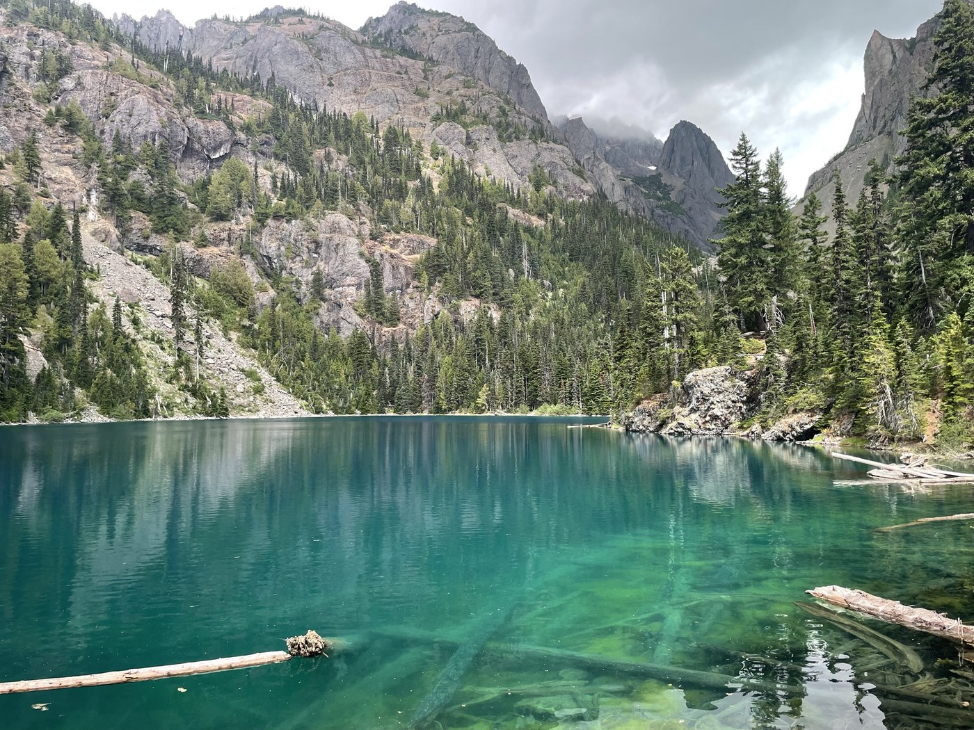
THE LAKE
The Lake is absolutely gorgeous. It's crystal clear, a unique blue, with an epic mountain scene on all sides of it, and fish are jumping everywhere. I've read it's one of the most over-populated alpine lakes. If you can present a fly well (a must for skittish high alpine fish) you don't need to bring dinner. A red wedding ring with a small spoon produced fish quickly, too.
I'm always surprised that anybody else is up there. I think it's usually mountaineers aiming for Mt. Constance and a couple of crazies that like to challenge themselves. And maybe a few that just don't know any better.
We did run into another group that had come over from the Tunnel Creek trail. They had done it 6 years ago and this time they regretted it. Sounds like it's not really a trail anymore.
Comments
Anthonyh4949 on Lake Constance
Amazing trip report, thank you
Posted by:
Anthonyh4949 on Jun 07, 2022 02:02 PM
babettelafox on Lake Constance
So helpful. I so want to do this one and am so terrified of heights (I get dizzy and feel like I’m going to jump) so this helps me gauge the real risk. Thank you.
Posted by:
carriebancroft on Feb 04, 2023 11:56 AM