
This trail get few reports, only 1 other so far this year, so I thought I would offer an update. Hiking this unofficial and unmarked trail offers stunning views of Mt Baker and the N. Cascades when the weather is clear, but the access road and beginning of the trail are both quite challenging. Loads of ripe huckleberries and blue berries right now, and very few bugs.
I usually hesitate to post reports on little known trails with big payoffs for fear of making them too popular. In this case, the difficult road and first mile of the trail will probably keep all but the most intrepid away. For those, here are the current details:
The road, FS-1130, is truly awful and entirely unsigned except for a small marker where it leaves the Baker Lake Road, about a quarter mile north of the Boulder Creek Campground. At the first fork, in about 1.5 miles, you bear right, and then left at about 4 miles, where the right fork goes to Baker Hot Springs. Up to that second fork, the FS apparently clears but hasn't graded in quite a while. The potholes are as bad as on the infamous Mt Pilchuck and Summit Lake roads. After the second Y, what is now more of a track than a road seems to get no official maintenance since the FS reports status as "unknown." Someone did apparently clear several trees that fell over it last winter by sometime in July this year. The track is actually smoother than the road down lower, but it is extremely narrow and overgrown. I don't think I damaged my paint job, but I was quite careful. High clearance is absolutely required. My later model CRV has 7" clearance and in one area near the end I scraped a little the dirt burm in the middle of the track a few times, though I think without damage. The two other vehicles in my party, with 8.5" clearance, had no problem. Almost no pullouts, so when we met two large pick-ups coming down the road, it was a bit of a problem. There was nowhere behind us anywhere close to pull over, so the trucks finally backed up a little and drove into a grassy and brushy area enough to allow us past.
At the end of this track is the totally unmarked trailhead. What was likely once a clearing for loggers holds maybe 10-12 vehicles if they park intelligently. There were two other vehicles when we arrived and two different ones when we left.
The beginning of the unsigned trail is across a burm and somewhat hard to find. A couple of painted arrows direct you across another, smaller clearing, to an indistinct path where you quite quickly turn right and upwards. No trouble following this unofficial bootpath thereafter, but it is steep and rooty. Many, many muddy patches which can be tricky to negotiate when they're also steep. Trekking poles are highly recommended and bring a change of shorts or pants for the drive home! On the other hand, the couple of trees across the trail were not too difficult to get over, under, or around.
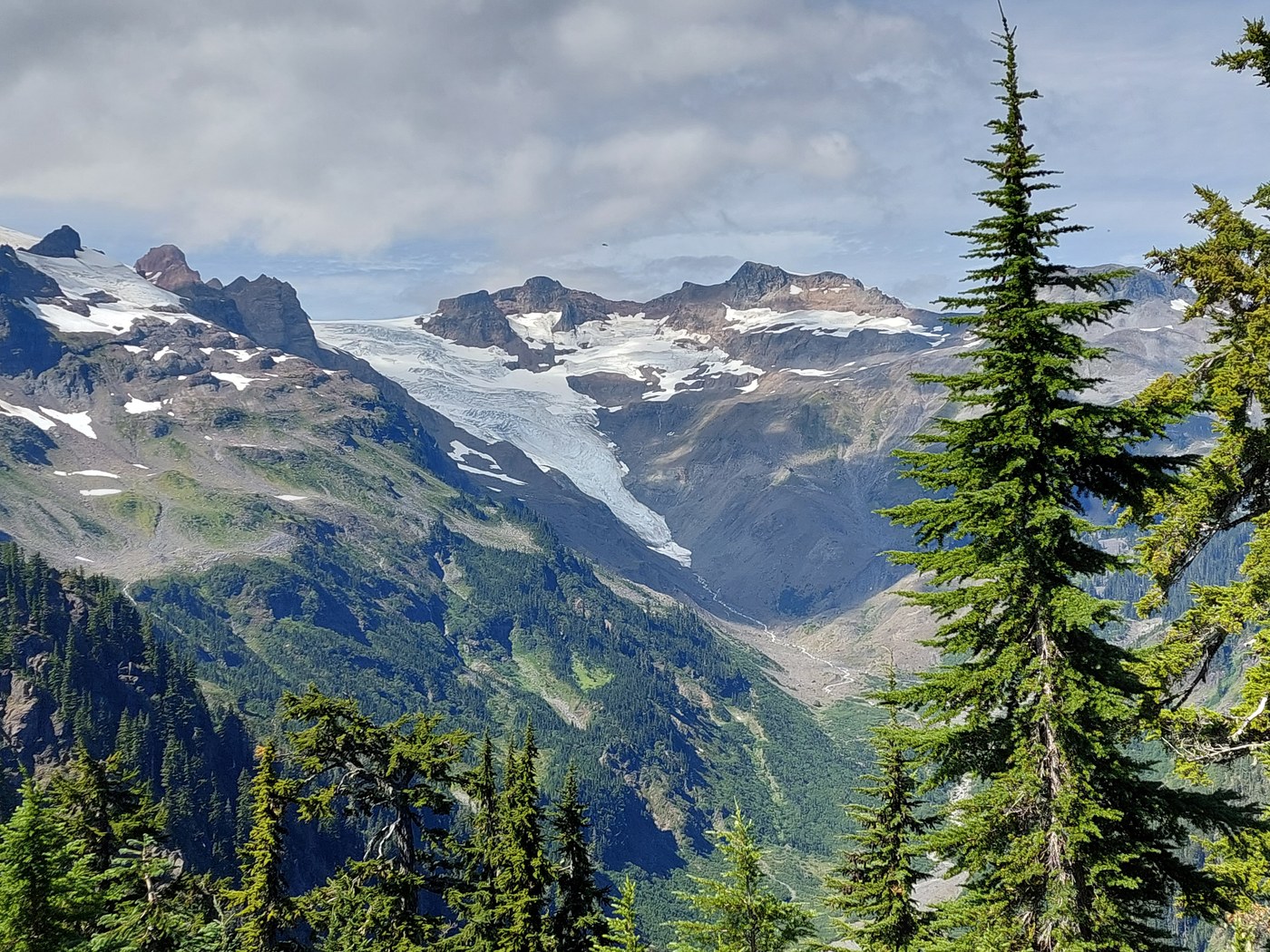
This part of the trail climbs almost 1000 ft in a bit less than a mile until you emerge on to the ridge, where the stunning views start. To the right is Shuksan up close, with the Pickett Range and many more to it's right. Straight ahead is Larrabee, American Border Peak and many others. To the left, of course, rises the mass of Baker, still with much more snow than the other volcanoes of WA.
Wondering along this ridge is truly heavenly. Trail is mostly easy to follow, though there are a few side paths into campsites and to views, as well as a couple of steep ups and downs. There is no distinct end of the trail, though around 2.5 miles from the TH it gets to an area of cliffs where some scrambling is required to continue. We, like most hikers there, chose to turn around before then. At this point, you get great views of the Rainbow and Park glaciers on Mt Baker.
We saw only 6 other hikers all day, and one polite bear hunter, who stated that he had two buddies around but we never saw them--nor any bears. We were mostly wearing bright colors, which thus is recommended. There are several possible campsites with amazing views, but no water. Lastly I would note that volcanoes create their own weather and a cloud often develops and sits on this part of Mt Baker when it is totally clear everywhere else around. Yesterday we only saw all of the elusive Kulshan at the beginning and end of our hike, with the pic I post of it actually from the trailhead upon return. There were uninhibited views of everything else, but the effort getting to and climbing up this ridge would not be worth it on a cloudy or smoky day.
One last note is that this hike appears in no currently published hiking guide or on any map, explaining why it's so little known, but you can find it on Alltrails and GAIA.

Comments
It sounds like this road has gotten even worse than it was when I coaxed my Chevy Cruz up there 9-28-2020. Your posting is only the second since mine which I guess reflects the difficult access. I didn't even try to describe the very start of the trail as it was not a very obvious entry point and I couldn't think of a good way to describe it. The painted arrows you mentioned are either new or I just missed them in the early light last year.
Posted by:
dchk on Aug 31, 2021 07:30 AM
The road is definitely worse than when I last went up there several years ago. In the same vehicle then I had no problems and it didn't take almost an hour to drive those 9 miles on road 1130. Potholes on first part are much deeper as well as more numerous and second part is considerably more overgrown. Forest Service must only maintain this road at intervals of 5 years or more, if then, except maybe for clearing obstacles on the lower part once snow melts each summer.
Posted by:
OVhiker on Aug 31, 2021 12:58 PM
Just a heads up that Ron Roosma with support from volunteers from Citizens for Forest Roads (CFFR) brushed the road twice Oct 31/Nov 2. No guarantee your paint job will be safe (slide alders are growing sneakily horizontally rather than vertically = brusher doesn't "get" them), but it is greatly improved! Pot holes still bad... Check out pix on https://www.facebook.com/CFFRoads/
Posted by:
Tussilago on Nov 06, 2021 12:56 PM
Thanks for posting that helpful info!
Posted by:
OVhiker on Nov 07, 2021 07:29 AM
Thanks for the info, going up there in Aug.
Posted by:
Gator22 on Jun 29, 2022 12:52 PM