
Phenomenal trip with five accomplished mountaineers and myself, as we all got up to Mountaineers Ridge highpoint. Absolutely beautiful day!
We got an early start at 6:30am. Parking lot was about half full, with more cars arriving as we got started. No blowdowns on the trail until we took the cut off to Lake Stuart, where we ran into a couple of significant trees down across the trail, with a few other smaller ones.
After taking a break at Lake Stuart we followed the trail towards the inlet to the lake. We started to encounter snow in the forest here, and lost the trail multiple times. The inlet stream to Lake Stuart winds around where we crossed, so we crossed it on a log a couple of times going up, but we were more efficient on the way back, as we only crossed it once.
Once out on the talus slope, we did a rising traverse to get to the far right couloir. From afar this couloir looks impossibly steep. Once we got closer it still looked super steep, but at least doable. Just below the couloir the snow was very soft, and we were constantly post holing in the voids of the snow-covered talus field. Once at the base of the couloir the snow had hardened, so we all put on crampons, donned our helmets, and took out our ice axes for the 800ft vertical ascent up, with the last 100ft being the steepest section. We thought that we were done with the steep snow ascent, but we still had to ascent another super steep snowfield 200ft vertical to get up to the rock scramble up to the summit.
Once you get up this steep snow field you come to the base of what appears to be the summit block. This is the false summit. At the base of this follow it to the left, and there will be a short scramble up. Maybe 30 ft up of class 3 scrambling, with one class 4 move, with a bit of exposure. Especially for short people. Once up at the top of this it is a class 2-3 scramble up to the summit.
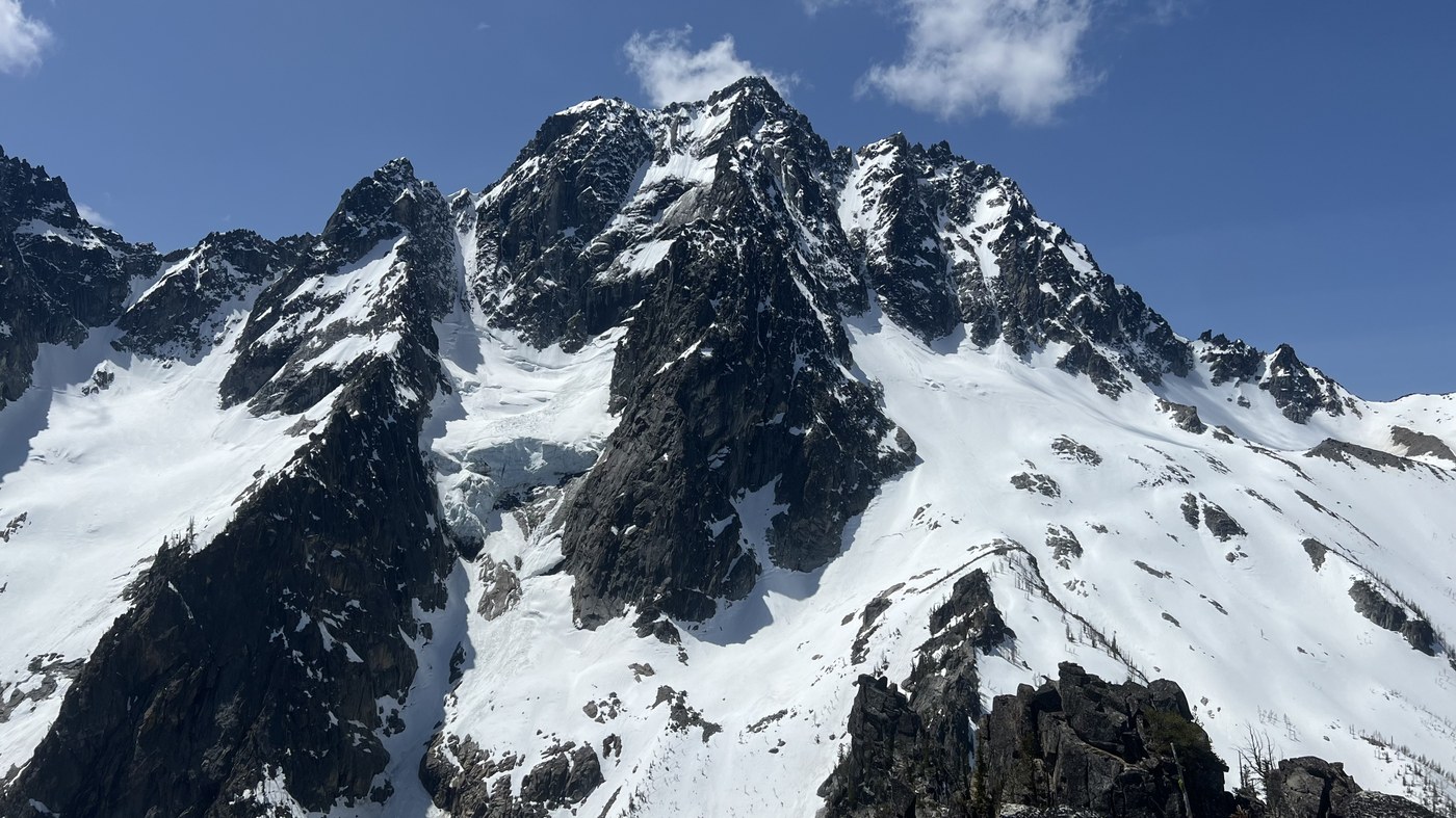
The summit has some incredible views, especially of the northside of Mount Stuart. We could hear some rockfall, and saw an avalanche coming down that looked like a waterfall. We also had some fantastic views of Colchuck, Argonaut, Sherpa, and many other peaks, along with looking straight down at Lake Stuart, and seeing the snow covered Horsehoe Lake.
Coming down was quite the chore. We just took our time with the down scramble off the summit block. Once down from this, we put our crampons, and slowly went down the steep snowfield to the top of the couloir. Here we set up a hand line, and used a prusik to safely get down the first 100ft of the couloir. From here we carefully went down this super steep slope, alternating with face in down climbing with ice axes and crampons to carefully zig zagging down, using our bootprints from the way up. Once down to the base of the couloir, we then postholed on down to the creek crossing, and had the long hike out to the car.
We arrived back to the car 6:25pm, almost 12 hours later. The last couple of miles seemed to last forever. We joked that " I think they added a mile to the trail" haha! 12.2 miles with 3900ft elevation gain


Comments
Stuke Sowle on Mountaineer Ridge, Lake Stuart
Great shot of Stuart! That serac is something else.
Posted by:
Stuke Sowle on May 25, 2025 11:46 AM
kidz won't hike on Mountaineer Ridge, Lake Stuart
Thanks Stuke! The view of Stuart was something else. The picture isn’t even zoomed in, as it was so close!
Posted by:
kidz won't hike on May 26, 2025 04:51 PM