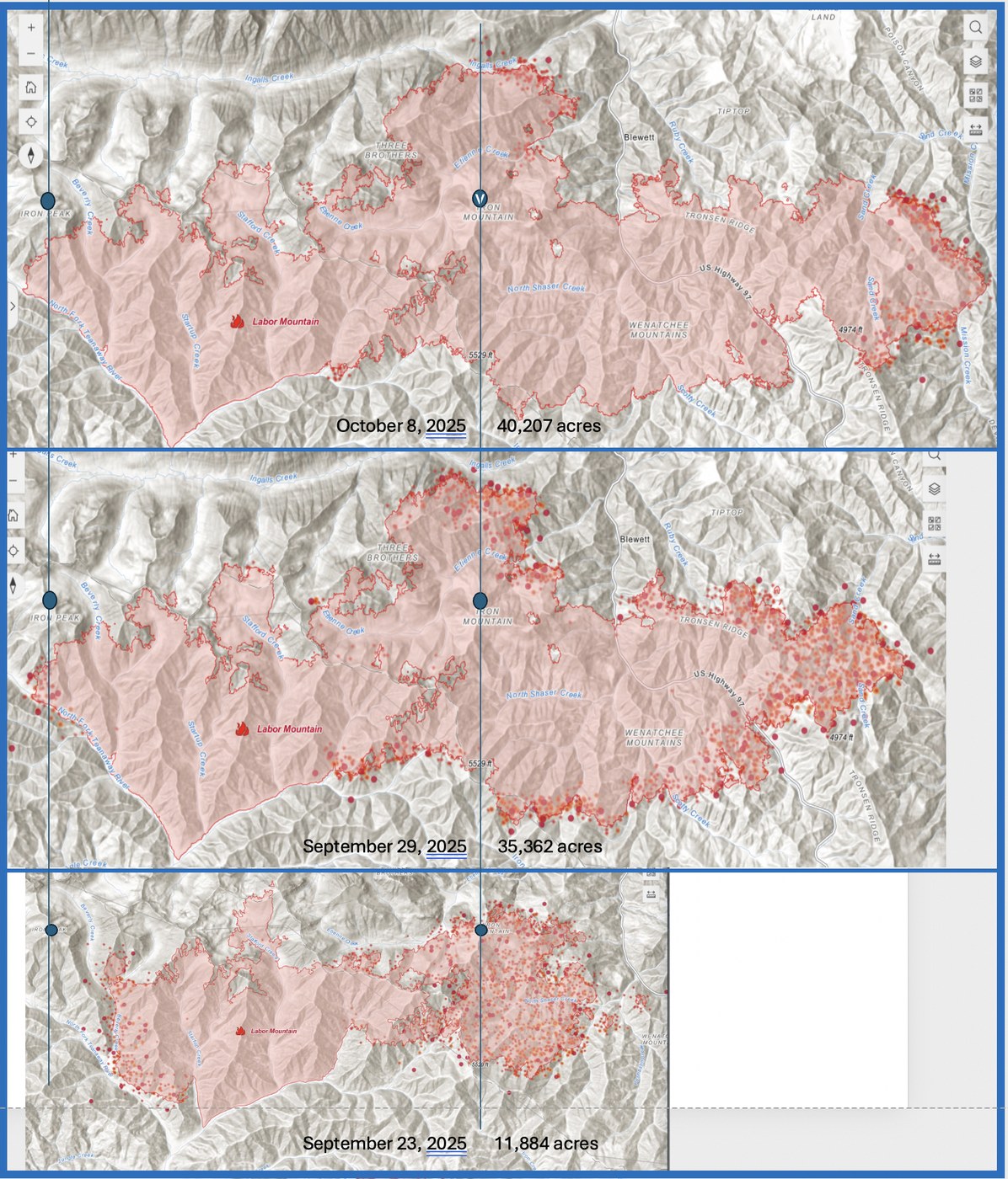
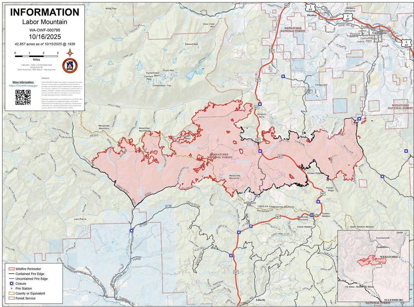
October 16 (8:30 pm): Fire is now 42,857 acres. Highway 97 is open and has no restrictions either north or south bound. The closures for forest access roads remain (and shown by Xs in the fourth figure from Oct 16. The Xs on US97, t for 97, but are at junctions for USFS Roads).
October 9 (8:22 am): Fire is now 40,586 acres (~380 acres from 24 hours before). Fire and heat have greatly abated and indeed some of the heat is coming from a series of backfires including those along Stafford Creek, Ingalls Creek, Tronsen Ridge, and Mission Creek, all in an effort to firm up fire lines in anticipating of strong winds as these fronts roll in. I re-read my trip report for October 8, 2024 (Ingalls Pass and Lake) and noted that I left Seattle in a downpour and was treated to blue sky east of Iron Peak and mist and rain drops, thanks to very strong winds, from clouds over Fortune Peak.
The shut-down and the landscape recovery plan for every fire means that the current closure boundaries will remain in place for some time. Air quality is much, much better.
October 7 (3:14 pm): US Highway 97 open with a pilot car (expect long delays, but road is open). Still lots of heat and terrible smoke; fire continues to move eastward. Fire grew by about 500 acres from yesterday (now at 39,753 acres). Smoke on either side of central Cascades has resulted in very bad air quality.
Recommended web sites: https://wasmoke.blogspot.com/ , https://experience.arcgis.com/experience/6cdda73cf6154949a1fae76ccb2900a0 , and https://inciweb.wildfire.gov/incident-closures/waowf-labor-mountain-fire .
October 6 (9:07 am): Three important points regarding the fire and access to the area. First, the rains, increased humidity, and lower temperatures all have helped (fire size only increased 4,000 acres in the last week); however, Sunday, October 5 was clear warm - the DNR heat map from 7:00 pm yesterday shows considerable heat in the Ingalls Creek and Etienne basin in the central, north of the fire extent, along US 97, Tronsen Ridge, and Mission and Sand Creeks on the eastern edge. All previously active Washington State fires were producing considerable smoke, yesterday. Today and tomorrow promise warm (and in the sun, hot) mid-day to evening heat enhancing fire activity. Second, we are in the beginning of a government shut-down, which will affect how fast the area in the fire and along its perimeter are recovered and USFS roads and trails will be re-opened. Third and most critical, roads and trails in and along the perimeter are dangerous -- there are still hot pockets underground where the root system continues to burn. Tree and slope failure are easily triggered -- time alone will trigger tree fall, rock fall, and slope failure. Unless you are prepared to fight a small fire, move a very large rock, or cut through a 30 inch diameter tree that falls across the road you easily drove in the morning and now want to go home, honor (obey) the closures.
September 29 (4:10 pm): Winds are pushing this fire E and NE. Size has increased by 10,000 plus acres. Rain will help, the question remains, how much?
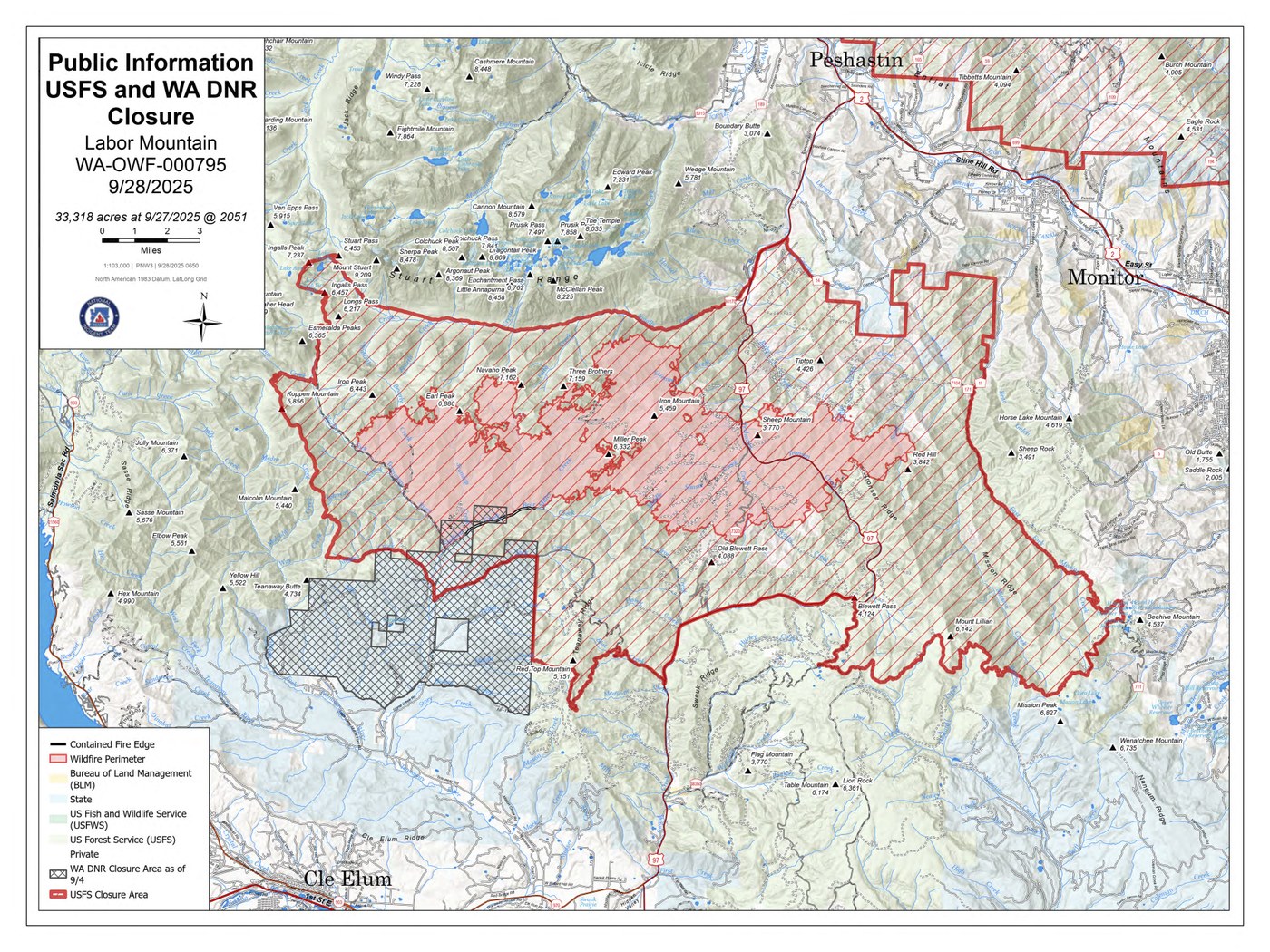
* See new closure map that includes USFS and DNR lands
* Recommended web sites: https://wasmoke.blogspot.com/ , https://experience.arcgis.com/experience/6cdda73cf6154949a1fae76ccb2900a0 , and https://inciweb.wildfire.gov/incident-closures/waowf-labor-mountain-fire .
Note: To the SW of the Labor Mountain fire, is the remains of the August 2017 Jolly Mountain Fire -- this can border can be easily seen at the confluence of Johnson Creek and the North Fork of the Teanaway. NE, E, and SE of the current fire are other older fires. These can make nice fire breaks or because of the nature of remain fuels, can be excellent places for the fire to grow and expand.
September 26: Strong winds associated with the passage of a cold front on September 25 brought about a 10,604 acre or a 16.6 square mile increase in size of the Labor Mountain fire (see scaled Figure 2: two summits are indicated for comparison purposes and these are Iron Peak and Iron Mountain [also known as Iron Bear]). Hopefully the 'promised' rain of the coming days will help otherwise waiting for snow may be the only end to this fire as well as the others.
Closure of this area and perhaps some of the area around the Sourdough Moutain fire will put a lot of pressure on the Highway 20 subalpine larch viewing hikes. Not a pretty picture. As an aside, soon after coming over Washington Pass yesterday, a ridge facing east on the north side of the highway had a line of subalpine larch that was beginning to show clearly autumn colors.
September 24: With the new DNR heat map shows consider fire growth and heat upslope of the North Fork Road between Stafford and Beverly Creeks (see 'oval'). These changes are mostly likely due to back-firing where fuels are being ignited by firefighting personnel in order to reduce fuels and thus create a fire. Red dots and lots of red dots on the opposite side of fire-lines likely indicate that the line has no longer held. However, it is important to remember the spatial scale of these dots (satellite derived dots are somewhere in a 1 x 1 km pixel. The heat dot is mapped in the middle of the pixel although the actual fire producing the heat might be in the upper NW corner of that pixel). If the dots are derived from airplanes or drones, pixel sizes decrease dramatically.
I encourage everyone to use the DNR Fire Dashboard (https://experience.arcgis.com/experience/6cdda73cf6154949a1fae76ccb2900a0 ) and to acquire the 'free' app entitled 'Watch Duty' -- it covers western US and you can either notifications sent to your phone by either selecting a fire or a county or region. In addition, you can subscribe to receive your county's emergency alerts. Can be critical in a least three noted cases in the last decade where relatively small fires grew and moved either south or down valley at speeds faster than most of us can run.
September 23: Just on the doorstep of fantastic autumn colors, the Labor Mountain fire blows up over the weekend. Highway 97 is closed and the North Fork of the Teanaway Road is also closed. This is one of my favor places in the Cascades, I have visited here almost a 100 times between the summer of 1967 and May 2025 (class field trip to Iron Peak) with family, friends, and students from the UW. You will find the DNR fire map for September 23, 2025 with colored dots that indicate the location of heat and its intensity by both the size of the dot and the intensity of red. Peaks such as Miller, Earl, Navaho, Jester, and Iron Bear have been previously visited by me and now this fire!
I have added the most recent USFS closure map for the area impacted by the fire including the North Fork of the Teanaway as well as the current USFS Fire Extent map. The black line is the 'containment' fire line.


Comments
Just an update on the closed area boundary. It is much larger now than the above map:
https://www.fs.usda.gov/r06/okanogan-wenatchee/alerts/labor-mountain-fire-fire-closure-order-updated-sept-10
Posted by:
John Morrow on Sep 23, 2025 01:38 PM
This is the location of the WA DNR active fire heat map, thanks Abam for showing us that information. I was unaware of it:
https://experience.arcgis.com/experience/6cdda73cf6154949a1fae76ccb2900a0
Posted by:
John Morrow on Sep 23, 2025 01:42 PM
Key after you open the above url from John Morrow is to click the box that states: "I recognized the intended use of this dashboard..." One of the nice things about this dash board is that it often includes data from Southern British Columbia. There is a separate BC Fire Map and its url is: https://wildfiresituation.nrs.gov.bc.ca/map .
Posted by:
Abam on Sep 23, 2025 02:21 PM
I'm really bummed. Witnessing 35 years of fire in Kittitas and Yakima Counties, this one is hitting me the hardest. I fear the rapid wind driven growth has been so fast and hot that it is consuming everything. Much like Schneider Springs. I had hoped for a while (before the two cold fronts with the frontal winds) that the intensity was low/moderate in the valleys and some of the big old Douglas firs and Ponderosa Pines survived with underburn. Not sure now. And it has reached the few subalpine larch in the area. Hope it is ground fire under those since there is not much vegetation. It has burned through Upper Stafford Meadows and Bean Basin Meadows. Will any trees have survived?
Posted by:
John Morrow on Sep 26, 2025 11:00 AM
So far, Iron Bear is not listed in the Burn area; however, Jester is. Iron Mountain is not Iron Bear.
Posted by:
Old Rod on Sep 27, 2025 08:56 PM
Thank you for this correction: Iron Mountain is not also called Iron Bear. Iron Bear is located on a ridge just south of Jester (https://www.peakbagger.com/peak.aspx?pid=25572).
The area of the Labor Mountain Fire is now greater than 33,000 acres.
Posted by:
Abam on Sep 28, 2025 10:24 AM
I am still unclear from this information if the actual road and trailhead to Lake Ingalls is open, and if the trail is still open for hiking. Seems like it is closed, but has anyone tried driving there in the past few days?
Posted by:
Special J on Oct 05, 2025 12:10 AM
Yes, it is definitely closed. The fire edge has reached the road and it is acting as active fire line with firefighters holding that line to protect the cabins and prevent spread west of it. The lower Teanaway Community Forest is open. The black crosshatched DNR Closure of the TCF begins beyond the private homes at around Lick Creek. Well south of 29 Pines Campground. Hope that helps. Big closure areas descriptions can be confusing.
Posted by:
John Morrow on Oct 05, 2025 05:51 AM