Trip Report
Wing Lake, Louis Lake — Friday, Aug. 28, 2009
 North Cascades > North Cascades Highway - Hwy 20

Started Friday Morning, returned Sunday evening Aug 28-31 - 3 cars were in the entire parking lot at 8am Friday. There has been Bear activity within the last few weeks with signs posted all over, perhaps this has persuaded folks to stay away?
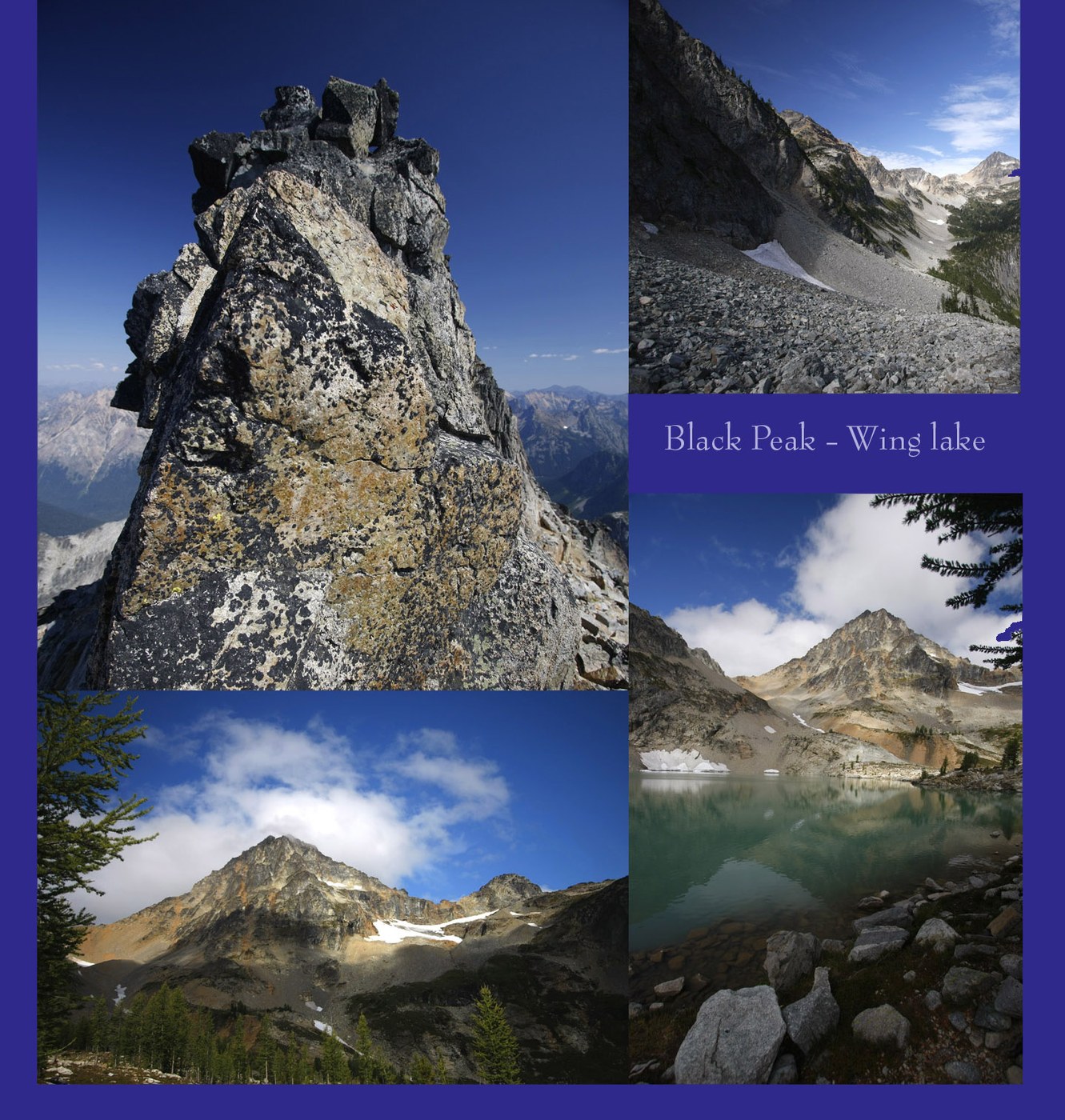
Journey Brief: Enroute to Black Peak, camping at Wing Lake, passing Lake Ann and Lewis Lake.
Trail to Lake Ann is easy, few switch backs, gentle grade for the most part. Good place for kids - but there are a couple places where you won't want little johnny getting too close to the trail edge as he won't enjoy the 300' drop. Continue on up the trail along the valley side past the Lake Ann, also an easy grade, and wide trail, to see great views looking down on Lake Ann. The views at the top Heather Pass only have peek-a-boo views of the lake, the best views are along the way to Heather Pass. Once at Heather Pass you could continue up the trail as if to take the rainy pass loop and catch some more great views once you get above the tree line. I departed the rainy pass loop at Heather Pass and headed for Wing Lake and eventually Black Peak direcly above Wing Lake. you can see Black Peak and the Wing Lake basin in the distance and lewis lake in between. Its worth going to Heather Pass if the weather is clear to see the view of Black Peak, Wing lake basin, Lewis Lake and and the boulder fields between you and them.
Once you depart Heather Pass towards Lewis Lake and beyond (you can see lewis Lake almost the entire time you travel towards it) you immediately leave the park trail and endure a moderatly rugged boot trail that mostly drops in elevation until just before you arrive at Lewis lake. This trail would be slippery as snot when wet and there are 3 or 4 places where it is real steep. Not an issue overall but it would be a pain for overnight backpackers carrying a load.
The route from Heather Pass to Lewis Lake is also charmed with millions boulders. If you stop for a second you can hear Gandalf the Boulder God yelling 'you shall not pass'. Day hikers can probably hop through this section (3 sections actually) easy enough but it sucks for backpackers. Going down hill to Lewis lake is worse than coming back going uphill. There is supposed to be an alternate route that drops below the boulder fields, I didn't see it. Backpackers should take into account the time to cross this section. I didn't enjoy this section at all. pity the soul that is wearing tennis shoes.
Water, late August and there was no water on the trail from the trail head until Lewis Lake (unless you go to Lake Ann) Lewis Lake which is fed by near-by run off is also fed by Wing lake, which is silty. Both Lewis and Wing Lakes are very silty, still pretty blue/green but very silty. Unless you ventured off trail to fresh water coming off the mountain somewhere there isn't fresh water on the trail until you reach Wing lake, there you will find a fresh creek that appears year round on the far side of the lake just below the flanks of Black Peak, run off from a permanent snow field above. I used water tablets and drank the silty water, not the end of the world. just fyi.
This place was supposed to be a busy and crowed place yet this weekend it was not - Bear? There was supposed to be a thunder storm Saturday that never materialized too. There were 2 guys camping Wing lake Thursday night that left Friday when I arrived, and 1 couple arrived an hour after me Friday afternoon and stayed 1 night. They summitted Black Peak Saturday Am and left shortly after. A group from Canada arrived Saturday afternoon, about 12-15 people total and set up camp on the far side of the lake. Just this group and I Saturday night, and as large as this group was, it still felt like the place was empty. Sunday Night I had the place to myself. Lots of places to tuck away at wing lake too. Don't hesitate to go hear fearing no campsites, literally dozens of places to set up, all spread out most with an 180-270 degree view to the North and East.
There are only a handful of campsites at Lewis lake though. Wing lake is definitly a better place to camp. Its worth the extra hour and elevation gain to Wing lake. Lewis Lake is completely rimmed with boulders and the views are not as easily accessible from some of the tent sites as they are at Wing Lake.
Bugs were very tolerable on this trip except right at Wing Lake, swarms of Mosquitos hovered here and there, mostly near dried up tarns. Once you left the lake edge towards the surrounding areas where you would be likely to camp you leave the majority of bites behind, at least in late August.
Summitting Black Peak.... A person with NO rock climbing skills can do this, but it helps to know the route. Nice to have a helmet if you have one, especially if in a group. Here is what I learned. Direcly from Wing Lake follow the creek on the lake side, up to the low side of the Morraine you can see. The Morraine is about half way up the basin to the Col directly at the bottom of Black Peak where you would want to start climbing the ridge you can see from down below. Once you reach the low side of the Morraine (left side) you can walk a permanent snow field about half of the way up from there, real nice. It will appear that you can or should take the mountain side of creek up to and past the Morraine, and you certainly can, but you miss the snow walk which is really nice and easy and worth doing.
Near the top of the snow field you have to find a route up to the col. True rock climbers can probably climb up several ways but for us weekend warriors you want to head up the chute that looks like it just takes you up through a little dirt area between rocks on the left and the right. This easiest place (col) isn't the lowest point on the ridge either, it is to the right of the lowest point. From a distance it will look like you could just walk right up this chute to the Col. Up close it is a different story. I found that if you get to the top of the snow field, or real close to the top there are dried out drain ditch chutes about 1 to 3 feet deep and wide coming down from about 20 degrees to the right of the chute you are attempting to go up. If you climb the last drain ditch, or second to last drain ditch you will arrive near the top where you can cut left across some rock outcroppings. Climbing the drainage ditch channels is kind of nice, the loose stuff is washed out and most of the rocks are stable. One of the pictures on my website has the trail I took lined in black. It is not apparent from the bottom of the basin that you aim about 20 degrees to the right of the col and cut over at the top just below the rocks cliffs. This is the easiest way up and down.
Once at the col you head up the chute that runs just directly behind the ridge that you have been looking at all the time from Wing Lake. There are several ways to get up the chute to the summit but the easiest (safest?) is to stay to the right almost all the time and use the bigger stable rocks to help get up, nice deal. here is clue....when I came down from the summit I looked to go down the "left side" of the chute and found myself going down the wrong chute altogether.... If you can see the lake you are going down the wrong chute. When you were going up along the right you never really saw the lake at all did you? because the ridge/rocks are always blocking your view on your right until close to the very top.
Summit... there is a huge flat area at the top just below the actual rocks that form the true summit. spacious area to relax and walk around. Going to the actual summit takes about 2 more minutes.....climb along the edge of the summit rock with views of Wing lake below and scamper up a 'rock-crack' so to speak. At this place you will find that you will feel exposed transitioning from the sides of the summit rocks to the place where you want to start climbing up. go for it. Once on top (about 10 seconds later), you have to cross the summit block (about 10 seconds ahead unless you have a fear of heights and are frozen stiff) to reach the true summit (other side of the crack) which is like 10 feet higher then where you are right now. I crawled on my hands and knees and scooted on my butt across the summit block and it wasn't that hard. I probably am not the only sphincter that has squeezed this rock crossing :)
Amazing views - worth the effort - do it. The Summit is composed of big boulders that look like they should just fall off. A little stressful if you dwell on it. There is no water once you leave the creek that feeds the snow field all the way to the top, in late August.
On my way down on Sunday returning to the trailhead I battled the boulder gods again and then I saw the bear at Heather Pass. Met him in the main pass area where blue berries seemed to dominate his attention. He didn't want anything to do with me. I had time to snap some shots with my Canon 70-200 IS lens ... sweet.
I have many photos posted of this hike (along with other hikes) on my website. I also have some interesting infrared shots. www.cannedswank.com go to the portfolio and look for menu item Montanea for the hike photos.
My 2 cents about trail reports... I hope my report has been helpful. Tried to say things that others might find useful for choosing and planning a trip. It is frustrating for me when I read about the dog that barked, and the flower that smelled good and the good friends that ate burgers on the way home, all this is find and dandy but not when there is no substantive information about the trail, campsites, water, etc., to go along with it.. and there is always that Ira Springs guilt trip to freak out about which has never turns out to be true, for me anyway. Nice to have things confirmed. There you go.
DA

Comments
very helpful
Posted by:
"guiddm777" on Jun 26, 2013 09:09 PM