Trip Report
Middle Fork Snoqualmie River, CCC Road: Upper Trailhead — Tuesday, May. 24, 2011
 Snoqualmie Region > North Bend Area

Road condition: After reading many reports I was afraid I wouldn't make it to the trailhead with my Prius, but the potholes, while worse than last year, were ok to navigate. I parked at the CCC trailhead about 2 miles before the Middle Fork trailhead, but running on the road .... the last 2 miles are not any worse than the rest of the road.
Went for a long trail run to Goldmeyer hot springs and back. Trail conditions for each section:
CCC trail to Middle Fork trailhead:
Trail is well maintained, was recently worked on. There are 2 large trees across the trail that make it very difficult for stock (one is about 4' above ground and right by a bridge / creek crossing), but easy for hikers to navigate. Run time: 26 min
First 6 miles of Middle Fork trail to bridge at Dingford creek:
(Pratt connector trail had signs: "close to the public" and "blasting zone ahead")
Lots of work done on first mile. WTA: please do not covert this trail to the Autobahn, covering it with several inches of gravel. If I want to run on gravel I can go to Dicscovery Park.
The huge slides from last year at about milepost 2 did not suffer any further damadge this winter (or it got already fixed). Between MP 3 and 4, where the trail comes close to the edge of the river, the trail is passable, but the river has claimed another 2-4 ft. Some major trail relocation will be reqired soon. Further upriver several large trees came down on the trail but a chainsaw crew went through and made the trail passable, as long as you can duck under and step over large logs. A tree came down onto the Cripple Creek bridge at about MP 5, but only broke the guard rail - no structural damadge to the bridge itself. A few hudred feet from the bridge at Dingford Creek 2 large trees block the trail, but not a problem to climb around (see pics.) Did not see a single person on the trail. Run time: 53 min
Dingford Creek (MP 6) to Goldmeyer:
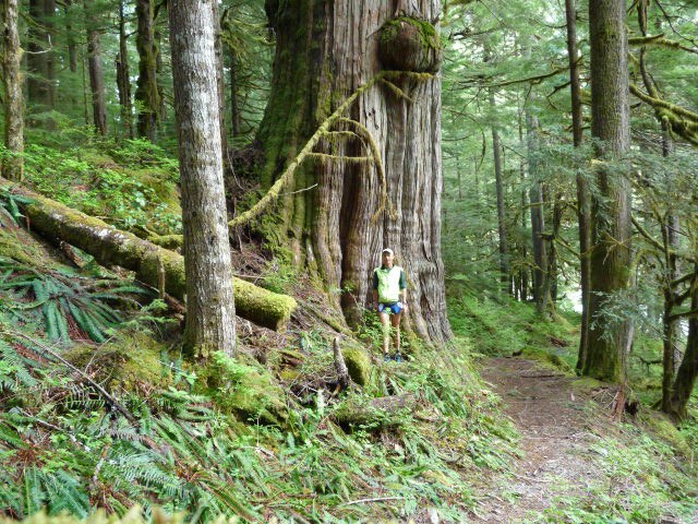
Impressive Cedar tree near the bridge (see pic). Passed a group of about 15 people with large backpacks 300 yards from bridge, headed upstream. Trail is in decent shape, again with a lot of large blow-down, but partially chain-sawed out so it is easily passable. Biggest obstacle was Thunder Creek crossing as the logs that were there last year were gone. Got lucky and found a log of the right size and lenght, carried it to the creek and wedged it in between 2 boulders. Also fixed 2 longer but thinner logs as "hand rails". It's not ideal, but better than before. (see pic) The next stream crossing also has no bridge but is pretty easy. The 3-logs bridge across Burnboot Creek (see pic) did not get washed away this winter, so that crossing is easy. After you cross Burnboot it's 200 yards to the hotsprings.
Burnboot Creek - Red Mtn Pass (old PCT) trail:
Just before you cross Burnboot creek on your way to Goldmeyer, the old PCT follows Burnboot creek upstreams for 200 or so yards, passing "trail not maintained beond this point" and "no bikes" signs. See pic for start of old PCT trail. Shortly after the signs the trail starts climbing towards the pass and becomes a lot easier to follow than the first 200 yards. I went about 1000ft above the river level before I hit snow and turned around. There are some blow-downs, but not to bad. I did the Alpental, Snow Lake, Middle Fork, Red Mtn Pass, Alpental loop run last year. Unless you bring ice axe I would not recommend this trail until the steep, NE facing gully just below the pass has mostly melted out. Run time: 34 min out and back
Goldmeyer back to middle fork trailhead:
Run time 1:34h. Never saw the group of 15 hikers, bt did see one guy on a mountain bike about 1 mile from the trailhead. The poster on the trailhead relating to mountainbikes on the middle fork trail says that it is open to mountain bikes ever other day from "June 1st 2008 to (sometime in) October 2008". Not sure if the regulations have changed since then. USFS, how about putting up a new poster while you're out there giving those without parking pass a ticket?
Trailhead to car: about 2 miles on the road, 15 min of running.


Comments