
TL/DR version: Some of the best hiking I've done in 10 years living in WA. Stellar views abound. So do the bugs.
Started out from the Hannegan TH around 1:00pm on Saturday, Aug 4, after a short night's sleep in the car at the permit office in Marblemount (open an hour earlier than the service center in Glacier). WTA volunteers (hurray!) and swarms of black flies (boo!) were out in force along the first 4.5-mile stretch heading up to Hannegan Pass. Snowy views of Ruth Mountain and promises of breezes on the other side of the pass kept up spirits. We opted to forgo the hike up Hannegan Peak, but probably should have gone for it as Saturday was the least hazy/smoky day we had. Stopped for water at a small unmarked stream below the switchbacks NE of the pass, before Boundary Camp.
We opted to do the loop counter-clockwise, and this proved to be the consensus pick among our group of four, all of whom are recent dads and didn't have the legs to make a push up the ridge on Day 1 or Day 2 (more on the benefits of this direction below). We made camp at Copper Creek just as the thunderclouds started to roll in and enjoyed the gentle rain on our tents as we bedded down for the night.
Day 2 was from Copper Creek to Indian Creek, and proved to be an unexpectedly fun and adventurous day on what we had otherwise billed as a rest/river walk day. The cable car across the Chilliwack is definitely the way to go versus the river ford. Just a short 1.2 miles from the cable car is a great spot to fill up on water and soak your feet/take a nap at Brush Creek. Highly recommend making the stop there, as the 3.4 miles from Brush Creek to Indian Creek are long ones through extended stretches of thick brush requiring plenty of noisy presence-making. We spotted a black bear sow in the brush who was still there 10 minutes later after we had slowly backed up the trail to give her space. She and her cub (now both uphill about 50 feet from our location on the trail) slowly sauntered off after the second sighting, and we calmly continued on our way, bear spray in hand until Indian Creek. There was a downed tree just past our bear sighting that required packs off and under which we moved as efficiently as possible.
The suspension bridge over Indian Creek capped the day's adventures. We tucked in to an unclaimed campsite at the far end of camp (sorry NPS, but we were not overly enthusiastic about your description of the overgrown trail to the no-man's-land Bear Creek Camp at dusk) and waited three hours until around 8:00pm before we decided it was unlikely another party was coming to claim their permitted site, and finally pitched our tents. There was a fair amount of twigs and branches snapping in the woods (in otherwise calm weather) throughout the night, which further solidified our decision to not have pushed on to Bear Creek.
Day 3 started with an easy walk down to the Indian Creek/Chilliwack River fords. As you approach the water, look for pink flags on both sides of the first crossing to guide you. When we crossed around 8:00am, water was calf-high and relatively easy to navigate. Once across the first crossing (heading west), we continued to follow the pink flags across a large gravel bar that led to the second crossing. Here, we had beta from a couple who had crossed in the opposite direction that there is very large downed tree with a medium-sized blue swimming hole to your right (heading toward the ridge), and that was the best place to cross, as it is not flagged. We found the log and the swimming hole, crossed, and went for a quick swim before getting our boots back on for the long haul up the switchbacks.
The good news about heading up the ridge is more than 2/3 of your elevation is gained under relatively good tree cover. We didn't end up putting on sunscreen until around 4,400 when the switchbacks break out above the treeline and you're starting to go up through hot brush, all the while thinking your're going to duck back into some trees, but never really do. All the more reason to break your camp as early as you can that morning and avoid having to hike the last 3.5 miles to Copper Lake in the worst heat of the day. Other than the heat above the treeline, the only other minor annoyance (no bugs!) on the push upward were a few easily hopped logs down across the trail. None required packs off.
From above the treeline heading toward Copper Lake, we spotted a small fire flaring up on the SW side of Nodoubt Peak across the valley. We talked to the NPS ranger the next day at the fire lookout and she said they'd sent a helicopter to check it out.
The one section before topping out on the ridge we had heard might still have some snow was crossing a large boulder field about 1.25 miles before Copper Lake. The trail clearly ducks just below the remaining snow, and while slightly exposed, the boulder field crossing posed no problems. Alas, I'd carried a pair of microspikes all that way for nothing.
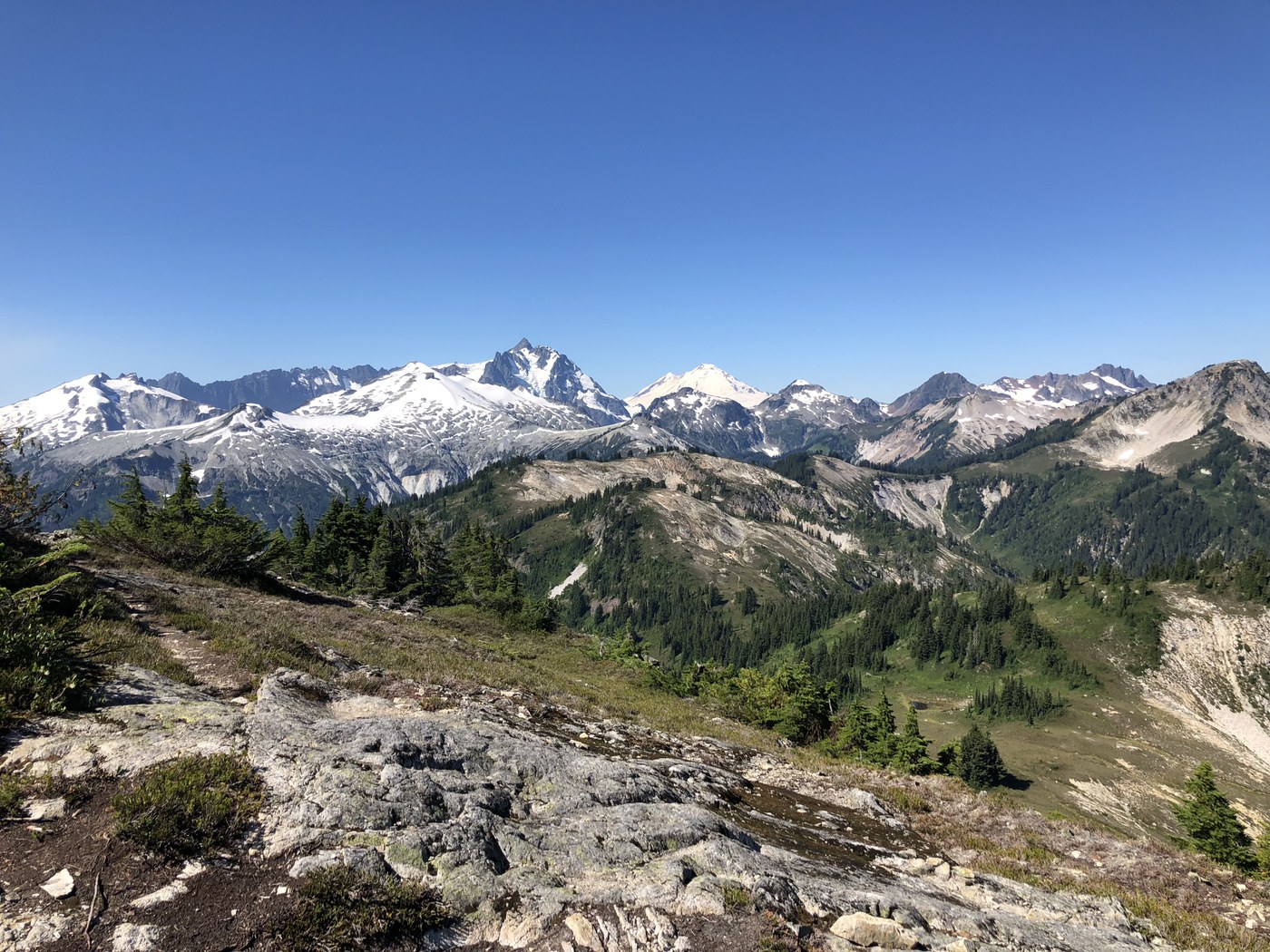
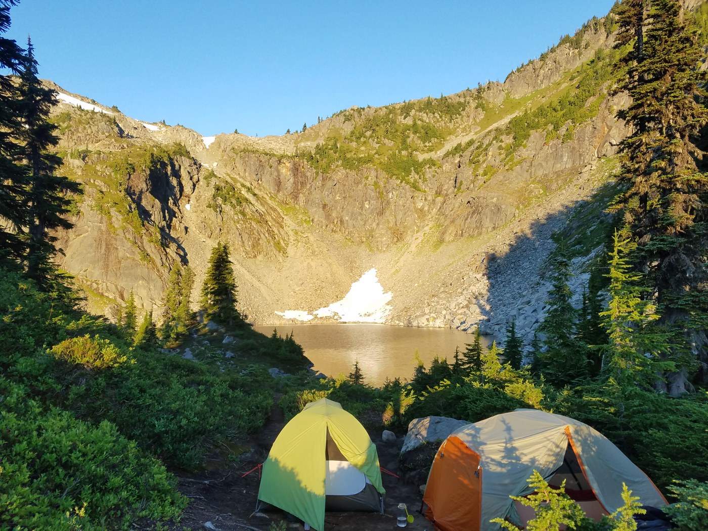
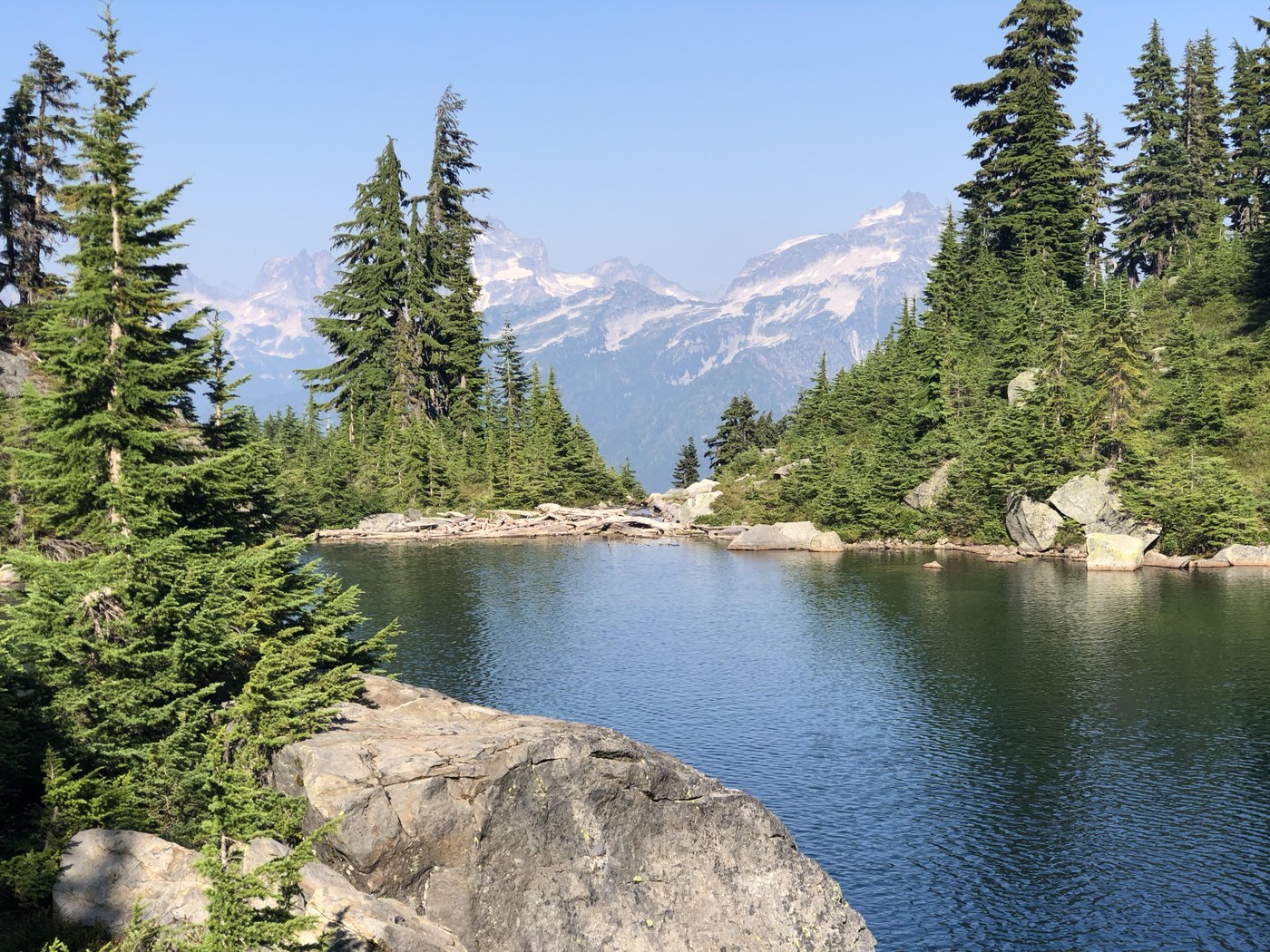
Swimming in Copper Lake was a godsend after a hot day gaining the ridge. The mosquitoes kept us dancing around camp or hunkered down in our tents the rest of the evening, even after dusk. That said, all agreed (including a previously incredulous Coloradan) that this must be one of the Top 10 campsites in all of the Great American West. The haze throughout the valley was thick in the afternoon, but clearer in the morning enough to enjoy some pretty crisp views of Whatcom, Challenger, etc. And the moon rising across the valley with a galaxy full of stars was equally surreal/spectacular at night; set an alarm if it's clear.
The push up to the fire lookout from the lake on Day 4 did not mess around -- steep and stunning switchbacks make their way above the lake as though it were on fire, and soon enough our legs were. The view from the lookout, much like the camp we left below, must be one of the singularly greatest west of the Mississippi (begging the question how many great views are actually east of the Mississippi), and surely in all of North Cascades NP. It's the kind of view that makes you want to return to the trailhead and civilization if only to rattle off a resignation letter for whatever job is keeping you from wandering that and other equally impressive ridge lines for years to come.
Coming down off the ridge (begrudgingly), you're still treated to stellar views and the teasingly distant line of the trail hundreds of feet below as you make your way toward Egg Lake. We opted to carry extra reserve bags of H2O to treat along the way rather than drop the extra 300 vert. ft. to Egg Lake for a fill-up. If you're smart, you can make it from Copper Lake to Boundary Camp (or a stream running down the scree field just below the switchbacks back up to Hannegan Pass that looks to be good for at least another couple weeks) without the detour to Egg Lake. Two small streams marked on the Green Trails map below 5,400 on the Copper Ridge Trail heading back toward Boundary Camp are bone dry this time of year.
The final push back up over Hannegan Pass was a breeze compared to the climb up from the Chilliwack to Copper Lake, and we cruised the last 4.5 miles from the Pass to the TH in record time knowing that a good long soak in Ruth Creek, followed by pizza and beer in Glacier, awaited us. Prying ourselves off those bar stools was nearly as hard as prying us away from some of the best views of the Cascades one could hope to have.
Comments
LifeToTheFullest on Copper Ridge Loop
Which lakes are pictured here?
Posted by:
LifeToTheFullest on Jan 23, 2019 06:34 PM
mattabouttown on Copper Ridge Loop
Both pics are of Copper Lake. The top photo is looking west across the lake; the bottom photo is looking ESE across the Chilliwack Valley.
Posted by:
mattabouttown on Jan 26, 2019 02:29 PM